Tuesday, April 25
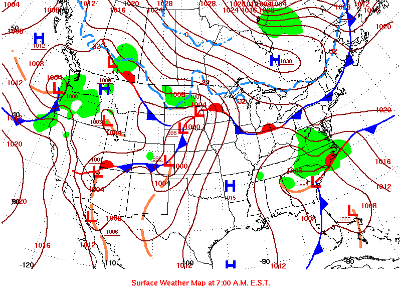
An extended period (of about 3 weeks) of abnormally warm, dry weather had been in place prior to April 25. For example, every day from April 6 to April 24, the temperature in Albuquerque (average of high and low) was at or above normal. And on seven of those days, it was at least 8 degrees above normal. No measurable precipitation occurred there from April 2 through April 24. But April 25 marked the beginning of a changed pattern. As shown on the daily surface map for April 24, the first in a series of disturbances was approaching from the northwest.
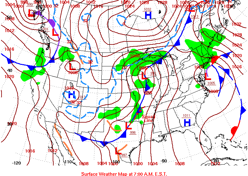
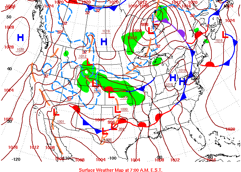
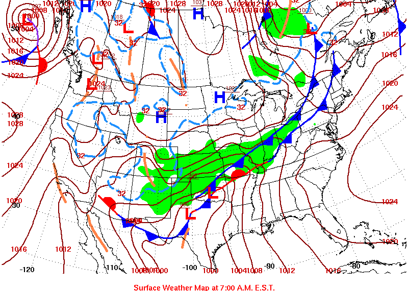
By Tuesday, April 25, the slow-moving front associated with this leading disturbance had moved into northern New Mexico, the multiple centers of low pressure associated with this poorly organized disturbance had shifted east and south, and precipitation was starting to break out in New Mexico:
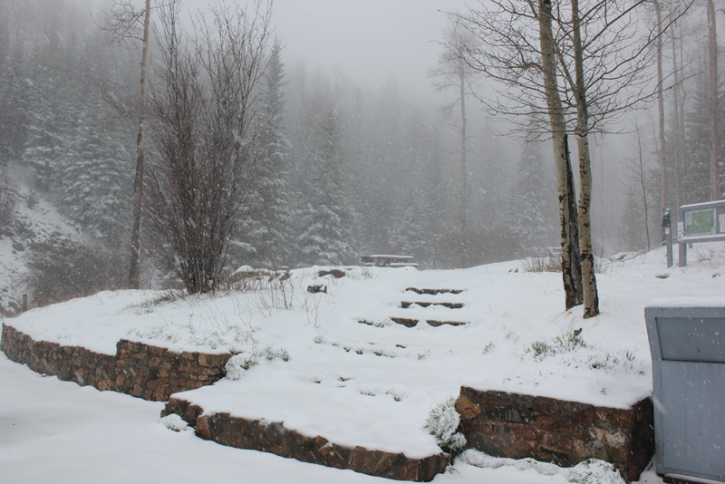
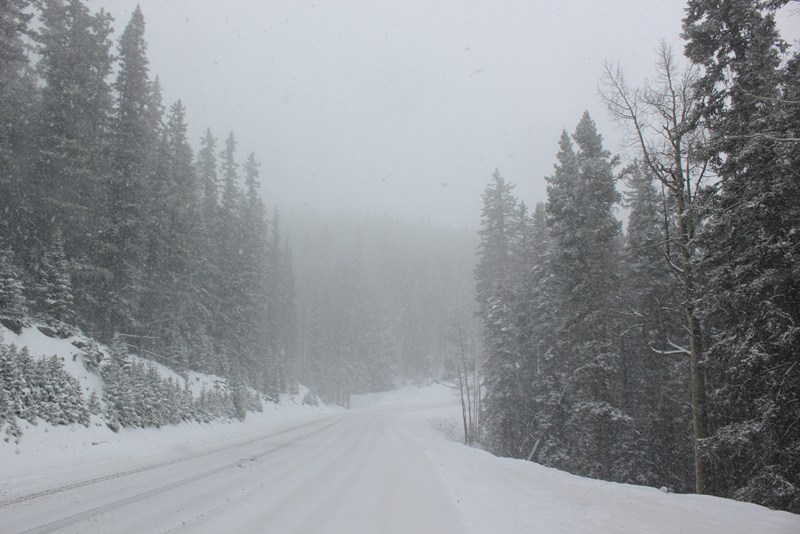
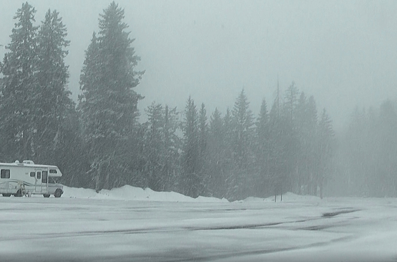
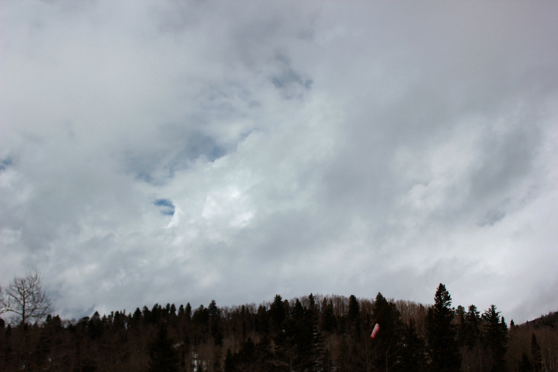
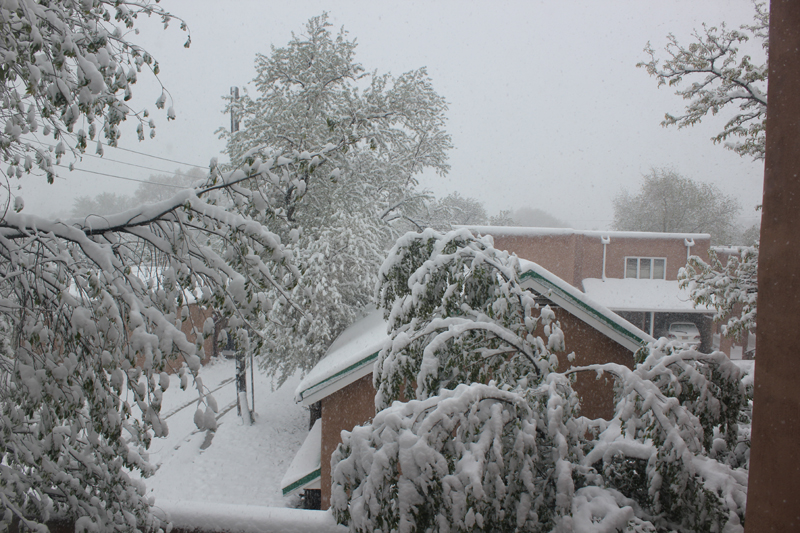
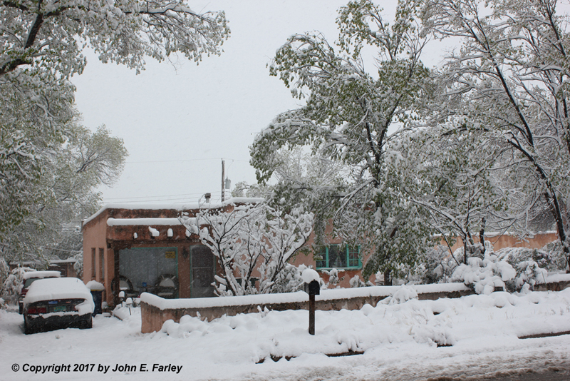
The air was still fairly warm in most of NM ahead of the cold front, though cooler than on previous days due to clouds and precipitation. At lower elevations, it was warm enough for rain. However, in the mountains above around 8500-9000 feet the precipitation occurred in the form of snow - and in some places, thundersnow, since the precipitation was convective in nature. Hoping to see some thundersnow, I made a couple trips up NM route 475 during the day. The first was in the early afternoon, as precipitation moving across the state became more convective in nature. As I drove up on this first trip, it was rain up into Hyde Memorial State Park, elevation around 8300 feet, but by the time I reached the upper part of the state park, there was snow on the ground and the falling rain became mixed with snow. By around elevation 9000 feet, it was all snow, and from the Big Tesuque picnic area (elevation 9675) up to the base of Ski Santa Fe (elevation 10350) there was a new snow accumulation of 3-4 inches. At times the snow fell quite heavily, sometimes accompanied by strong outflow wind. I was not successful in catching any thundersnow, although on the rare occasions when I could get a phone/internet connection (often not an easy thing in the NM mountains), I could see that lightning strikes were occurring as close as the Truchas area, less than 20 miles to my northeast, as a particularly heavy cell moved up into the mountians in that area. In fact, thundersnow occurred not only around Truchas but also pretty much everywhere in the mountains from Taos Ski Valley to the Colorado state line, so my idea that there could be thundersnow was not crazy! Here are a few pictures of the falling and accumulated snow in the mountains:
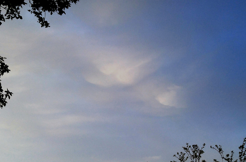
After a while the band of precipitation passed and it began to clear, so I headed back down. But another band of rain and snow showers was off to the west, over the Jemez Mountains, and producing some lightning strikes there. As it approached, I headed back up again. By the time I was on the way up, a strong thunderstorm had developed at the southern end of this line, and it produced heavy rain and some small hail in Bernalillo, Placitas, and the northeast part of Albuquerque. Again it was rain up into the state park, but mixed with snow at the upper end of the state park and was all snow by a mile further. This time I did not go all the way up, but stopped and watched the storm from a mile or two past the state park. There were heavy bursts of graupel (snow pellets) alternating with large snowflakes, and again gusty outflow winds, but no lightning made it this far north - despite the fact that there was continuous precipitation from the thunderstorm in the ABQ area up into the Sangre de Cristo Mountains where I was. I don't know how much more snow this produced in the highest elevations around the ski area, but even where I was it was enough to again cover the road. It passed after perhaps an hour, so again I headed down, this time calling it a day. But as the band of precipitation headed east, it had one more thing to offer, this attempt at sunlit mammatus over Santa Fe:
Wednesday, April 26
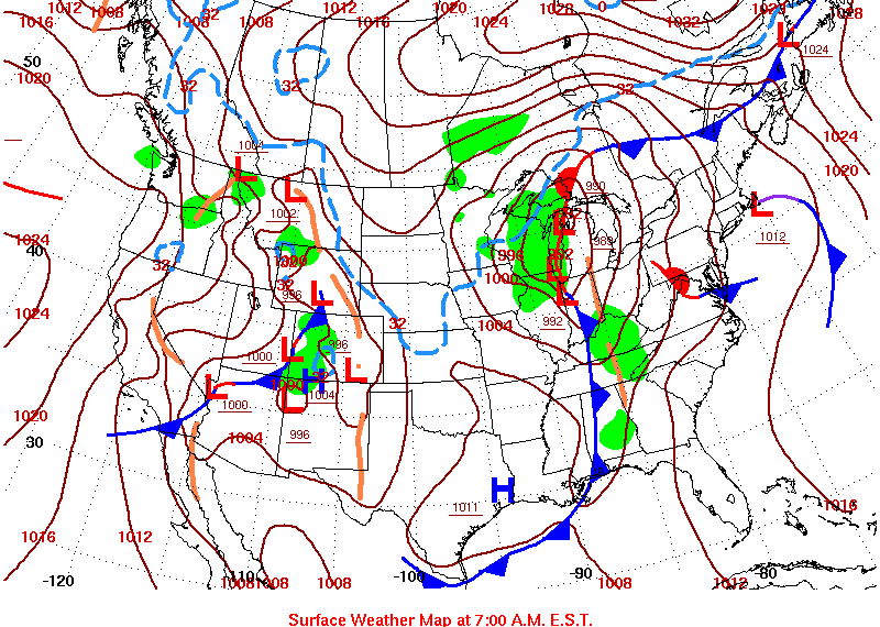
This day was pretty much a break in the weather. The precipitation by now had pushed east onto the eastern NM plains and into the TX panhandle and eastward, as the cold front had pushed through most of New Mexico leading to clearing skies. The main storm system was still well off to the northwest, over the Pacific Northwest with the upper low still over the Pacific Ocean off British Columbia. All of this can be seen on the April 26 surface map:
Thursday, April 27
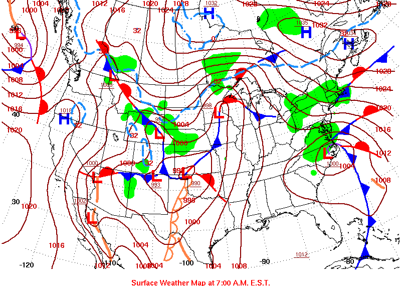
The effects of the next impulse coming down from the main storm were felt on Thursday, April 27. Looking at the surface map below, note that the cold front associated with the first impulse has now moved all the way to the Gulf of Mexico, while several areas of low pressure associated with the next impulse are scattered around Colorado and New Mexico. At this time the main upper low was still well off to the northwest, though, in the Pacific Northwest:
With the airmass warming and becoming more unstable ahead of this next impulse, there would again be a chance of thundersnow in the mountains. The precipitation was lighter, because the main moisture return had not yet begun, but it was convective in nature, and in fact there was again thundersnow in the mountains. While there was not enough snow to create significant accumulations in the mountains above Santa Fe, I did actually get closer to thundersnow (about 15 miles) than on Tuesday. Heavier cells passed just north of the mountains above Santa Fe, creating thundersnow in a roadless area in the mountains east of Espanola - only about 15 miles from where I drove up into the mountains near Ski Santa Fe and experienced only light showers of snow and graupel. I was a little too far south to experience any thundersnow, but I was able to document the convective nature of the snow showers in the mountains:
Thursday, April 28
Up to this point, all the snow had been in the mountains, mainly above about 8500-9000 feet. After all, this was late April. But by now, the unseasonably cold upper low was getting closer, and the jet stream circling around the south side of the upper low was right over northern New Mexico. The second impulse has moved east into TX and OK, forcing what had been a cold front over the northern gulf back northward as a warm front from TX eastward into GA. At one point I had considered a plains storm chasing trip to observe severe weather somewhere in NW TX or SW OK, but with models indicating storms would not likely fire until after dark, I decided to stay in Santa Fe and watch what was increasingly looking like it would be a significant end-of-April snowstorm. By this time, the upper low was drifting generally southward along the CO-UT state line, eventually to cross over the Four Corners into New Mexico. Note also that to the west of the TX/OK areas of low pressure, a reinforcing shot of cold air was surging southwest through New Mexico:
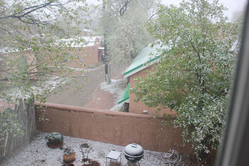
What all this meant for NM was that, as the jet stream generated precipitation over northern NM, the snow level would be much lower than in most previous days. Most forecasts for Santa Fe were that it would still be in the form of rain this day, but that turned out not to be the case. Snow developed across the Santa Fe area early in the day, starting around 8:30 a.m., and through the course of the day several waves of snow moved over the city. Although there was some melting between periods of snow, and the snow did not accumulate on streets and sidewalks, I measured nearly an inch and a half of snow over the course of the day. And at times the flakes were quite large:
This was just a teaser for what was about to come, though. As usual, there was some vacillation among the models on just how much snow might fall in Santa Fe, although there was agreement that there would be some, there could be a lot, and there WOULD be a lot in the mountains and somewhere on the eastern and northeastern plains. As the upper low drifted closer, the band of snow under the jet stream shifted southeast, and a lull in the precipitation occurred over northern New Mexico. But even by the evening of the 28th, a lot of snow had fallen in the mountains above Santa Fe, with the Santa Fe snow telemetry site not far from the ski area reporting 8 inches of new snow.
Friday, April 29
This was the day of the big snow! By now, the upper low had shifted southward into western NM, from where it would drift slowly east before turning to the northeast. The main surface lows with this system were over southern OK and TX, with a very large area of moisture-fed precipitation north of the stationary (soon to be warm) front extending ENE from the low, and in the cold air northwest of the surface low pressure. This meant precipitation in some form occurring most everywhere from NM and CO to the Great Lakes. Heavy snow in parts of CO and NM, and heavy rain eastward to the Great Lakes north of the warm front. As the day went on, severe weather would break out along and south of the warm front, with flooding rains along and north of it. Here is the morning surface map for April 29:
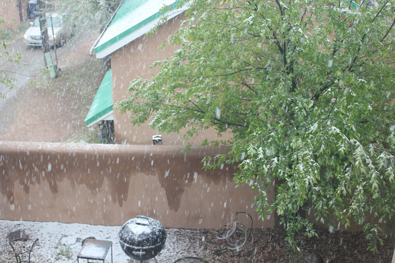
As moist, unstable air circulated around the upper low over western NM, a heavy band of snow set up over and just west of the Sangre de Cristo Mountains early in the morning, including the Santa Fe area. From early though mid-morning, snow fell at rates faster than an inch an hour. Here is a picture taken during this heavy phase of the storm:
Visibility was as low as 1/8 mile at times, and the snow quickly piled up. By 10:30 a.m., 6.7 inches of new snow had fallen at my location since midnight. After this the snow lightened, but another 0.3" fell by 2 p.m. when the accumulating snow ended in Santa Fe, bringing my measurement for the day to 7 inches, and the two-day storm total including the previous days snowfall to 8.4" Generally amounts ranging from six and a half to nine and a half inches were reported around the Santa Fe area. According to the local newspaper, this made it the heaviest snowfall of the 2016-17 season, more than doubling the amount of the previous heaviest storm in January. (That storm occurred during the atmospheric river event, discussed on the other Web page linked from my 2016-17 Winter Weather Observations page.) Note in the picture above that the trees are leafed out. With the snow falling on the leaves, there was a heavy snow load on the branches, and there were a number of reports of branches falling and in at least one case, an entire tree. This led to some power outages around town, with 1400 customers out for about 4 hours. However, with a little more snow and more wind, it could have been a lot worse than it was.
Along the north-south band of heavy snow that set up near the central mountains, amounts of 10-13 inches fell in the Eldorado and Lamy areas a little southeast of Santa Fe, and around a foot in the Tijeras, Sandia Park, and Sedillo areas between the Sandia and Manzano Mountains east of Albuquerque. These areas are quite a bit higher than Albuquerque, but nowhere near the highest in the Sandia and Manzano Mountains. Undoubtedly more snow fell up there, as it did in the Sangre de Cristo Mountains northeast of Santa Fe. The Santa Fe snow telemetry site eventually reported 15 inches, but the total was certainly more because that report was at 2 p.m. on the 29th, and snow continued in those mountains into the evening. The true total was probably at least 20 inches. Another snow telemetry site northwest of Las Vegas, NM reported 16 inches, as did the town of Tres Ritos near the Sipapu ski area.
Snow this late is not unusual in Santa Fe, but this much snow is. According to the local paper, this is the heaviest snow on record this late in the season, although records from a few years are missing. The latest measureable snow in Santa Fe occurred on May 7, 1969. Any snow this late is pretty unusual in Albuquerque, where the official reporting station received 0.7" but some locations in the northeast heights got around two and a half inches. The official snowfall there was the fourth latest on record, ever.
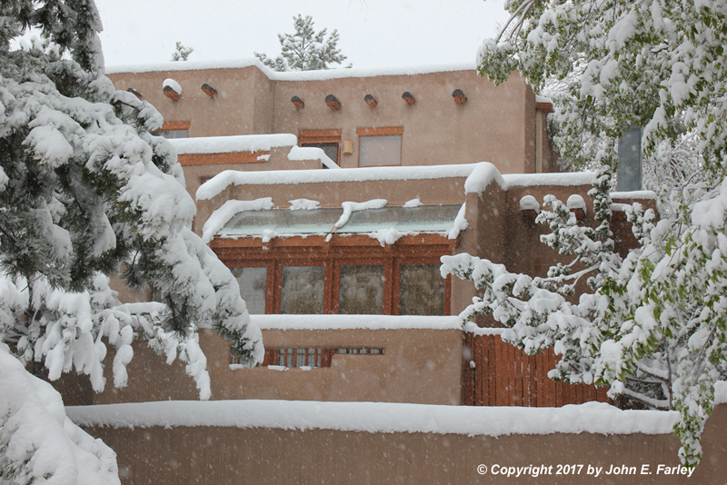
Here are a couple more pictures showing how much snow fell in Santa Fe:

And I will wrap up my pictures with this one, showing how good Santa Fe Style looks in snow!
Most of central and eastern New Mexico got snow from this storm, and some other places got a lot. Several places on the east slopes of the Sangre de Cristo, Sandia, and Manzano Mountains got 6-12 inches, and 4-8 inches fell many places on the eastern and northeastern plains - in some places driven by some very high winds.
This storm had considerable impact in New Mexico, resulting for a time in the closures of portions of both I-40 and I-25, as well as a number of other roads in the northeast part of the state. But much of the impact was positive, as the storm provided much-need moisture and likely made the fire season (which peaks in May and June) shorter and less severe, as well as helping to replentish reservoirs and aquifers. The impacts of the storm extended well beyond New Mexico. Of course there was the major flooding in parts of the South and Midwest and the tornadoes in Texas and elsewhere - at least 13 people had died as a result of floods, tornadoes, and wind at the time of this writing. But that aspect of the storm has been well-covered elsewhere, so on this page I am sticking to the winter impacts, which were also considerable outside NM. In Colorado, where the storm began earlier than in New Mexico, many areas from the Front Range foothills eastward, and generally from the Denver/Boulder area southward, received considerable accumulations, again with a number of road closures. Generally around Denver and Boulder 3-8 inches fell, but some places in the foothills just west of those cities received much more, in the range of 18-24 inches. Farther south, the Sangre de Cristo Mountains in Colorado also got a lot of snow as they did in New Mexico, with one location there, northwest of San Isabel, getting 39 inches of snow, the highest report I have seen with this storm. But much of the higher terrain on the east slopes of the mountains near Pueblo, Colorado Springs, and Walsenburg got in excess of a foot, with some places in excess of two feet. Lesser but still considerable amounts fell on the southeastern plains of Colorado, with 6-12 inches in many areas and up to 20 in some.
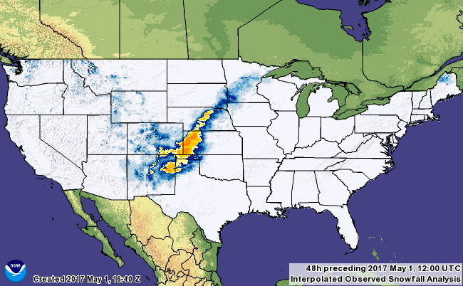
After passing New Mexico, the snow moved northeast across the northwestern TX Panhandle and the western OK Panhandle, dropping up to a foot of snow in a few spots and causing more road closures. In western Kansas, 12-16 inches fell in portions of the Dodge City and Goodland National Weather Service areas, with wider areas that got lesser amounts. And in many areas, blizzard conditions with near zero visibility and winds up to 65 miles per hour. The combination of wind and snow forced many road closures, and downed trees and power lines in many areas, resulting in extended power outages. After Kansas, the snow continued northeastward across south central to northeastern Nebraska, the southeast corner of South Dakota, and then across southwestern, central, and northeastern MN. The map below shows 2-day snow accumulations ending at 6 a.m. MDT May 1. Note that this map understates accumulations in parts of Colorado (especially the northern part) and New Mexico because the snow began before the time period covered by the map, and also possibly in parts of Minnesota where snow continued beyond the early morning hours of May 1. However, it does give you a sense of the snowstorm's track through roughly the eastern halves of CO and NM, then northeastward across the Plains to the Upper Midwest.
A public information statement from the NWS summarizing the snowfall amounts around New Mexico can be seen here