AR events can produce exceptional snowfall amounts of many feet in the Sierra, which exceed snowfall events even in other mountainous areas of the United States. Although the greatest effects of AR events are in the Pacific coast states, they can often have effects far inland, producing heavy snow in the Rockies and storm systems that traverse the entire nation, producing heavy rain and snow and sometimes severe weather depending on the track of the jet stream and the embedded storms and location relative to the track.
The AR was very active in January, 2017, producing extended heavy precipitation events in California and other Pacific coast states from January 2-5, January 7-12, and again from January 18-24. As it happens, my wife and I were taking a winter vacation during that period, travelling from Pagosa Springs, CO through the Four Corners area to the Las Vegas, NV area, Death Valley National Park, and Mammoth Lakes/Mammoth Mountain, CA. As a result, we expreienced this AR event from a number of different perspectives. Below I will describe and discuss some of the events we experienced, including some pictures, data, and news reports.
January 5, Cortez, CO
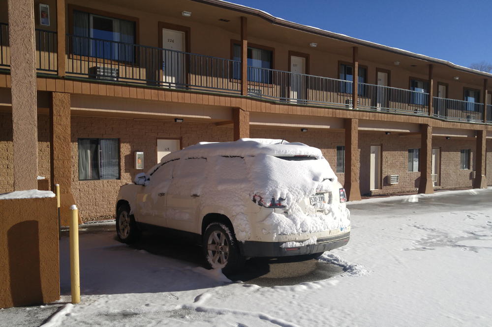
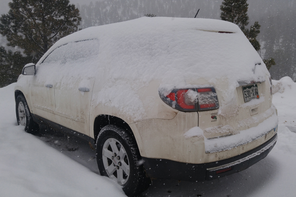
We had initially planned to start our trip January 6, but due to a forecast of snow in the higher altitudes between Pagosa Springs and Cortez, decided to start out in the afternoon on January 5 and go as far as Cortez. As things turned out, this was a wise decision. The afternoon of the 5th, when we left, the first of the three AR storms was passing through CO, with the surface low passing north of Pagosa Springs and our travel route in the warm sector. As a result, the snow level was pretty high, with Pagosa Springs and Durango having largely escaped accumulating snow up to that point. We did encounter a little snow around the highest elevations, Yellow Jacket Pass and near the Hesperus ski area, both somewhere around 8,000 feet. But for the most part it was dry, with just a few widely scattered rain and high-elevation snow showers. However, after the low passed to the north, a cold front was forecast to surge south behind the low and across the Four Corners region, producing an uptick in precipitation and a changeover to snow. As we neared Cortez, I noticed a definite increase in convective rainshowers as the front got closer. Unusual for me, I was focussed more on the trip than the weather, so I was unaware of the extent to which the strong forcing on the front was leading to strong convection. But while we were eating dinner, I was made aware, as the roof of the restaurant was loudly pounded by a burst of hail. The hail was small, just pea-sized, but there were lots of reports of it coming down hard around Cortez. This was occuring right along the cold front, and by the time we were through with dinner the precipitation was all snow. As we were walking to the car, I heard - and commented upon to my wife - something that I thought sounded kind of like thunder. And then just as I finished scraping the snow off the car, there was a flash of lightning. It had indeed been thunder; we were experiencing thundersnow! Probably should have gotten the phone out then and gotten some video, but we needed gas and my focus was more on getting that. There was more lightning as I gassed up the car, but by now the lightning was to the south and the snow was decreasing. I had hopes of getting some thundersnow video once we got back to our motel, but by that time the snow had stopped and the lightning was only distant flickers in the south. So, no video, but still an impressive storm to experience. Checking radar pretty much verified what I thought - a line of thunderstorms along the front was producing hail along its leading edge and snow in the stratoform region of the storm behind the cold front. This had dropped a quick inch or so of snow in Cortez after the hail, and was producing lightning, hail, and snow throughout the Four Corners area. Another, wider, band of snow was to the north, moving southeast. Overnight, this produced another inch or two of snow, resulting in a total of between 2 and 3 inches in Cortez. I will say this: rain, then hail, then thundersnow, then snow, along with sharply dropping temperatures (from a high of 46 on January 5 to a morning low of 1 on January 6) is the perfect combination for icing roads, cars, parking lots, and just about everything else. Here is how my car looked the morning of the 6th:
What the picture cannot show is that the driver side door was frozen shut and I had to crawl across from the passenger side (which was facing the sun) to get it open. The roads were very icy and snowpacked through the remainder of Colorado and into NM, until we reached an area very little snow had fallen. Tnat did not last long, though, and it was snowy again by the time we reached AZ. Fortunately, the roads there had been well plowed and heavily salted, and conditions were decent from there on.
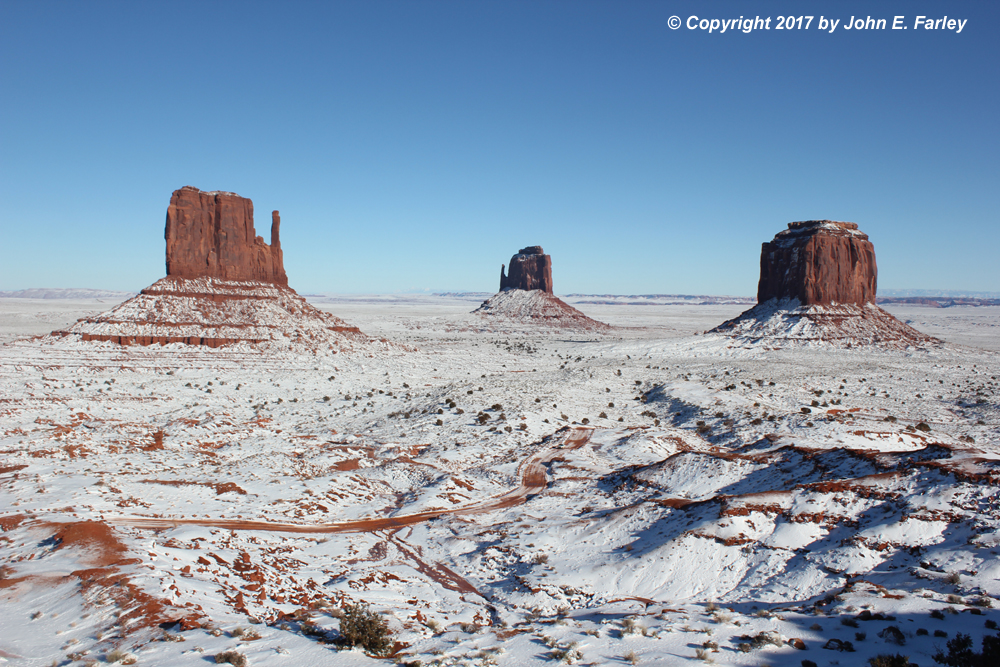
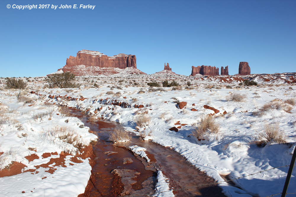
January 6, Monument Valley
Our plan for this day was to drive to Kayenta, AZ, then go slightly north of there to visit Monument Valley, and return to Kayenta for the night. On the morning LSRs I had noticed a report of five inches of snow at the Monument Valley Visitor Center, so I was stoked at the opportunity to see Monument Valley in snow. And we were not disappointed! The red rock features of Monument Valley are absolutely spectacular in snowy surroundings. So much so that we did not mind at all that the auto loop through the Tribal Park was closed because of the adverse conditions. Here are a couple pictures, the first from the Visitor Center and the second from along route 163 in far southern Utah:
January 10-12, Las Vegas, NV Area
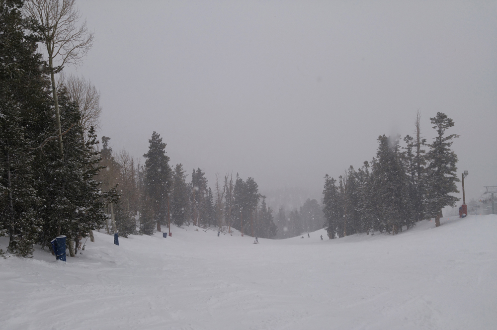
From January 6 through 9, we were mainly between storms, in the general Las Vegas area from the evening of the 6th on. On the 10th and 11th the precipitation from the second of the three major AR storms was mostly north of the Las Vegas area, but there were some high winds with pieces of palm trees and other debris flying around the Strip area at times. A gust of 51 mph was recorded at the Las Vegas airport on the 11th. Gusts as high as 88 mph were recorded near Independence, CA in the Las Vegas NWS county warning area on the 10th, and a gust of 59 mph was recorded at a high school in Las Vegas on the 11th. So although it did not rain, it was windy. By the 12th, precipitation did move into the Las Vegas area. On that day, I had arranged to go skiing at the Lee Canyon ski area in the Spring Mountains northwest of Las Vegas. Snow was falling from about the 6000 foot level on up as I drove to the ski area, and it kept coming down all day. Around 4 inches had fallen by the time I got there, and three more came down through the day while I was skiing. This led to a great powder day in a place, where according to several people I talked to, they do not happen very often. Except when you have an atmospheric river, I guess. The snow continued through that night, the next day, and into the following day, with the area eventually getting 24 inches from the storm. That is a big storm for that location, although the next storm in the series would give them even more, 5 feet between the 18th and 25th of January. But I would, by then, be in a place that would get even more! When I returned into Las Vegas after skiing, rain had spread into the entire city and would continue throughout the night and into the next morning, when we were leaving. While driving in Las Vegas and looking for a gas station, I slid worse than anything that had happened while I was driving in the snow (although I did have to wait briefly coming down while the road was closed to get a car un-stuck). It turned out that, since it had not rained for a week or two in Vegas, the roads had become coated with dust and grime that became very slippery in the early stages of the rainstorm. I witnessed a number of wrecks while driving back to the hotel, but was able to avoid further difficulty after my initial skid. Here are a couple pictures from this day, showing the snow coming down onto a powdery ski run, and my car again covered in snow:
January 18-24, Mammoth Lakes/Mammoth Mountain, CA
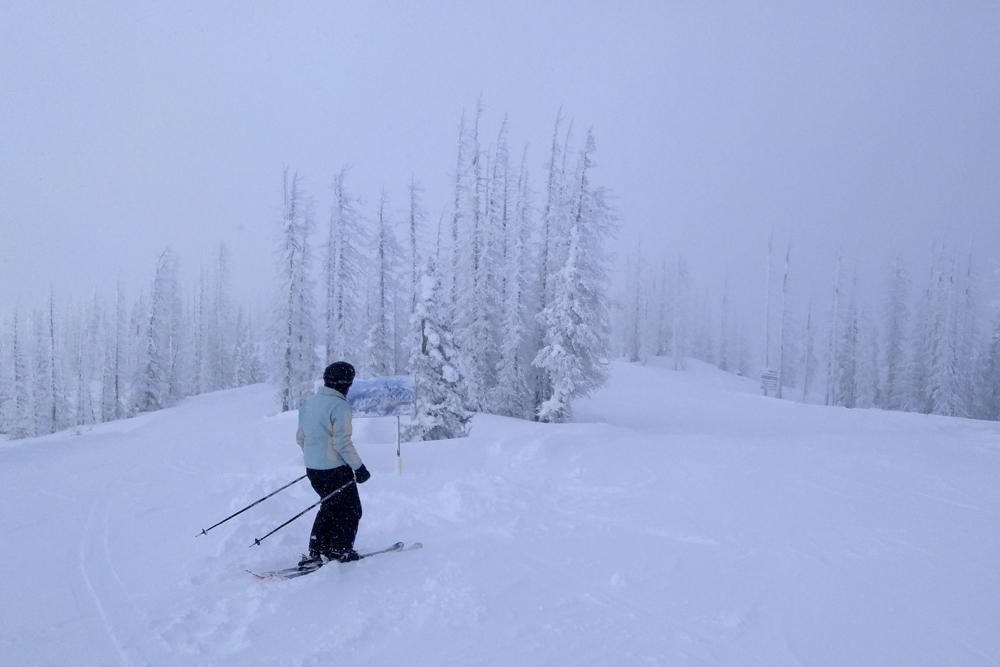
Our visit to Death Valley National Park over the Martin Luther King holiday weekend and our first full day at Mammoth (January 17) were between storms and mostly sunny. But by January 18, the third and perhaps strongest in the series of storms had arrived in Mammoth. From the 18th through early the 24th, total snowfall in the Mammoth area ranged from around 6 feet in Mammoth Lakes to around 8 feet in the lower elevations of Mammoth Mountain Ski Area to 11 feet at the top. The official snow total at the ski area's Main Lodge was 99 inches, or a little better than eight feet! On January 18, when the storm began, I enjoyed good ski conditions during the morning, with some intermittent snow snow showers. It was windy, though. However, as I was eating lunch the snow and wind intensified dramatically, with severe blizzard conditions as I headed back out. I planned to ski a few runs on protected, tree-lined areas low on the mountain, but as I rode up on the lift the wind was so intense it felt like it was going to blow my skis off - far beyond anything I had ever experienced before. I decided it was just too severe, and headed back to the lodge I had started from in the morning. By the time I got there, nearly all of the lifts were closed or on temporary hold, and the gondola you take between the ski area base and Mammoth Lakes was closed due to the high wind. Around 1:30, all of the lifts closed for the day due to the severe conditions. So after a rather long, cold wait, went back by bus, the only way available. I found out the next day that, at one of the ski lifts, the average sustained wind in the afternoon was 80 mph. In other words, basically a hurricane, but with snow instead of rain.

This picture was taken on January 18 at the beginning of the storm, a little before I got on this lift and thought my skis were going to be blown off. By an hour later, all of the lifts were shut down due to high wind.
The storm continued almost without interruption through the 19th and 20th. By the morning of the 21st, when we were scheduled to leave, 3 feet of snow had fallen at our hotel. Here are a couple pictures that will give you a sense of how much snow there was:
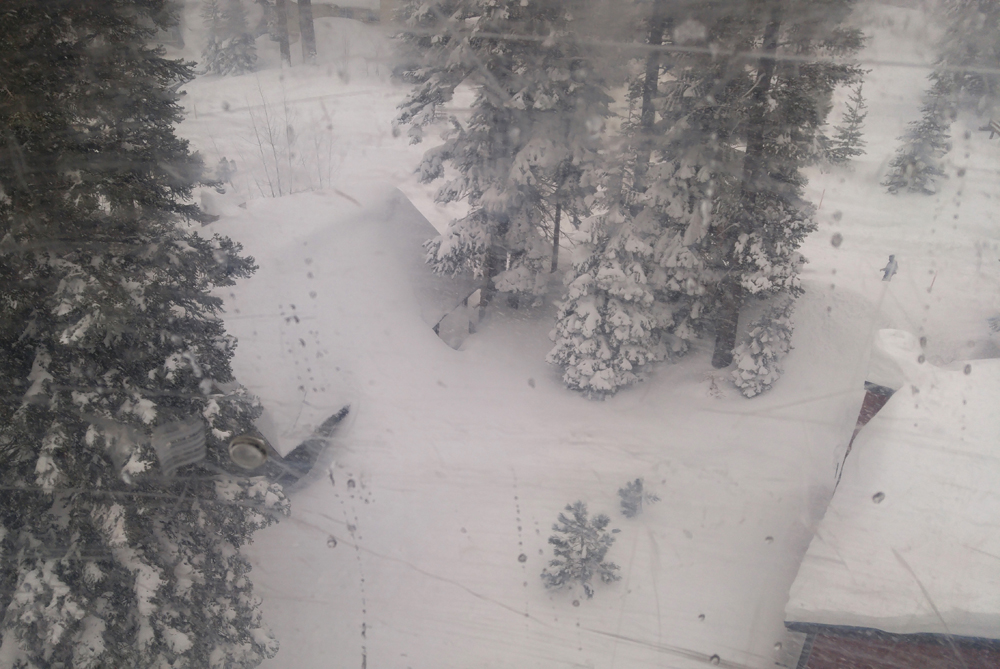
The picture above was taken from the gondola that runs between the base of the ski area and the Village area of Mammoth Lakes the afternoon of the 19th. Note that the snow (of course not just from this storm but from the series of AR storms since mid-December) is over the roof of the house on the left. The picture was taken through the window of the gondola which had scratches and watermarks, so sorry for the quality but you get the idea.
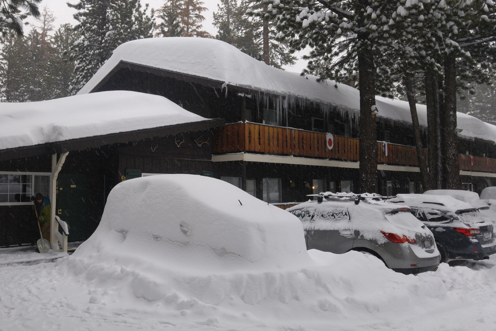
This picture was taken at our hotel the afternoon of the 20th. A little better than 2 feet of new snow had fallen by this time. The buried car is one that had not been cleared since before the storm began. Note also the depth of the snow on the roof.
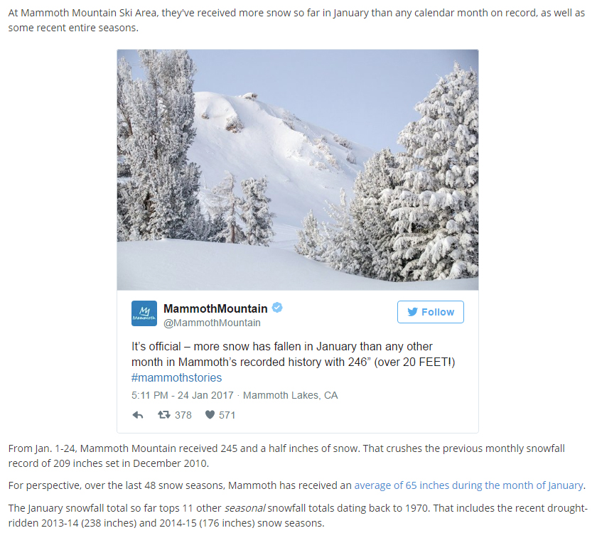
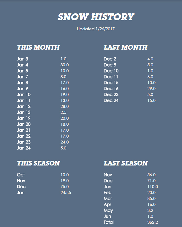
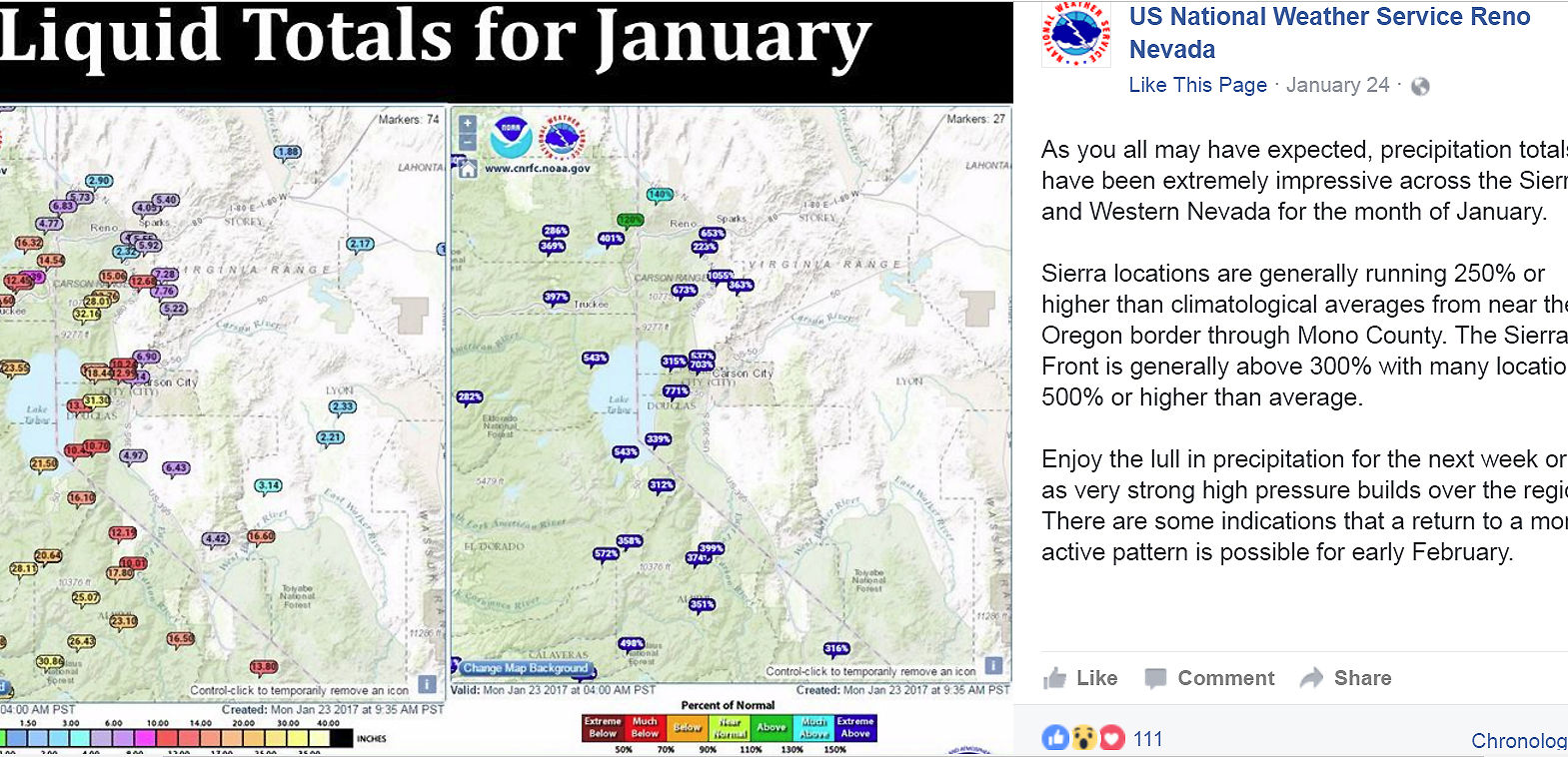
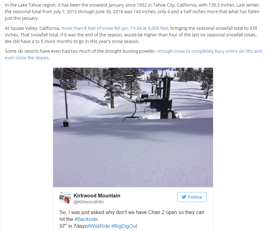
Fortunately, there was a break in the storm the 21st and we were able to leave as scheduled (although CalTran required us to buy and install chains to drive in conditions that turned out to be no worse than I drive on frequently in Colorado during big storms, with chains required only for large commercial vehicles). But the evening of the 21st, after we left, the storm resumed. By the 24th, when it finally ended, it had dumped the aforementioned snow amounts ranging from 6 feet in Mammoth Lakes (in other words, another 3 feet after we left) to 11 feet at the top of the mountain. The January snow at Mammoth Mountain was an all-time record snow for any month, at 245.5 inches-more than 20 feet in one month. That is more than fell in several recent entire ski seasons, a fact that attracted the attention of The Weather Channel. And this table shows the daily snow reports for December and January (note the heavy accumulations began in mid-December), and monthly amounts for the last two ski seasons. The daily reports are for 24-hour new snow in the morning, so often the report reflects snow that fell the previous day. It was not just Mammoth that received exceptionally high amounts snow or rain in January - a number of locations in California and Nevada received 4-6 times their normal January precipitation, or more - and some locations got over 30 inches of precipitation in the one month! That can be seen in this graphic from the National Weather Service in Reno. This report (which includes a picture of a chairlift actually buried in snow at the Kirkwood ski area) describes what happened in the Lake Tahoe area, 100 miles or so northwest of Mammoth.
Several additional AR events occurred in February, with Mammoth receiving another 162 inches of snow at the Main Lodge, bringing the season total to at least 512 inches (more than 42 feet) by the end of February. Perhaps this report will give you some sense of what the Donner Party may have been up against!
January 23-25: Meanwhile, Back Home in Colorado . . .
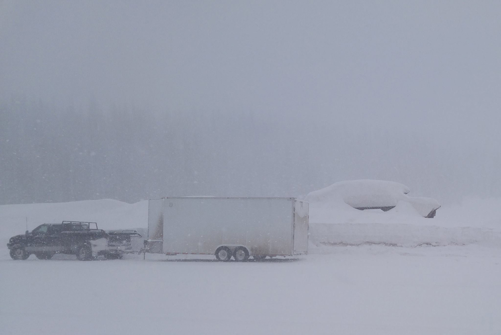
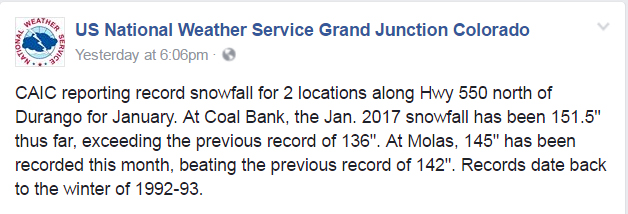
We arrived back home in Pagosa Springs, CO January 23. En route in Arizona, New Mexico, and Colorado, we did encounter some snow from the last piece of the third AR system, as well as some rain in northwest Arizona on the 21st. However, most of the really heavy snow was at higher altitudes than our route, so conditions were pretty manageable. However, when we got home our snowstake showed a solid 2 feet of snow in our yard, quite a bit more than when we left and the most we have seen in the 5+ years we have lived in Pagosa Springs. And in the San Juan Mountains, some of the snow totals reached or approached monthly records, as shown in this report from the Colorado Avalanche Information Center. From Jan 1 through Jan 26, Wolf Creek Ski Area received 161 inches of snow (13.4 feet of snow). (That is an average of more than 6 inches per day.) I headed up there to ski on January 25. According to the forecasts, the storm was supposed to be over, but Mother Nature had different ideas as one last area of upper instability moved over the San Juans. Despite temperatures that never got above 3 degrees F at the ski area, there was enough instability to get some convective snow showers that were pretty intense at times. Several inches fell through the day, bringing the total since the previous morning to 18 inches by late afternoon, with a multi-day storm total of 30 inches. It was great skiing, but it was very cold and visibility was not good - either skiing during the heavier squalls or driving down afterwards. The picture below shows how it looked at the top:
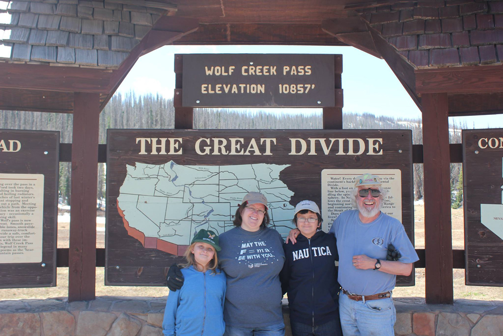
The following two pictures were taken at the top of Wolf Creek Pass. The first one was taken as I was driving home from skiing. The second one is a family picture taken the previous June at the same location. Notice that the top of the snow in the first picture is a good 3 or 4 feet above where the top of my head was in the June picture!
Return to 2016-17 Winter Weather Observation page