
Wall cloud of severe-warned storm near Granite City.

Video capture of same storm.

Same storm, lightning under the wall cloud.
I know everybody is excited about today [4/14], but I'm surprised there is not even a thread for tomorrow [4/15]. In addition to the obvious MS/AL target area, I think there is some potential for a cold-core event in southern and possibly central Illinois. The low-level shear looks good, and while there is not a lot of instability, you don't need a lot for this kind of setup. I like that the low-level directional shear is good, though I wish the upper winds were veered a little more. Another positive is that the 500 mb low is close to the surface low. I think it may come down to whether the atmosphere in the afternoon can recover enough from earlier clouds and precipitation to get strong storms. If it does, and if they can stay discrete for a while, then I think we could have an interesting show in IL east of I-55 and south of I-74. For me, another positive is that although I have morning and mid-day commitments, I should be able to break away by about 1 p.m., which will be plenty of time if things develop, given where the models are now showing the storm. The NAM has the low a bit farther northwest than the GFS, but both bring the front into IL around the time of peak diurnal heating.
On the morning of the 15th, I updated my thinking with this:
Looking at this morning's model runs, NAM has backed off a little on instability in the northern target area compared to yesterday (and the RUC is similar, but a little better), but the HHHR has CAPE as high as 1500 in parts of SW IL. The models this morning also look a little slower on the progression of the front, so I think the storms could go severe as far west as the STL area and points south/southeast along the Mississippi River. So setting up somewhere near or just south of the Metro-East area looks like a good bet. I was a little surprised to see hatched on the SPC tornado outlook as far north as I-70, but if the HHHR is right that could verify. Sun has been out a good bit of the time since the initial rain band moved through, so I think decent de-stabilization could occur. One concern is that the storms could go linear pretty fast, but with good low-level directional shear, I think embedded supercells are possible even if that happens. Individual cells should move almost directly north, and pretty fast, given the direction and speed of the mid-level winds.
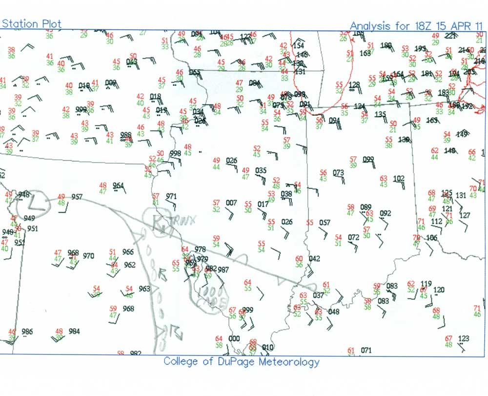
In many regards this forecast panned out, but certain details led to tornadoes farther north than I (or many other forecasters) had thought. A detail which I had observed and considered, but ultimately disregarded in favor of other factors, proved crucial in where tornadoes occurred today. A little after 1 p.m., I downloaded surface data for Illinois and did a hand analysis. A scan of this is linked here. Note the following:
1. A weak warm front-type feature extending from WNW to ESE just northeast of the STL area.
2. An isolated severe storm northwest of St. Louis, right on the warm front (and ahead of the line of storms forming near the cold front), near Bowling Green.
3. Best analyzed instability farther southeast, in and southeast of the STL area.
I did consider targeting the warm front, but ultimately did not because a) the best actual and forecast instability was farther southeast and b) only the one storm near Bowling Green (which ended up producing the first tornado of the day, but I didn't know that then) had gone up by the time I headed out to chase around 3:15, and c) other storms, though somewhat linear, had already gone severe to my southwest and were moving into the area of best instability south of St. Louis.
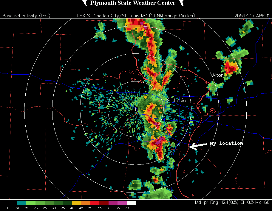
When I headed out, a line of storms southwest and west of the STL metro area had already gotten multiple SVR warnings. There was a somewhat isolated and slightly right-moving cell just south of the tail-end of this line, and I decided to intercept this cell as it moved into the area of best instability south and southeast of STL. I headed down I-255 toward Columbia. I figured I could exit at Columbia and head west to near the Mississippi River and have a good view of this storm, and basically this strategy worked as the storm became SVR-warned and moved into south and west St. Louis County. I had a good view of it from my viewing spot in Monroe County a few miles northwest of Columbia, just southeast of the Jefferson Barracks Bridge. Here is a radar image from around the time I got on this storm. However, though the storm was severe and had a decent rain-free base, it did not appear particularly impressive at this time (around 3:45-4 p.m.) and had only very small, scuddy lowerings. As I had been heading south toward this storm, I noticed that a small cell (which I actually skirted the edge of before it really got going and encountered a few big raindrops) had popped up over about Edwardsville. Since it was isolated and moving toward the warm front I had considered reversing direction and chasing it, but at that time it was small and weak and the storms approaching from the southwest were much more impressive and moving into an area of better instability. So I let it go. This cell went on to become the first tornado warned storm of the day in the STL county warning area (although the earlier Bowling Green storm did turn out to produce a tornado, but was only SVR-warned), and other cells popped up in its vicinity. [In the radar image above, you can see this isolated storm northeast of Alton.] Eventually, as these cells interacted with the subtle warm front feature, they produced multiple brief tornadoes in Menard, Montgomery, and Mason Counties, IL. The only one that could have been in reach by then was one near Farmersville, IL around 5:10, and from where I was, it would have been iffy whether I could have gotten there had I turned around when I saw the storm. (Note: I see on the internet there is some dispute as to whether this actually was a tornado; at the least there was a funnel cloud near Farmersville, but whether it touched down seems to be a matter of debate.) But there might have been a chance of my catching this had I immediately reversed field when I saw the developing cell over Edwardsville - or I could have paid more attention to the warm front in my targeting!
In any case, since I had severe storms moving north through the St. Louis metro area, I decided to move north along 255, and after a viewing stop near the Gateway Grizzlies ballpark, I continued north and when I got to I-270 I headed west one exit to route 111 and found a good viewing spot off 111 just south of 270. I got there around 4:50 p.m., a few minutes after a new SVR warning had been issued for Madison County, as the increasingly linear storms began to cross into IL. Although what had been an isolated cell at the end of the line was now becoming more linear, it also began looking much better, as it developed a wide wall cloud in an updraft area about over the Mississippi River near Granite City and between two precipitation cores. I thought at this point that the storm might move in the direction of going tornadic, but it didn't. The first 3 pictures, immediately below, are of this wall cloud.
Video capture of same storm.
Same storm, lightning under the wall cloud.
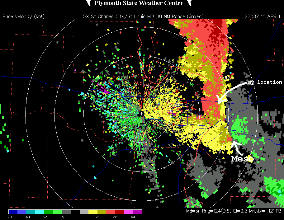
So, I blasted east to try to get ahead of the northward moving storm to my southeast. By around the time I got to I-55, this cell had gone tornado warned, with rotation indicated near Swansea moving northeast (probably NNE, actually) at 60 mph. Here is a velocity image from about the time the TOR warning was issued; the meso near Swansea is marked on the image (where the pink and green colors are juxtaposed, indicating wind form opposite directions), as well as my location where I took the pictures above and just before I began moving east and heard the TOR warning. Based on the reported position of the meso, I needed to get north to stay ahead of the storm and east to get into position to see the meso, and took I-55 to IL route 143, where I went east to the intersection with IL route 4. By the time I got there, I could see two lowerings to my southwest, only visible from the NNE through a narrow opening in the rain that was wrapped 3/4 of the way around the meso. The more northwesterly and solid of these two appeared to be the main meso/wall cloud that had led to the TOR warning - by now (around 5:25) located near Maryville. It also had what looked like the beginnings of an RFD slot, though it was not very pronounced. The two pictures below are of this storm, with the meso by the time I took these pictures located somewhere between Maryville and just southeast of Edwardsville:


Video capture, more zoomed, of the wall cloud of the tornado-warned storm.
All in all, not a bad first chase of the year. Although I saw no tornadoes, the storm structure was decent, and my chase strategies worked out pretty well for the storms that I chose to chase, although arguably I might have done better had I committed to the warm front despite the weaker storm parameters forecast for that area.