"The NAM, GFS, and RUC all agree on breaking out precip somewhere in northeast MO, southeast IA, and/or west-central IL during the 21Z-0Z period this afternoon/evening. Given that this is in an environment near the warm front with EHI better than 3, I think there is some potential for a supercell/tornado event if indeed any strong storms get going. The models vary quite a bit on where the convection might initialize, ranging from west of STL to southeast Iowa, but a good average might be somewhere in the area bounded by Kirksville, MO, Bowling Green, MO, and Quincy, IL. If we get some decent clearing in that area this afternoon, I will likely head that way for a look-see. I will be interested to see if SPC picks up on this area on the late morning convective outlook; so far they have not been impressed, but the model consistency on breaking out precip in this general area certainly has my attention."
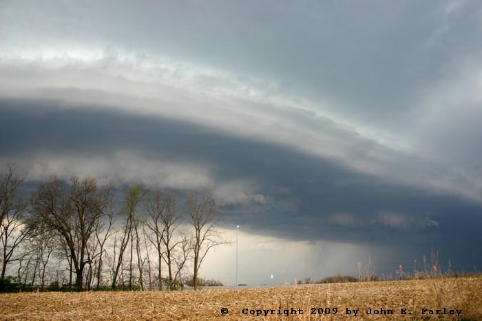
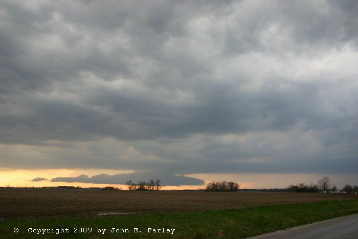
I headed out around 12:30 with an initial target of around the Hannibal-Quincy area. I figured I would go to Bowling Green or Hannibal, MO, check data, then refine the target from there. I knew that with the cap and the atmospheric moisture issues this could end up with a blue-sky bust, but storm observation opportunities have been limited this spring, and besides, I wanted to try out the new laptop auto power adapter I had bought for my computer to prevent losing radar halfway through the chase due to a dead computer battery. I hooked it up in Bowling Green and it worked great, but the only thing on the radar was light rain left over from the MCS in the Kansas City area the night before. This precipitation was located northwest of Quincy, near the IA-MO state line. However, I did see, both visibly and on the satellite image, a large field of growing cumulus just to my west, so I felt encouraged about that. I stopped to analyze data in Hannibal. By now, some new convection was forming just on the southern or southeast edge of the old precipitation area. The cumulus field was shifting eastward and looking a little less impressive, so I decided that any action would be with the new convection (which was just southwest of Keokuk) or under the cumulus field but not too far south of there. So I crossed the river and headed north through the Quincy area. The storms remained limited in area but continued to strengthen, so I planned an intercept just east of Keokuk. I ended up following one strong storm from Hamilton, IL eastward through Macomb, as the storm moved northeast but also backbuilt, giving it an effective ENE movement. I stopped between Carthage and Macomb and got some nice shelf cloud pictures:
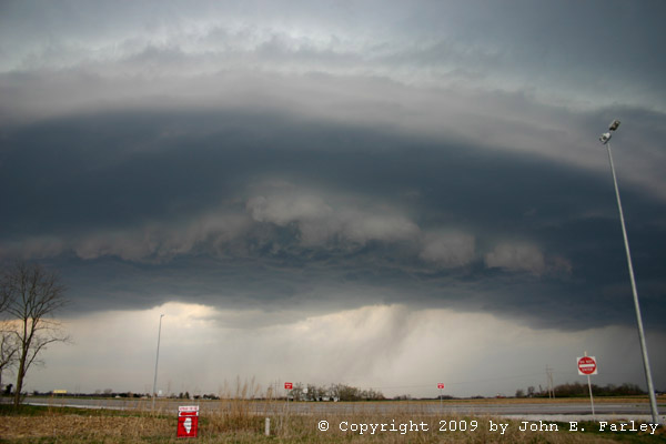
I took this picture just after driving through the south end of the line, where I encountered north or northwesterly outflow gusts of around 40 mph or a little stronger. However, when I took this picture, I was in the southeasterly inflow ahead of the line which I would estimate as gusting to around 35-40, a guess confirmed by a measured gust of 37 in Macomb ahead of the line. So, there was very strong convergence at the leading edge of the line. I stayed ahead of the line through Macomb, as heavy precip filled in behind the southern extent of the shelf cloud:
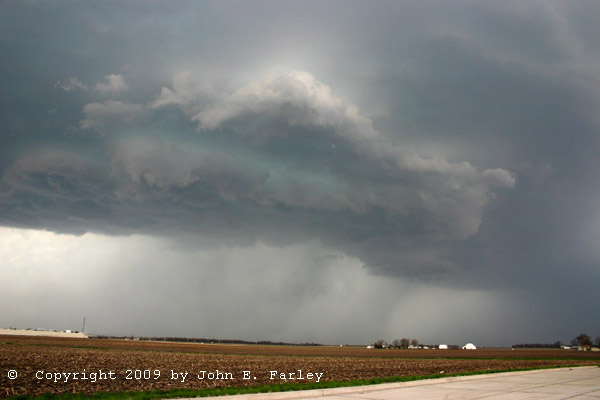
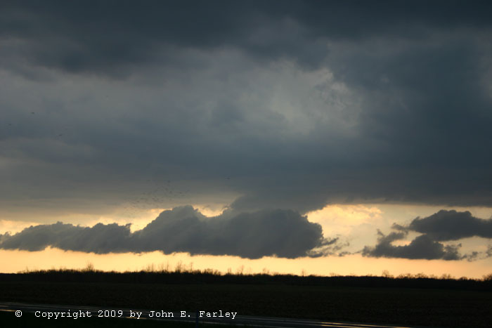
Just after taking this picture, I observed some weak cloud-base rotation for about 30 seconds, but it was gone by the time I could get the video camera going. The storm was not SVR-warned, but by now the DVN NWS office had put out a couple special weather statements mentioning strong wind and heavy rain, with second noting potential for gusts to 55 mph in the storm. Shortly later, however, I noticed that a new storm had popped up to the west near Keokuk, and the initial line of storms seemed to be weakening. In the distance I could see some kind of lowered area at th south end of the new storm, so I went back through Macomb and headed west. As I got closer, the lowered area came into view. It was elongated like a shelf cloud, but under the storm's main updraft like a wall cloud. However, on the continuum, I think it was clower to a shelf cloud as its cloud base movement was southward, driven by the outflow. I think this storm may have formed on an outflow boundary from the first one, but that was probably pretty close to the warm front. The surface air ahead of it, though, was quite cooled by the first storm, with a northeasterly breeze. In any case, the lowered area remained attached to the cloud base above it for most of the time I watched it, though sometimes only very narrowly. The cell showed up on radar as strong and isolated, and soon another special weather statement was issued on it for gusty winds and small hail. I briefly sampled a little of these at the southern edge, though there was only a little hail there, south of the main core. An interesting feature of this storm was the very slanted rain shafts, as the outflow from the storm was blowing to the south as the storm moved northeast. The northeasterly surface winds and southwesterly upper flow stretched the storm out considerably. Although I would not call the storm a supercell, the stretching effect gave it almost an LP appearance:

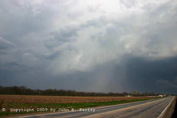
(This is my first try at creating a panoramic image using photomerge; while I didn't get the brightness identical I would say that it worked pretty well.) You can see the lowered area at the south end of the storm (left) and the very slanted precipitation shafts to the north (right). By now it was nearing 7:00 p.m., and the storm was getting away from me, so I called it a chase and headed back into Macomb yet again for a bite to eat before heading home. As I was heading east behind the storm, it formed what appeared to be a decent hail shaft, which corresponded to the strongest radar return on the storm:
Total chase distance: 437 miles.