
The chase:
1:45 - I see the first towers, well to my NW, heading north on route 183 around the Buffalo, OK area. Storms are initiating slightly W and SW of DDC, much like predicted by HRRR and RAP. I continue north where U.S. 183 turns into Kansas 34, as far as Bucklin, where I turn northwest on U.S. 400 toward Dodge City.
3:00 - In the Ford, KS area, I view a string of storms to my W. Three storms all seem to going up from the same elongated updraft base, but they are discrete and look supercellular on radar. A nice anvil is starting to backshear and also rapidly spreads east (downshear). Three storms are in the Dodge City (DDC) area, with the lead one having already produced 1.5 inch hail W of DDC. I hone in on the middle storm, now just SW of DDC, hereinafter called Supercell 1.
3:14-3:22 - Supercell 1 produces quarter to golfball-sized hail around the DDC area.
3:23 - I photograph rain and hail shafts over Dodge City. Still no pronounced lowering.
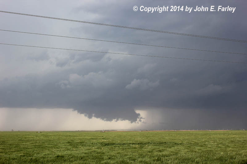
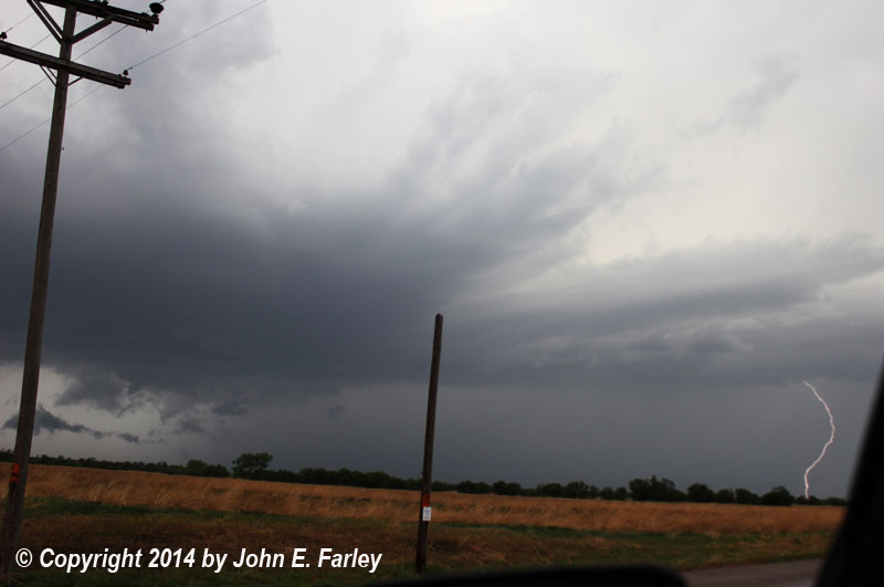
3:32 - A large wall cloud has formed. This is from north of Ford, looking west toward Dodge City. Occasional lightning zaps down:
3:36 - A scuddy lowering under the wall cloud is nearly to the ground. No rotation is visible.
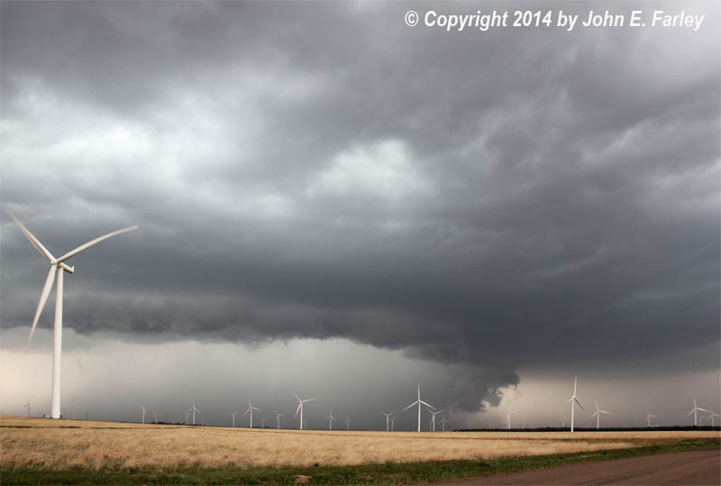
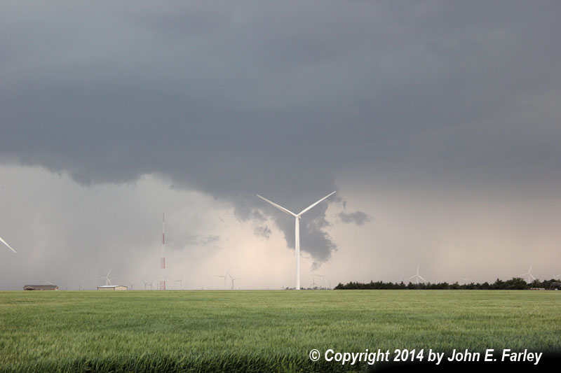
3:49-4:04 - I photograph the storm (still Supercell 1) and wall cloud through a wind farm south of Spearville. Always wanted to get a tornado with a wind farm in the foreground - didn't happen today, but it tried.
Another storm behind (SW of) Supercell 1 forms a wall cloud and drops 1-inch hail in the Dodge City area. This trailing storm is hereinafter called Supercell 2. Shortly after 4:00 p.m., the meso on Supercell 1 wraps up in rain:
4:20 - 4:30 - I am between Spearville and Kinsley on U.S. 56/50 observing Supercell 2. It looks HP and outflowish, but after a while develops a menacing wall cloud at the north end of RFD gust front, at a convergence of inflow and outflow. So far the entire time I have been in inflow; no outflow has reached me. Supercell 2 now appears to be overtaking Supercell 1.
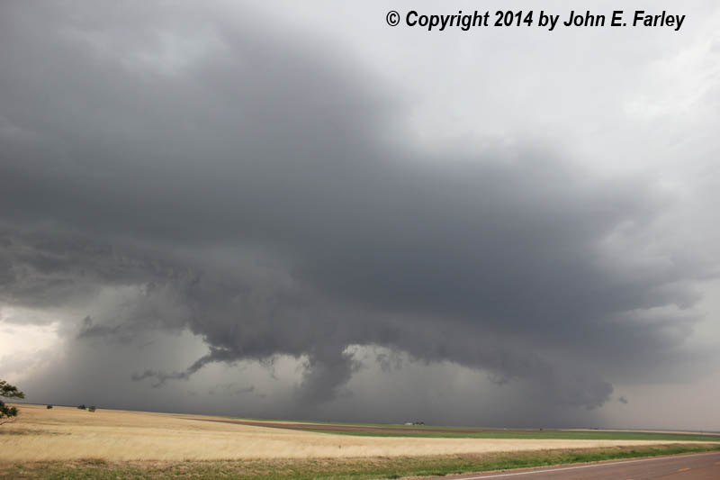
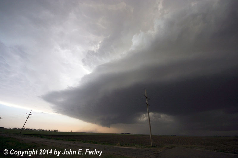
4:55 to 5:05 - As I head northeast then north from Kinsley on route 183, Supercell 2 appears to have overtaken Supercell 1, with the two storms effectively merged. Intensification occurs, with spectacular storm structure and menacing lowerings. Golfball hail is reported N of Acres and around Rozel, covering the ground in some areas between 4:55 and 5:00. Here are a couple pictures of this storm taken around this time:
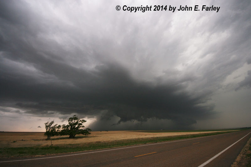
Wide-angle shot showing the whole storm - one of my favorite pics from this chase!
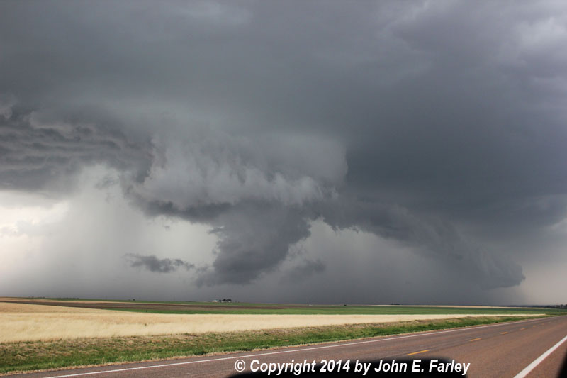
A more zoomed view as the storm continues to intensify
After I watch a little longer, 3-inch hail is reported as storm crosses the road (route 183) ahead of me N of Sanford; I am a little S of Sanford.
At this point, I know I can no longer keep up with this storm, which is dropping giant hail directly to my north. Other SVR-warned storms are approaching from the SW, having also passed through the DDC area. Also ahead of the line of supercells is one lone supercell. I think this might be the better play because it is more isolated, but intercepting it might be difficult as it is moving more to the right, on a track to my SE. I break off Supercell 2 and stairstep east and south, through Garfield, to try to intercept the storm ahead of the line.
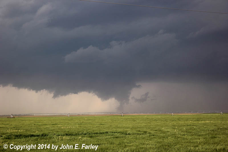
5:30 - I am several miles S of Garfield. Dubious about intercepting the SE storm, which looks LP-ish and is tracking on a path to my SE, but the next supercell in the line, to my SW, has a very impressive wall cloud. I decide to stay there and watch this storm (Supercell 3).
On radar I see that immediately to the W or WSW of Supercell 3 is another impressive storm (hereinafter, Supercell 4). ATTM I cannot see this storm visually, so I decide to adjust a little south then west so I can see both Supercell 3 and Supercell 4. Both storms develop radar-indicated mesos.
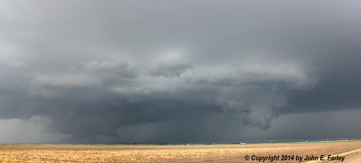
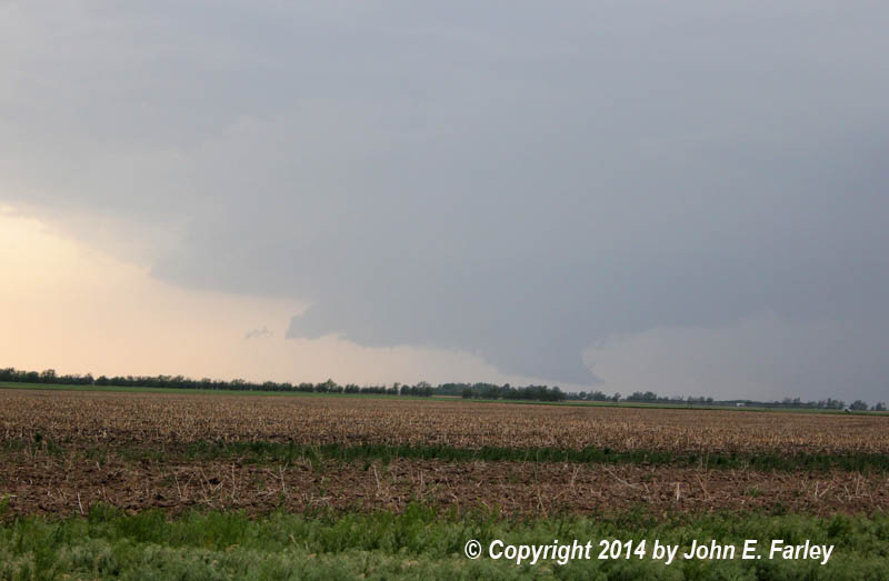
5:56 - I am in position to see both Supercell 3 and Supercell 4. Both have wall clouds, and they appear to be merging. Here is a panorama picture that shows both wall clouds:
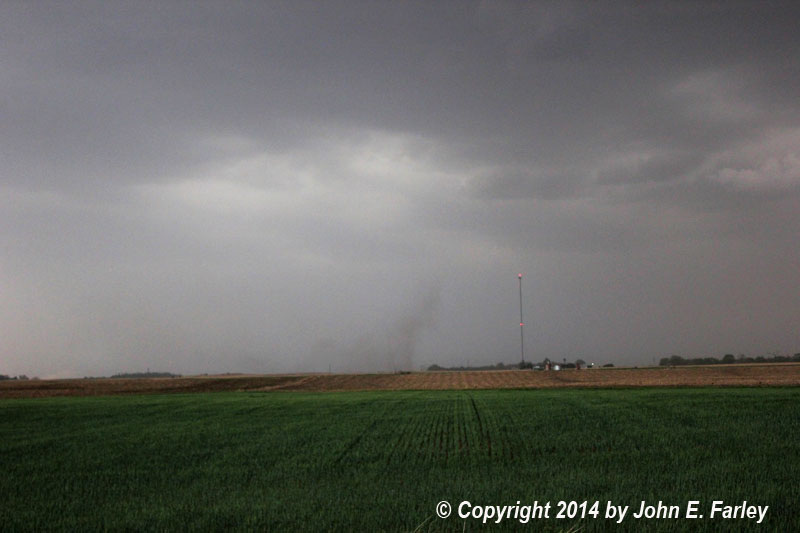
6:00 - A funnel extends halfway to the ground from the side of the wall cloud of Supercell 4. I could not confirm ground contact but there could have been. Duration is about 2 minutes before the funnel ropes out and disappears; I have 72 seconds of video in 2 segments. Here is a video capture of the funnel cloud:
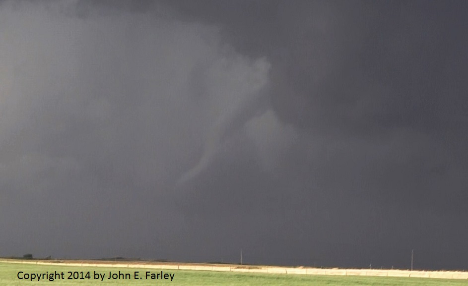
Video of the funnel cloud can be seen here.
6:05-6:07 - Wall cloud of Supercell 3 shows signs of rapid intensification and rotates as Supercell 4 is getting absorbed into Supercell 3.
6:10 - Supercells 3 and 4 have merged as rain wraps across and blocks my view of the meso. Tornado warning is issued based on rotation near Garfield. I am 4 or 5 miles S. of Garfield and decide to head up to route 56 which runs NE and SW to regain postion on the storm.
6:12 - A chaser reports a tornado between Garfield and Frizell. I am just to the SW of the tornadic circulation, trying to reposition. My view is blocked by rain.
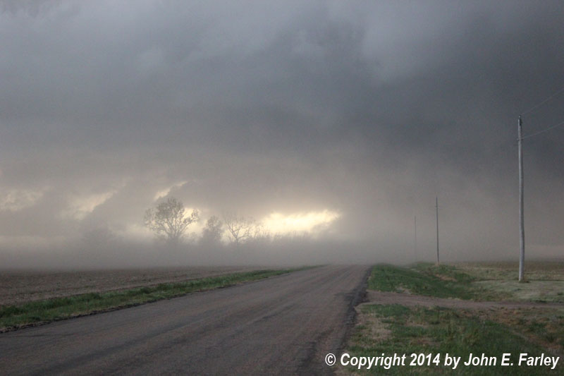
6:20 - 6:25 - I am repositioned just SW of Larned on route 56. I videotape circulation emerging from rain just to the W of Larned, with Larned sirens blaring. Radar indicates possibly tornadic circulation near Larned. I see large rotating cloud mass near the ground; I was not sure if it was still down or not. However, after reviewing pictures and video from other observers and seeing a newspaper report of damage to some farm buildings roughly where this feature passed over, I have virtually no doubt that this was indeed a tornado. I am not completely sure whether it was a continuation of the tornado between Garfield and Frizell or a new touchdown (more likely the former, though), but it certainly was the same circulation. Here is a video capture of the tornado, looking north from a couple miles southwest of Larned:

Video of the tornado can be seen here. After a minute or so it dissipates and Larned appears safe, though I heard the sirens sounded 3 times between about 6:20 and 6:30. Also at 6:20, 2.25 inch hail is reported between Larned and Ash Valley.
6:30-6:40 - As sirens blare for the 2nd and 3rd times, I drive through Larned and a few miles to the north to see if there is any damage. I see none. Turns out I was looking in the wrong place; I was a little farther SW of town than I had thought when I was looking N, and the damage was west, not north, of town.
6:45-7 - I notice another supercell (Supercell 5) passing to the northwest and stop to watch it and try to get some lightning shots from a spot 3 miles or so north of Larned. This storm produced 1-inch hail around Rozel and Seward, and was quite electrified for a while. But I only got one decent lightning shot. This storm had a lowering that looked like it could have been a funnel, but I was way to far away to tell. After this I headed south back through Larned on route 19.
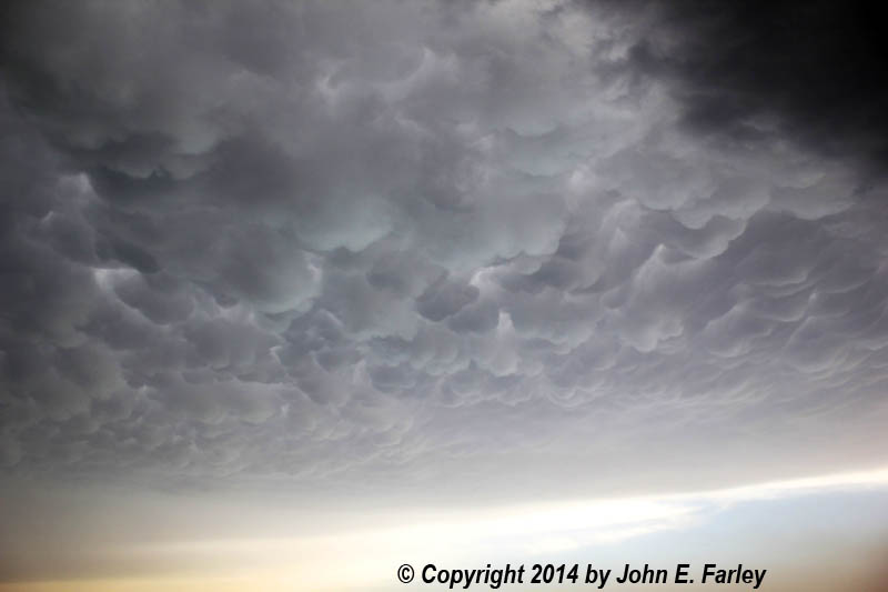
7:15-7:30 - Radar shows yet another strong storm coming up route 56 from the Kinsley area. A tornado was reported west of Kinsley at 6:46 p.m. and a hurricane-force wind gust was reported near Kinsley at 7:35. Not sure if these were both from this storm, but probably at least one of them was. I have headed south from Larned to get a view of this storm and to get out of its path. Around 7:20 I get a nice picture of mammatus overspreading the sky under this storm's anvil. As this storm (Supercell 6) approaches, I see a lot of dust getting kicked up in the distance by its RFD. A wide-angle shot of this storm with the dust plume can be seen here. This was looking SW from near Belpre.
7:30-7:45 - I cross in front of the gust front of this storm, seeing lots of blowing dust (some with inflow, more with outflow) and at least 1 gustnado. Can't video the gustnado because, although my vidcam battery was fully charged when I started, I have now run it dead. At least I got a picture!
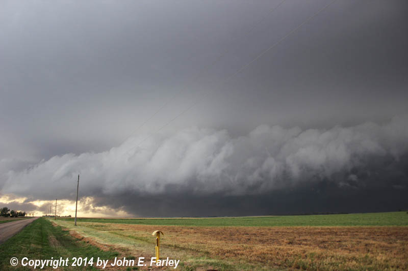
7:45-8 - After briefly being in the RFD outflow of Supercell 6, I am back in inflow. I turn west at the T intersection near Trousdale. Now the cold front is catching up to the dryline, and and the storms are finally lining out after remaning mainly discreet, albeit with mergers, for 6 hours. An impressive shelf cloud is surging toward me, but I am back in intense inflow, and see another gustnado around 6:50 to my NW where the inflow and outflow are meeting. Shortly thereafter I am slammed with the outflow and blowing dust reduces visibility to near zero. Conservatively I would estimate the wind around 50-60 mph, but it may have been more - there was a report of a 70 mph gust a little to my north around 7:50 p.m. Here is a picture of the blowing dust ad the most intense of the outflow passes my position:
I wait for the worst to pass then head west to route 183. Very strange visibility effect at this time between the gusty outflow and the precip area - it is almost as dark as night due to the thick clouds, but right in front me is a narrow band of rain and hail backlit by the sun. Between the darkness and the rather bright backlighting straight ahead, it is nearly impossible to see the side of the road.
8-8:10 - After a while I get to route 183 and the precip overtakes me, with additional gusty wind, heavy rain, and hailstones with a few up to an inch in diameter around 8:05, though majority are smaller. I stop for a minute, then checking radar realize I can run out of it going north into Kinsley, which I do. Though the storms were linear now, radar suggested a nasty hail core from just south of my location down through Greensburg, which verified with a report of golfball hail in Greensburg. Also around this time there was a second report of hurricane-force wind in the Kinsley area, with powerlines down. When I drove throught town around 8:10, I noticed lots of small branches down.
Return to 2014 Severe Weather Observation page