Low pressure was forecast to be positioned in northeast NM or southwest CO with a warm front eastward near the KS/OK boundary and a dryline southward somewhere near the NM/TX boundary. Good wind shear was expected (although as the time of the event drew closer, models began to raise some doubt about low-level shear). CAPE was predicted to be in the 2000+ range a couple days ahead, but this, too, backed off somewhat to between 1000 and 2000 as the day of the event drew closer.
Morning forecast - The previous day's storms, which I had chased in New Mexico, occured farther west than forecast over north central NM, between a dryline in an unusually west position near or just west of the central mountains of NM, and cool air that was behind a stalled backdoor cold front over eastern NM. That cool air had still, by the morning of this day's event, not really cleared out of eastern NM or the Panhandles. Instead, cloudy, cool temps persisted across the Panhandles and eastern NM in morning, questioning how unstable it would get and how far east storms would form. The models did predict some destabilization with CAPE reaching and likely exceeding 1000 in the Panhandles ahead of the dryline, which would extend S/SE from the low in northeastern NM into the western TX Panhandle. The models again also showed storms mainly in the northern part of the target area, initiating in northeast NM, southeast CO, or the far northwest part of the Panhandles. Not much action was forecast anywhere near I-40 by 0Z, including on the HRRR, which had been very accurate the previous day in keeping the NM storms north of I-40. The morning forecast discussion from the Amarillo National Weather Service focused mainly on the northeastern parts of Panhadnle, east of a Guymon-Stinnet-Shamrock line, which seemed too far east to me. I decided to head to Dalhart from my overnight stop in Tucumcari, NM, get there by lunch time, and then I could shift east or north if I needed to.
I arrived in Dalhart and had lunch. The town was a mess with construction and flooding from heavy rain overnight and in the recent past. Checking data, I noticed a couple small storms in northeast NM and southeast CO. I watched radar for a while and the two storms strengthened on radar. One was in southeast CO a little south or (at first) SE of Kim, and the other was WSW of Clayton, NM. I decided these were the sotrms to go after a little before 2:00 p.m. CDT - I was probably somewhere around 70 or 80 miles from them at that time - so headed up from Dalhart to Clayton on US 87 and then north of Clayton on NM 406. Although the storms were reported and marked on radar as moving NE, they really were not moving much at all, particularly the CO one, and if anything it was drifting slowly south. A total of 4 SVR warnings were issued for far southeast CO starting at 12:38 MDT and continuing until the last one was issued at 2:08 MDT, then at 1:40 MDT (2:40 CDT) a SVR was issued for the NE corner of NM.
Supercell 1:
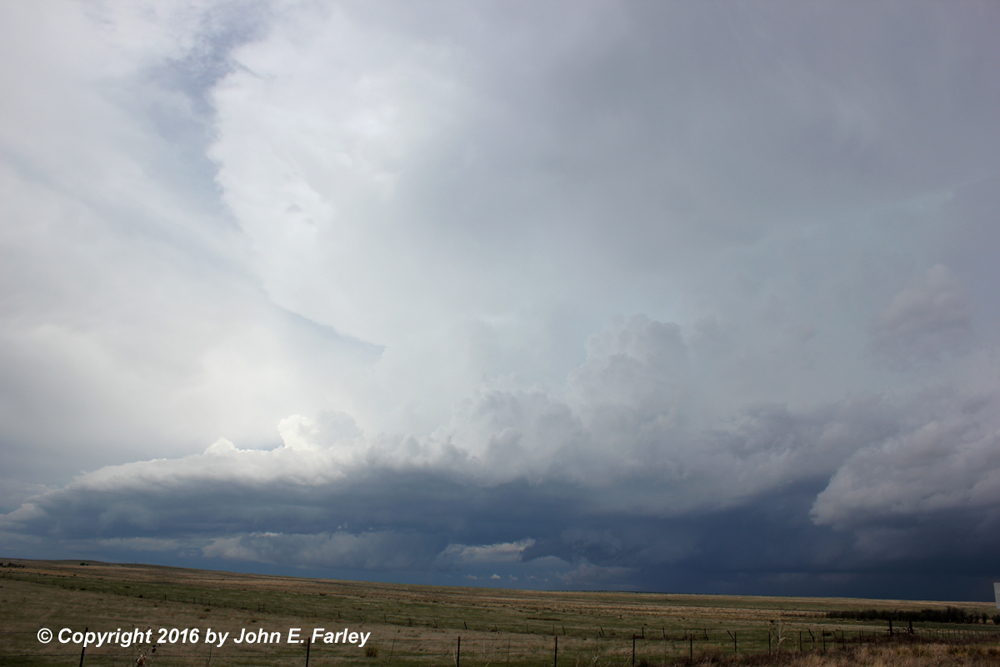
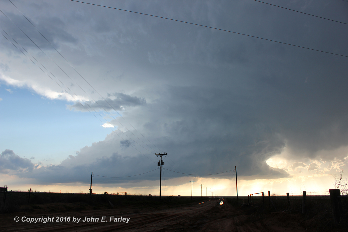
When I got to Clayton, NM, there had been multiple SVR warnings on the storm north of there, and none on the storm to the WSW of there. Hence, I decided to go for the northern storm, figuring that as slow as they were moving, I could always double back to the southwestern one if that looked better. By sometime around 2 MDT/3 CDT, I was far enough up NM 406 north of Clayton to have a good view of the supercell. It indeed looked menacing, though not imminently tornadic, with a nicely backsheared anvil:
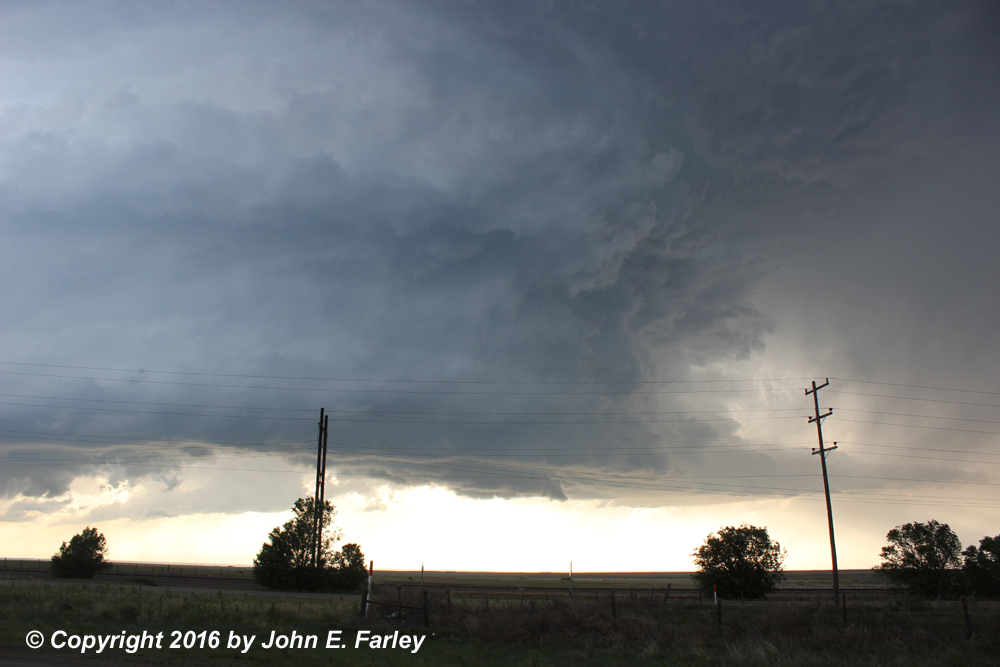
At this time, the storm was moving very little, remaining about 25 miles or so north of Clayton. The backbuilding process seemed to be offsetting the slow northeastward drift of the storm, so it ended up staying in about the same place for an hour or so - I did not have to move much to watch it. That is fortunate because I had no data, as is often the case in very rural parts of New Mexico. Around 15 miles north of Clayton, I turned off 406 on the gravel road that goes west to a Santa Fe Trail historic site, watched the storm there for a while with a handful of other chasers (including at least one tour group), then I drifted east and north on 406 to get to a high spot to view the storm. Gradually the slow-moving storm seemed to be geting more HP in character, and finally by a little before 3 MDT the storm seemed to be starting to move toward the S or SSE a little more. 1.25" hail was reported NNE of Moses, which was a little to the NNE of my northernmost point. But by 3:00 the storm was clearly moving to the S or SSE and I needed to move south to stay out of the hail, which the storm definitely had the appearance of producing when I took this picture just after 3:00 p.m. MDT:

I needed to head back south on NM 406 to stay out of the way of the storm, which is what I did. I also wanted to get back to Clayton so I could get data again. I knew that when I got to U.S. 56/64 just NE of Clayton I would need to make a decision - either head ENE on 56/54 to re-intercept the storm (Supercell 1), or head south or west to intercept the other storm, which had gradually intensified and now looked good on radar (once I got it back), and only drifted moderately clower to Clayton (maybe 10 mi WSW of there now, compared to 30 mi. WSW an hour and a half or two hours ago). By the time I got to 56/64, the storm I had been on north of Clayton (Supercell 1) seemed to be looking less organized, and increasingly HP. So I made the decision to head into Clayton and try to position myself on the next supercell to the southwest. This made sense to me because 1) this was now the tail-end storm, so would seem to have the less contaminated inflow and 2) the base of the storm was nicely backlit and easily visible, in contrast to the increasingly HP character of the storm I had originally been on. Naturally about the time I was going through Clayton I saw a TOR warning for a confirmed tornado on the storm I had just left. Arrgh!
Supercell 2:
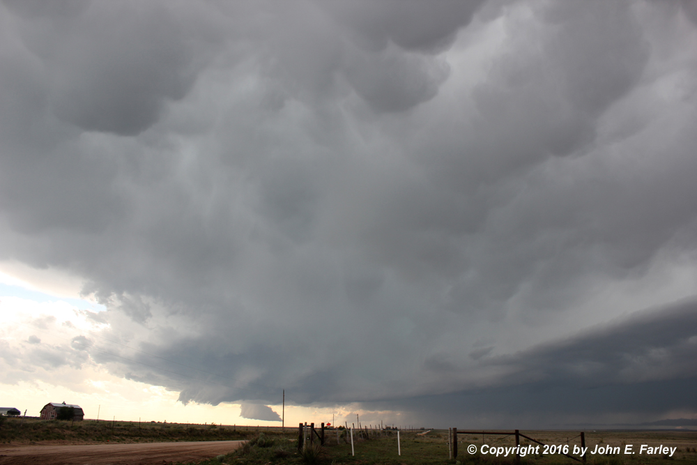
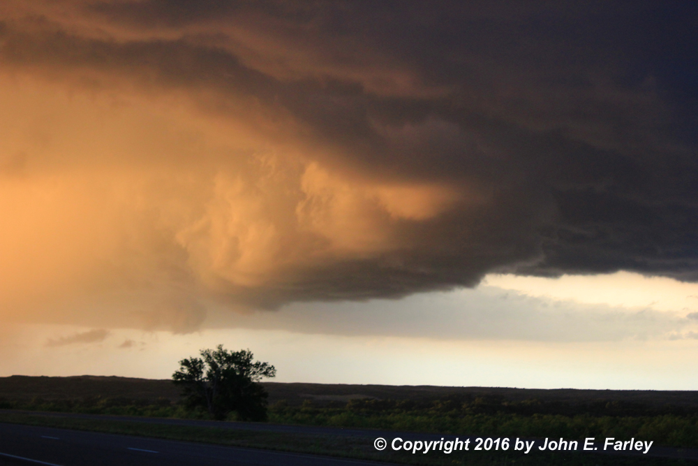
Figuring that a tornado in the first storm could be rain-wrapped, I stuck with my plan of going after the next storm down. (Indeed the two tornadoes that the storm I had just left produced as it moved into the OK Panhandle were rain-wrapped, but some chasers managed to get views of them with only minimal rain. They were rather low-contrast, but still clearly tornadoes, so congrats to the chasers who stuck with that storm longer than I did.) Radar suggested that the storm I was now going after, like the one I had just left, had changed its original motion (in this case, a slow drift to the NE) to a somewhat faster motion to the ESE. I did not think I could avoid getting overrun by it if I headed WSW out of Clayton on US 56, so I returned to the ESE toward Dalhart on US 87, with a turn or two onto side roads to view the storm. When I crossed back into TX at Texline, I briefly flirted with going east to try to re-intercept the orginal storm I had been on, but quickly realized I would be too far south of the storm to see anything. So I poked a little south and west of Texline on roads to the SW of 87, then as the storm drew closer, I returned to 87 to stay ahead of it. On one of the side roads long 87 I noticed (around 5 p.m. CDT) that the storm I was now targeting had formed a rather large and nicely backlit wall cloud, with some rather impressie mammatus above it:

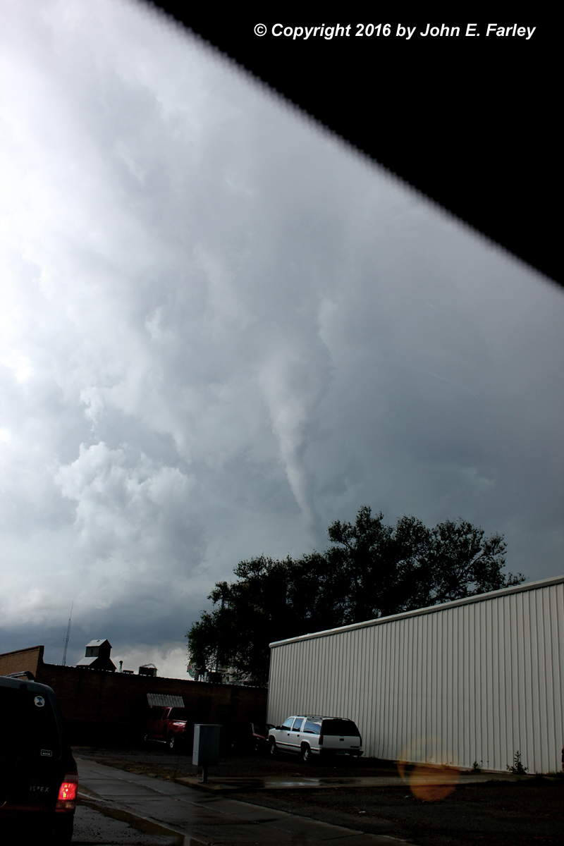
At the times these pictures were taken, the storm was still in NM, but it was soon to cross into TX and its ESE movement appeared likely to take it across 87 somewhere a little NW of Dalhart. After continuing farther SE on 87, enough to be ahead of the storm, I decided to poke closer to the storm again on a paved road I came across, not sure what road it was. As I drew closer to the storm again, I began to get a little rain and hail out of the core to my northwest, but also noticed a lowered area under the wall cloud. At first it had a bit of a bulbous appearance, but it rapidly evolved into what was clearly a funnel cloud, with the condensation soon stretching toward, though not all the way to, the ground. This was around 5:40 p.m. CDT. Though the condensation did not quite reach the ground, I knew it could be a tornado, and indeed that is what it turned out to be: A storm survey by NWS Amarillo confirmed that it was an EF-1 tornado. While I was not sure about ground circulation, other very experienced chasers who were closer to it were, and in fact, per the damage survey, it destroyed a grain silo, flipped a pivot irrigation system, and caused tree damage and minor damage to a farmhouse. From my location the tornado was beautifully backlit, and this high-contrast tornado (though at the time I was only sure it was a funnel cloud) made me end any regret I had about leaving the earlier tornadic storm I had been on. Here are three video captures, in time order, of this tornado, which occured between 5:40 and 5:42 CDT:

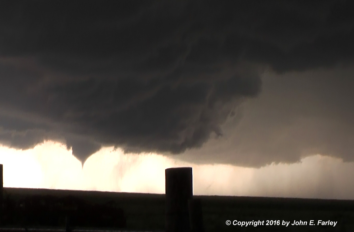
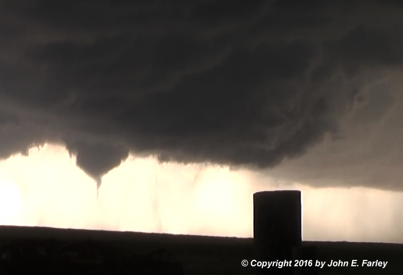
In the third picture, there does appear to be a dust swirl under the condensation funnel, though I was not sure at the time. The video, linked below, appears to confirm this. I am very pleased to have captured such a nice, high-contrast tornado, and this was my first Texas tornado. At the time I was not sure whether it was in NM, TX, or both, but the damage survey confirms that the tornado occurred just inside Texas, beginning 16 mi. south of Texline and, after being on the ground for just under a mile, ended 16 mi SSE of Texline.
Below is my video of the tornado - sorry it is a little shaky but I could not get out and tripod due to rain and hail falling and CG lightning in the area.
After the brief tornado was over, my challenge was to remain in position for a good view of this storm without getting overrun by the meso or by the large hail I knew was just to my north/west. Indeed, golfball hail was reported not far from the location of the tornado. But I was lucky, being able to follow paved roads south and east that eventually got me back to route 87, still just ahead of the storm. I continued SE on 87 to Dalhart, hoping to be able to find a way to avoid the big construction jam I had seen in town earlier and get through town before the storm arrived. But that was not to be. I turned left, following some locals, to try to avoid the massive jam, but it turns out that railroad tracks pretty much divide the town in two and the only way through was where the big construction jam was. Meanwhile, the hail core was now just barely to my north, and any attempt to detour east beyond a half mile or so would put me squarely in it. Rain and hail began to increase, so I finally made the decision to park under a roof I had seen at an old grain mill and wait out the worst of it. At this location the hail did not exceed an inch or so in diameter, probably smaller, which was good since it was coming down at a 45 degree angle so the roof was only of limited benefit. When it let up I tried to get back west to 87, but the traffic on the side street was equally backed up with people trying to turn left into the jam to get through town. After 5 minutes or so in the jam, I noticed this through my windshield, around 6:36 p.m. CDT, not too far to my NW:
Sure looked like a funnel to me, although I could not ascertain rotation. Thinking about it a little, I think it probably was a mid-level funnel from its appearance. Although there were no warnings or, for that matter, chaser reports about it, it turns out there was a second tornado about a half hour before I got this picture, around 15 miles WNW of Dalhart, so I wonder if this might be some remnant of that tornado, or perhaps just an entirely separate mid-level funnel. So far as I can tell, very few chasers saw this feature because most of them were in the traffic jam looking away from it, but since I was facing west I was in a postion to see it. Knowing that it was moving pretty much directly toward me, I was a little nervous, though I doubted it was down. However, I prepared myself to make a U turn and mad dash to the east if I had to. However, it gradually seemed to fade and disappear in the rain, and fortunately did not have any impact on Dalhart. If it had, it could have been bad with all those people stuck in the construction jam.
Supercell 3:
Once I finally got south of Dalhart, probably somewhere around 7 p.m. CDT, new storms were again firing to the west, so I decided to continue on 87 and see what I could see of these storms. When I got to Hartley, I continued SSE on U.S. 385 rather than staying on 87 where it turns east there, because the more southward route would keep me closer to the storms. Soon, by around 7:20 p.m. CDT, a gorgeous LP supercell developed a little to my west, the second consecutive day I was able to witness a storm of this type, certainly one of the most spectacular storm types there is:
Storms of this type do not look like they are producing much precipitation, partly because the upper winds are carrying the rain farther from the updraft than usual, and partly because although they may not be producing a great deal of rain, they do produce hail, which is less visible as it falls than rain. Sometimes very large hail, as was the case with this storm. Here is another picture of the storm as it drew closer:
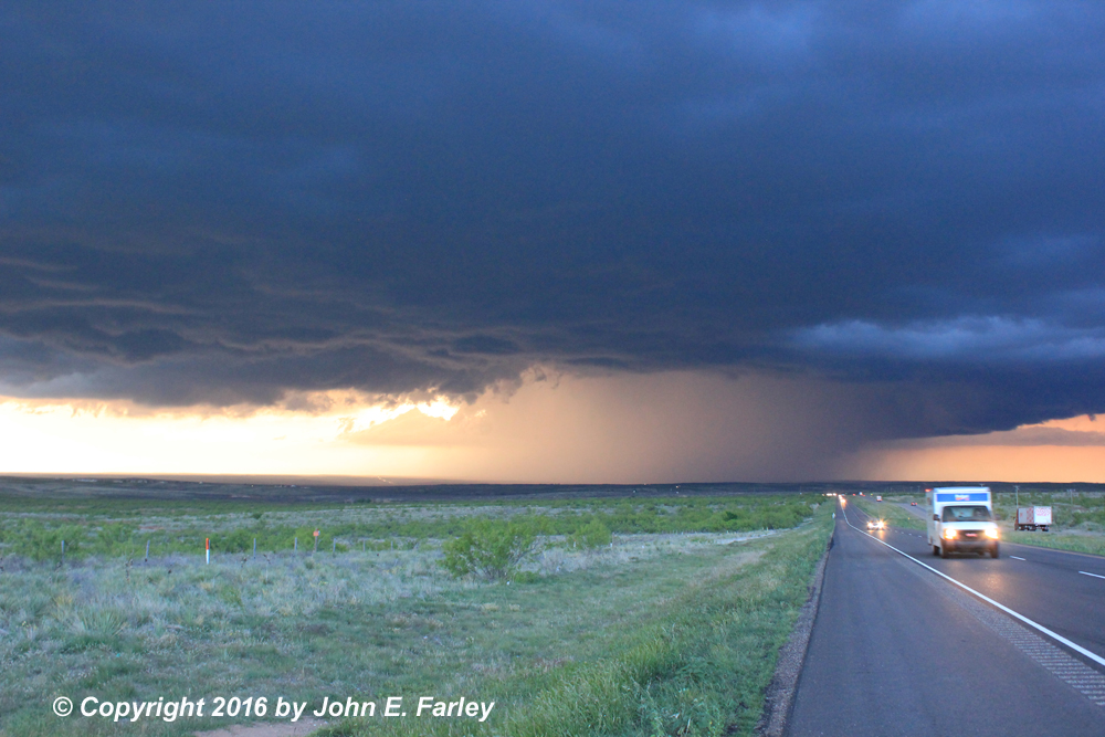
The whole storm was rotating slowly, and the radar confirmed that, regardless of its appearance of not much precipitation, there was plenty, much of it likely hail. When I got to Channing the storm was very near and I knew I needed to get east on route 354 to try to get back ahead of it. There were now lots of other chasers on this storm, the most I had seen all day. Soon the chasers became the chased, as the storm moved ESE with large hail right behind (and in some cases into) the chasers. I got ahead of it enough to stop for pictures a couple times, but the storm was moving faster now than earlier and it was not possible to stop for very long. At one point I noticed numerous chasers fleeing east and figured the hail must be very close. Sure enough, as I headed east, I heard several rather loud bonks as one hailstone, then another, hit somewhere on my car. They were not huge, but they were larger than any others I had encountered this day; I would estimate somewhere from quarter-sized to possibly golfball, but most likely in the 1.25-1.5 inch range. Hail reports of golfball size came in from a number of places around Channing. But I was able to get ahead of the storm and, when I got to 87/287, turn to the SSE toward Amarillo. As I did and the storm moved toward 87, reports began to come in of hail in the 2+ inch range, with eventually multiple reports of 3-inch hail. Some chaser vehicles were damaged, but luckily I was able to stay ahead of it. As sunset approached, the rain began to wrap around the storm's wall cloud and it transitioned to more of an HP strucutre, as can be seen in these two pictures taken along the highway north of Amarillo:
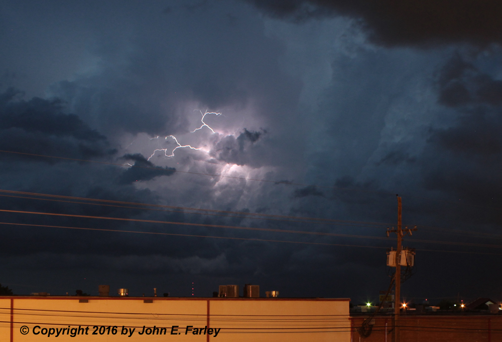
I got into Amarillo and found a place to stay for the night, as the storm passed NE of town and producted a spectacular lightning display:
I celebrated the day's successful chase with a late but delicious steak dinner at Saltgrass Steak House.
A list of local storm reports for these storms from NWS Amarillo can be found here.
Return to 2016 Severe Weather Observation page