Stayed the night before in Liberal KS, working my way east for a multi-day chase. Felt the chance of supercells would be excellent, with some chance of tornadoes, in southwest KS. The atmosphere was forecast by several models to be extremely unstable, with CAPE in the 4000-5000 range. The wind profile would have turning with height in this area, although there was a bit of a back-veer-back profile with height during the day, which is not quite so favorable for tornadoes - but that was forecast to largely disappear by evening. Another concern was that in the very lowest levels, there was a little less turning than farther up. Also the LCL was a little high for tornadoes, meaning that the storms could be high-based. But overall, with such extreme instability, supercells appeared to be a near certainty, with the chance for tornadoes increasing around sunset and, unfortunately, after dark as the lower-level jet would begin to kick in. Several days earlier, it had appeared that a cap - a layer of warm air aloft - might keep storms from forming, but by now all the models were suggesting this would not be the case, with all of them breaking out precipitation somewhere in the general target area.
By the next morning, it appeared that the aforementioned concerns with the wind profile would not be an issue - the models were showing the wind gradually shifting from southeast at the surface level to southwest up high - the kind of turning that is favorable for rotating thunderstorms. The wind fields were not terribly strong, but if in fact the instability would be as great as had been forecast, that would not matter. But a new forecast concern did arise in the short-range models (RAP and HRRR). These models were showing an intrusion of drier, more stable air across the dryline into southwest Kansas, with the most unstable air being pushed back a bit farther northeast. I was not sure if this was due to convective feedback in the models or a real intrusion of drier air. If the latter, it could reduce the chance of seeing strong storms, and/or, at the least, push the target area northeast more into central Kansas. I decided to head east to somewhere around Sitka or Protection, KS, and then re-figure from there. By the time I got into those areas in the very early afternoon, the SPC Mesoscale Analysis page was showing that my concerns were to some degree verifying. Drier, more stable air did seem to be pushing in, and the dryline looked to be shifting a bit farther east than forecast. Both the trough that was driving this weather system and the dryline itself had a bit of a negative tilt, i.e. they were alligned NNW to SSE. So it was clear that I would have to go farther north and maybe a bit farther east than I had originally figured on. I revised my target to Greensburg, and figured I might even have to go north or east of there. The dryline mixing I was concerned about did also seem to be happening to some extent, with CAPE in some areas of SW KS even east of the dryline only around 2000 - still unstable, but not the explosive instability that had been forecast. Other areas to the north, east, and even south were much more unstable, but storms were unlikely too far east of the dryline and the north and south options would be a long drive.
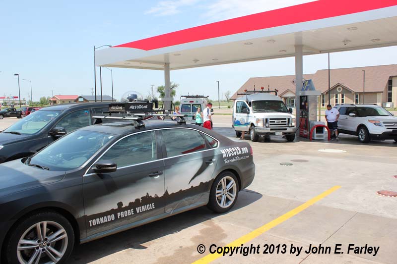
I gassed up for the active phase of the chase, got a snack, and checked data in Greensburg around 2 p.m. or so. It was great to see lots of chasers spending money in Greensburg, a town that was devastated by a tornado several years ago. The gas station and convenience store I stopped at was jammed with chasers, including two vans from the College of DuPage in Illinois. The short-term models were now showing a renewed surge of more unstable air northward along the dryline from OK, although the most unstable air looked to remain just north and northeast of my position. But there would be sufficient instability for severe storms just about anywhere along the dryline, and I liked the directional wind shear from around my location north. If a storm could get into sufficiently unstable air in this environment, it should rotate and could produce a tornado.
The Chase:
By 3 p.m. or so, storms were firing to the north and northwest of Greensburg along the dryline. I started for a storm that began to look good off to the northwest, but didn't go far before realizing that trying to catch up with a storm moving NNE from three or four counties south would not likely be a winning proposition. I wandered back and forth a bit on route 54 west of Greensburg and 183 north of there before finally deciding to head north toward Kinsley and try to intercept storms that were forming southwest of Kinsley and well to the west of Greensburg. Unfortunately from a chase standpoint, though, these "storms" were weak and high-based, with very little precipitation and in some cases no lightning. They were obviously still in the area of dry air intrusion and high LCL (condensation level). That would eventually change, however. Here is a time-by-time account of the rest of the day's chase, which would turn out to be my best ever.
4 p.m. - I am watching attempts at convection west/SW of Kinsley. The convection continues to be high-based, with little precip, seen either visually or on radar.
4:30 - Still similar conditons, as small, high-based showers and storms are forming, but either failing to strengthen or fizzling out entirely. By now the storms off to my northwest are producing 2-inch hail, and some of them are starting to get tornado warnings. But I knew that racing way north and trying to catch up to them would not be a winning proposition. I have moved to just east of Kinsley and am looking SW at the weak, high-based convection.
4:50 - I am heading south from Kinsley. I think about switching to a more southern storm (or actually, cluster of storms) coming out of OK, which are now starting to get SVR warnings. But I am also watching some updraft base west of Greensburg that is better-looking than what I have been seeing on the earlier storms.
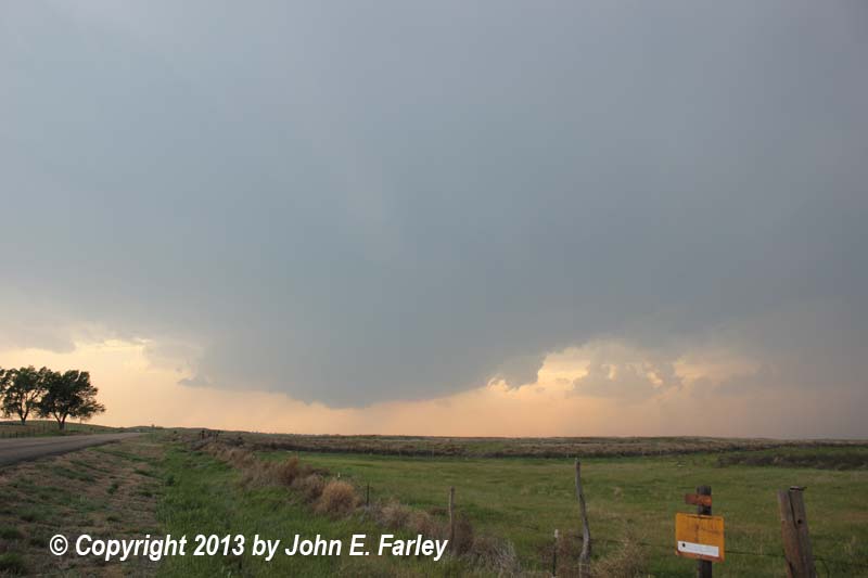
5:20 - I am watching a storm that formed W of Greensburg from the updraft base mentioned above. This storm is now about due west of my position a couple miles SW of where 183 jogs left going S from Kinsley. The base looks good, and radar shows the storm strengthening. There is some, but not a lot, of precip visible looking W and NW from my location. There is also increasing lightning, mostly but not all in-cloud. From 5:20 to 6:20, I work my way north toward Kinsley as this storm drifts to the NNE and slowly strengthens, and eventually develops a broad lowered area under updraft. The storm was still small, though, and the storms to the south continue to get SVR warnings. I came within a hair of leaving my storm to head south to intercept the storms coming out of OK. Actually started to do so a time or two, but each time I thought, this storm does look pretty good and it is isolated. And I remembered the "don't leave fish for fish" comment that a fishing friend of one of my fellow stormchasers had made on facebook a day or two earlier. So each time I started to leave, I decided instead to stay on the storm, and I am very glad I did. At 6:19 p.m. a SVR warning was issued for this storm, confirming that staying with this storm was just as good as backtracking toward the increasingly messy-looking cluster of storms to the south with similar warnings.
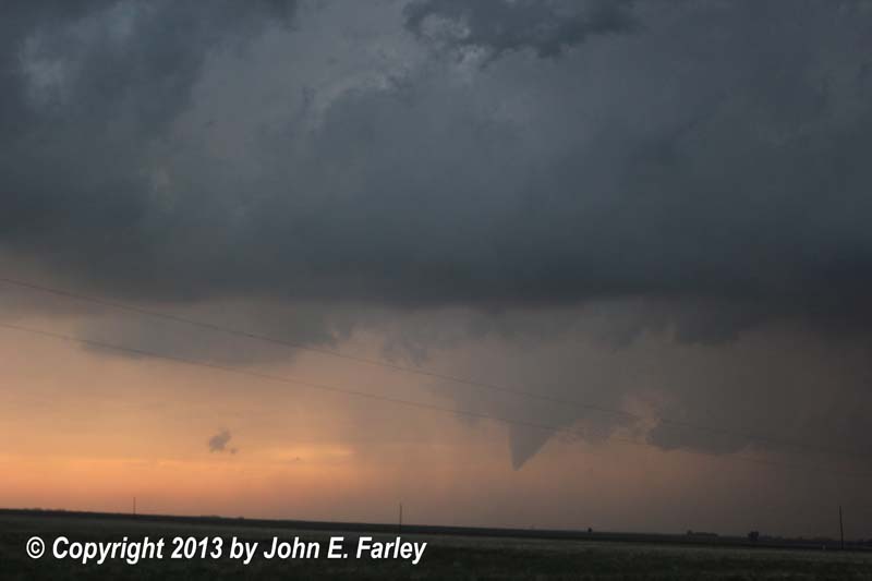
6:20-6:25 - A very thin, high-based funnel forms under the updraft base, just ahead of wall cloud, and persists for about 5 minutes. There may have also have been a small funnel on the far (southwest) edge of the wall cloud, but I am not as sure about the latter. I get pictures and video of the funnel. It never came close enough to the ground to pose a serious tornado threat, but it suggested to me that the storm might be capable of more. The storm to its north had produced a couple of tornadoes, and this storm was gradually moving into that environment.
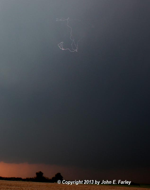
6:45-7:05 - I head NE and eventually N on 183 from Kinsley. I get my one and only success with my camera lightning trigger on this trip - in this case, it was in-cloud lightning - quite an interesting image, as the lightning just seemed to run ramdomly around in a small area of the cloud. Two women on their way to Dodge City ask me why so many people are stopped; I explain about storm chasers, show them radar, and assure them that they will be OK going to Dodge, as they will pass between storms. At this point, the storm doesn't really seem to be strengthening and I am thinking that my catch for the day might consist of the earlier funnel, an interesting storm, and maybe some lightning. But the storm is isolated and the SVR warning was re-issued when the old one expired at 7, so no reason to leave the storm.
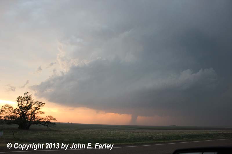
7:11 - I again start videotaping as the storm's wall cloud becomes more pronounced and shows signs of rotation. There is also rapid upward motion on front edge of wall cloud. Soon, the rotation becomes quite pronounced, and by 7:15 or so, a definite funnel cloud has formed.
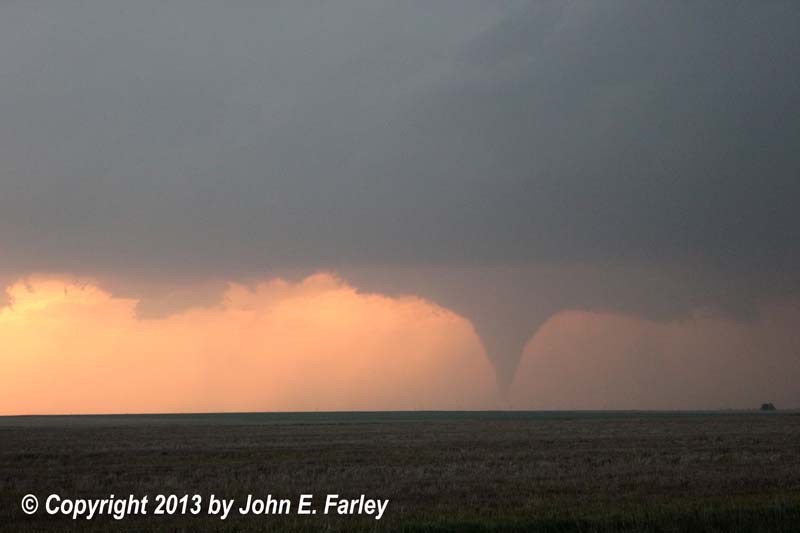
7:18 - The Rozel, KS tornado begins. I am not sure at first whether it is a tornado or just a very large funnel, but after a while, a dust swirl becomes visible under the funnel.
7:23 - Condensation is fully to the ground. Large cone tornado at this time, moving slowly toward the NNE.
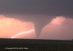
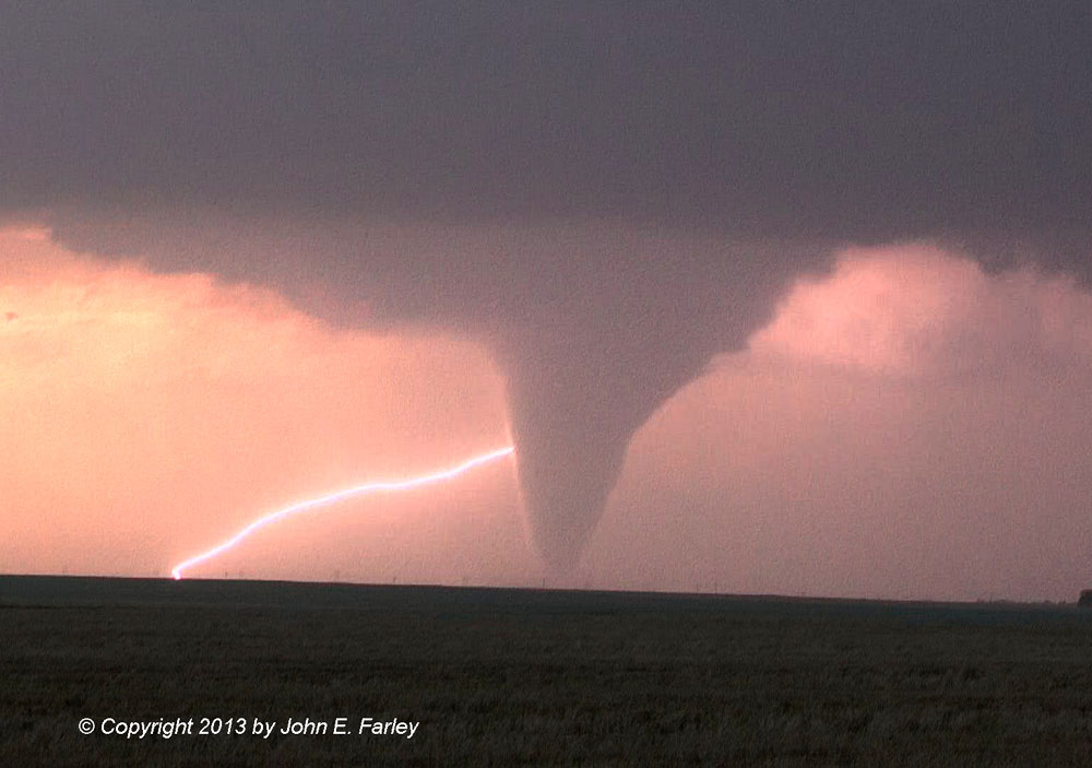
7:25-7:30 Tornado grows; I capture a bolt of CG lightning angling diagonnally to the ground behind the tornado. I consider this one of the best weather images I have ever captured! Here it is:
7:30-7:35 - Tornado becomes very large and takes on appearance of potentially violent tornado. The dust swirl is very large, and at times extends more than halfway up to the cloud base.
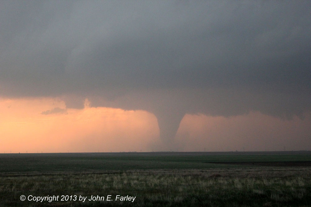
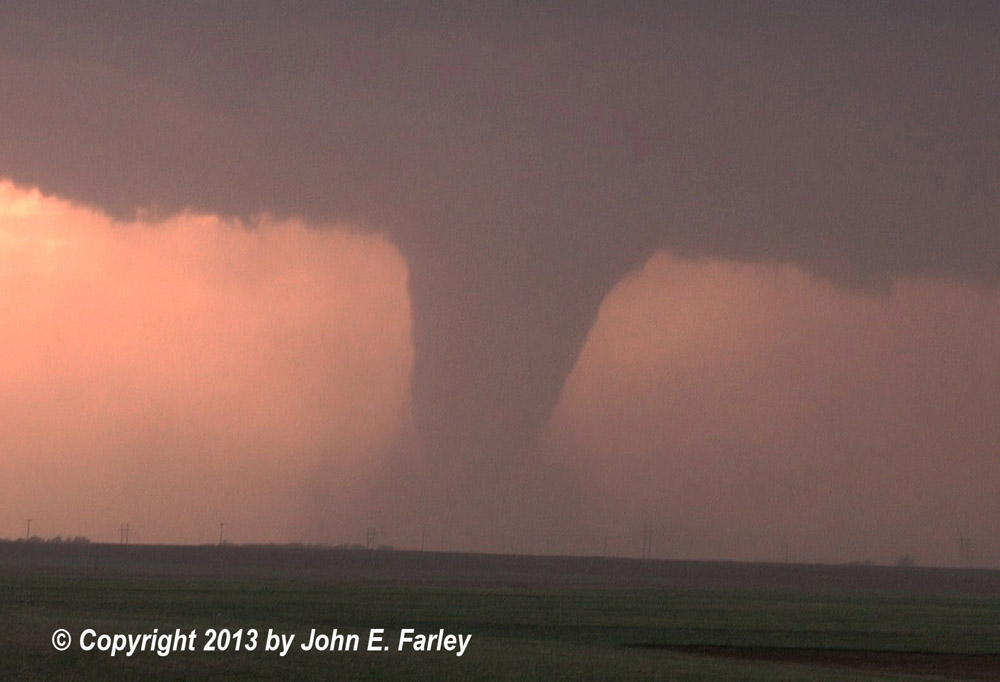
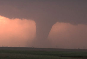
The path width of of this very large tornado would be measured at up to 5/8 mile by the Dodge City NWS's damage survey, and the Doppler on Wheels (DOW) measures 165-185 mph winds. I am not sure of exact time of these measurements, but likely it was around this time. The tornado takes on a variety of shapes, morphing into a wide stovepipe (wide angle image of this phase, also showing storm structure, here) then forming a bulge in the middle, wider than either at the ground or the cloud base.
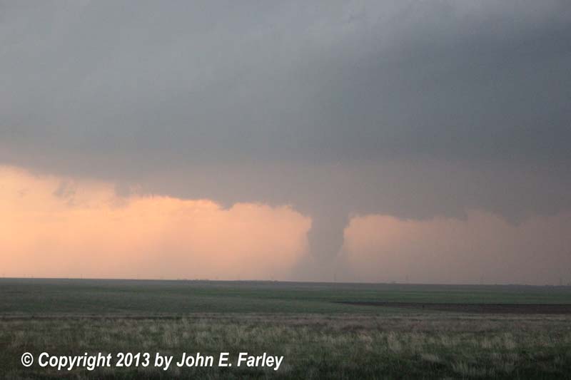
7:40 - Tornado appears to dissipate around this time, as condensation disappears. But the surveyed damage path and visuals of ground circulation by chasers closer to the tornado, even after condensation is gone, confirm that tornado is ongoing. The tornado is around a mile west of Rozel around this time, moving north, and then turns to the NW.
7:45 - A large cone funnel has re-developed. Along with many other chasers, I thought this was another tornado, but in fact it was apparently the same one. Certainly there has been a fair amount of confusion and disagreement among chasers as to whether the tornado shown here is the same one or a second one, but the timing and the damage survey would suggest that this is the same tornado, and that there appeared to be two because the condensation funnel disappeared for a while, even while circulation continued on the ground.
7:47 - The tornado ropes out and dissipates.
At this point, having seen the biggest, strongest, most spectacular tornado of my life, I decided to call it a day and head back to Kinsley to try to find a room at the small motel I had seen there earlier, before the chase hordes took all the rooms. Today was probably the most chasers I have ever seen, with constant lines of traffic, hard to break into, at times, and people stopped everywhere. But I will say that everyone I saw was safe and courteous, with people stopped in safe places, either on side roads or fully off the main road, not pulling into traffic, and checking before crossing the road.
In hindsight, I probably should have stuck around a little longer, as the storm had one more tornado in it, putting down a pretty tornado documented by many chasers about 7 miles or so east of the earlier one. But it doesn't really matter - it just doesn't get much better than seeing a backlit EF-4 tornado in open country, especially when you can get a picture of it with lightning. And fortunately, unlike what happened the next couple days, only one home was damaged by this tornado, with no injuries or deaths, as the tornado remained in open country, missing the only town it came close to, Rozel, by a mile or so.
As I was heading back toward Kinsley, somewhere in the time frame around 8:05-8:20, I saw large dust clouds being kicked up on back side of storm, around and W of Kinsley. At first I thought they might just be low scud clouds, as they were far enough away that i could not see much motion. But as I got closer, and eventually into the wind, it became evident that what I was seeing was large dust clouds being kicked up by high winds on the back side of the storm. From their location, I would presume these winds were associated with a wake low, a phenomenon that can sometimes cause very strong winds behind a thunderstorm, either outside the precipitation area entirely or in an area of only light rain. As I got close to Kinsley, I encountered what I would estimate as 50-60 mph winds.
And even after I got checked into my motel, the storm had one more treat for me - sunlit mammatus and rainbow at sunset. A perfect ending to my best storm chase day ever!
Here is a 7 1/2 minute Youtube video showing highlights from the 22 minutes of video I got of the Rozel tornado and the funnel cloud earlier near Kinsley:
The full 22-minute video will be available on DVD and Blu Ray, without the watermark, later this year as part of my chase season compilation video.
Links:
Reports on this storm from other chasers:
Reports from various chasers from the Storm Track Reports page
Return to 2013 Severe Weather Observation page