
I left Santa Fe around 10:30 a.m., with a target of Santa Rosa, NM. A back-door cold front was stalling over the eastern plains of New Mexico, and would act something like a dryline, with warm, dry air and westerly surface flow to the west of the boundary, and slightly cooler, moist air with northeasterly upslope flow on the east side of the boundary. Dewpoints east of the stalled front would be in the 50s, maybe close to 60 in spots. With very cold air aloft, there would also be decent instability, with CAPE of 1000-1500 j/kg predicted by the models, maybe 2000 or more in spots. While these levels of moisture and instability would not be considered terribly high in the lower elevations of the Midwest, they are more than ample for upslope flow setups on the eastern plains of NM and CO. In addition, strong northwesterly upper flow would provide plenty of deep-layer shear to get supercell storms. While weak low-level shear and, in some places, high condensation levels, would make the setup not particularly favorable for tornadoes, it was a good bet that photogenic supercells would develop on the eastern plains of New Mexico. With setups like this, they nearly always do. Both the 0z models the evening before and the 12z models the morning of this event were in remarkably good agreement on where the most favorable parameters would be - right along the front generally from around Santa Rosa southeastward. And they all blew up isolated storms somewhere in that general area. So I figured the Santa Rosa target was a no-brainer, and indeed Santa Rosa panned out about as well as a storm-chase target ever does!
One thing that did not go exactly as forecast was the time of storm initiation. Most of the models had storms initiating around 2 p.m. or later, but it actually happened much earlier. As I headed down route 285 toward Cline's Corners, I could see that storms had already initiated. There were two that I could see - one that already looked very impressive somewhere well to the southeast, and another one in earlier stages of development to the east. Starting up the computer in Clines Corners, I could see from GRL3 radar that the storm to my southeast was somewhere southeast of Vaughan and southwest of Fort Sumner, which seemed too far away to try to catch up with on a day when the dominant storm motion would be to the SE. So I went for the other storm, which was to the WNW of Santa Rosa, moving generally to the east. As I drove toward the Santa Rosa storm (hereinafter, Storm 1), I could see on radar that the storm down to the southwest of Fort Sumner was splitting, and after a while it became evident that the left split (hereinafter, Storm 2) was dominant, far stronger than the right split. And its movement to the NE, deviant relative to the rest of the storms at this time that were moving southeast, might make it possible for me to later intercept this storm. These two storms that I could see visually were part of what radar revealed to be a long north-south line of isolated thunderstorm cells, probably roughly along the stalled back-door cold front.
Now, here is my account of my observation of each storm:
Storm 1
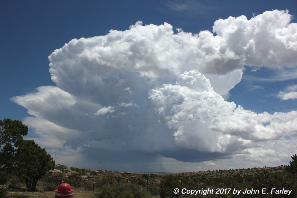
As I got closer, I could see this pretty storm, which was located just WNW of Santa Rosa. Here is a picture of this storm as I approach from the west on I-40:
Another picture of this storm, taken as I got closer to the storm and to Santa Rosa around 12:45 p.m., can be seen here. This storm had now turned slightly right and was moving toward the ESE, closer to the predicted storm motion for the day. Watching the movement of this storm and the lift split to my south/SSW, I figured that if I headed southeast toward Fort Sumner on Route 84, I could observe both this storm and the left split that was moving up from the southwest, so that is what I did.
As I headed down 84 just southeast of Santa Rosa, this small funnel cloud formed around 1:20 p.m. under Storm 1:

It never got much bigger than this and didn't last long, so it reopresented no real threat, but certainly was an interesting thing to see. This, however, was pretty much the last hurrah for this storm, as it weakened and was eventually absorbed in to the much stronger left split storm approaching from the southwest.
Storm 2 - Left split supercell from a storm that formed southwest of Fort Sumner:
This radar image shows that my strategy of heading down 84 to get between Storm 1 and Storm 2 was working pretty well:

Note that the storms are on courses to cross 84 and merge somewhere just NE of the highway; I am between them at this time. Also that both storms have hail markers, Storm 2 has already produced a couple reports of penny-sized hail, and is now SVR warned. Here is a picture as the storm approached route 84:

Since the storm was SVR warned, now had very high radar reflectivity, and therefore likely contained some large hail, I decided to let it cross the road ahead of me. Here is a picture of it just after it did:

The light color of the precipitation shaft is a good indication of the presence of hail, and hail there was! I mentioned earlier that, unlike most left splits, this one became dominant - perhaps becuase the northeasterly surface flow meant that with its northeastward movement, it was getting better inflow than the rest of the storms, including the right-split, that were moving to the SE. In any case, it dropped 2-inch hail as it crossed U.S. 84 around 1:50 p.m., moving NE. This was about 13 miles NW of Fort Sumner, i.e. near the 13 mile marker on 84. A little after this, this storm also absorbed Storm 1, which was moving SE as did most of this day's storms. Here is a picture of the 2-inch hail:

This made me very glad that I waited for it to cross the road ahead of me! In addition to the 2-inch hailstone pictured above, there were also several golfball (1.75") stones on the ground.
Storm 3
This began as a line of storms that formed to the west of my position on U.S. 84, in outflow from the first two storms. It started out as a multicellular line of storms, presumably along an outflow boundary from one of the storms (or where their two outflow boundaries came together), but it gradually consolidated into a more cellular structure and intensified. I had moved north on 84, and I let it cross the highway to my SE, a little farther from Fort Sumner and closer to Santa Rosa than where Storm 2 had crossed. Around the time it crossed the highway, it intensified and by then was SVR-warned. At the time I took the next few pictures, it was still somewhat multicellular, with strong updrafts on both its east side and west side, but it seemed to be consolidating. Perhaps influenced by the movement of Storm 2, it was moving to the ENE, again deviant from the dominant southeastward movements of this day's storms. Here is a picture of the western portion of this storm, as it was crossing 84 to my southeast:

Under the updraft on the eastern side of the storm, this wall-cloud-type feature formed:

Finally, here is a wide-angle shot showing the entire storm:

This view pretty much filled the southeast half of the sky above me, and I needed my 8-16mm lens to capture all of it. Note that you can still see distinct updrafts on the left and right sides of the storm - but it was becoming more cellular and less linear. Around the time this storm crossed 84 to my SE, it also went severe-warned as noted above, and it dropped 1-inch hail west of House, NM around the time these pictures were taken (2:45). However, with this storm moving into a relatively roadless area, I knew I could not keep up with it, and headed back toward Santa Rosa for gas and possibly to intercept something from a new cluster of storms that had gotten a SVR warning or two up near Wagon Mound, but was gradually moving southeast toward Santa Rosa.
Storm 4
After my gas stop, I sat for a while watching the cluster of storms to the northwest approach Santa Rosa. Gradually, the storm at the west end of the cluster began to look better on radar, though it was not impressive visually. But I did eventually notice some faint streaks of precipitation, slightly visible only where well backlit. But the storm was becoming bright red on radar, and the base was starting to look better. It occurred to me that this storm could be developing into an LP ("low precipitation") supercell. These storms have relatively little visibile precipitation, in part because some of it is being carried well downshear from the storm's updraft and in part because they often are producing more hail than rain. But they can produce large hail, and they are usually very photogenic storms. I decided that I should try to get in position to the SW of this storm before it passed over or near Santa Rosa. My plan was to head down route 54 and let the storm pass to my NE, but I missed the poorly-marked exit and found myself heading west on I-40 out of Santa Rosa - right into the 1-inch hail the storm was now dropping. After several rather loud bonks on the car, I managed to get under a roof at a gas station in Colonias, about 6 miles west of Santa Rosa. The hail, in small amounts but of various sizes up to an inch, continued for about 5 minutes, from around 3:55 to 4:00 p.m. Although I messed up what probably would have been the best video of this hail, I did get some. I also got this wide-angle picture of the LP supercell near Santa Rosa just after it passed over the gas station:

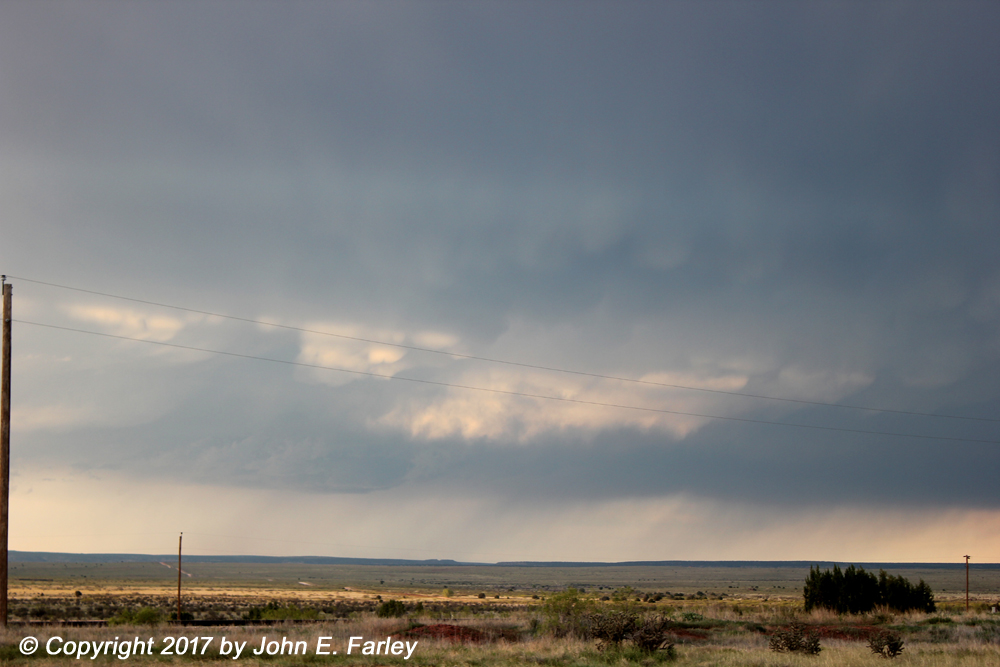
The mammatus in the distance were under the anvil of this LP supercell, well to the southeast. Again, it doesn't look like there is much precipitation under the cloud, but as noted a pretty good barrage of 1-inch hail had just fallen from it where I took this picture, and the storm continued to produce hail, though gradually smaller, as it moved on to the southeast.
Since the hail seemed to be getting smaller per radar, I decided to drive into the storm and see if I could get more hail video. (I was also mistakenly thinking I had not managed to get any video of the 1-inch hail - which thankfully turned out not to be the case; I did get some.) First I tried going down 54 as originally planned, but the storm had pretty much crossed that road and was now heading southeast just to the west of 84 - so I went back to 84 yet again and headed down toward Fort Sumner one more time. Around 10-15 miles SE of Santa Rosa, I caught up to the storm. By now, the hail was smaller, ranging from pea (.25 inch) to dime (.70 inch) size, but there was a little more of it, and much of the time I was in it, the hail was falling in bright sunshine. Indeed with this LP supercell, blue sky was visible in multiple directions from underneath it the entire time, and much of the hail fell in sunshine. This made for interesting video, particularly looking up with the sunlit hail falling from the dark background of the cloud base.
Here is my video of Storm 4 and the hail it produced, from the 1-inch hail west of Santa Rosa to the smaller sunlit hail later southesat of town. The video also includes a distant view of Storm 5, on which more will be said shortly. Here is the video (best if watched full-screen with sound turned up high):
Storm 5
This storm, which developed well to the southwest of me and then tracked southeast, was the only storm of the day to get a tornado warning. It first really got my attention toward the end of the time I was documenting the hail with Storm 4. It was about 40 miles south or SSW of me at that time, but even at that distance and with hail coming down at my location, it was evident that the storm had a very impressive wall cloud:

It also had a strong meso signature on radar at this time (around 4:45 p.m.), as well as a SVR warning. It produced golfball hail northeast of Mesa, NM a half hour or so after this picture was taken. Mesa is along U.S. 285 between Vaughan and Roswell. I took this picture from about 40 miles from the storm - that only seems to work in places like NM and CO. I knew I could not catch up to the storm, but with such good visibility I figured I could at least see it from some distance and perhaps close the gap between me and the storm to around 25 miles if I followed it south. So I went down through Ft. Sumner and poked SW maybe 20 miles past Fort Sumner toward Mesa on NM 20. I did close the gap with the storm somewhat, and new SVR warnings were issued for this storm and another just to its east, both storms included in the same warning. But the storm never looked as good again as when I had taken the picture above, and I decided around 5:30 to let it go so I could get back to Santa Fe at a somewhat reasonable hour. After more SVR warnings, this storm finally did get a TOR warning around 7 p.m. east of Roswell, but so far as I know never produced.
Storm 6
When I got back to Santa Rosa again around 6:30, yet another cluster of storms had formed up around Las Vegas and Watrous and was tracking SE toward I-40 east of Santa Rosa. Again, one of the storms had a SVR warning. I hit a drive-through in Santa Rosa and figured I would wrap up my chase by eating the food while watching this new cluster of storms from the Cuervo exit, about 15 miles east of Santa Rosa. These storms were gradually weakening, though, so when supper was done, I started back. Here are a couple pictures showing the westernmost storm in the cluster and some sunlit mammatus that formed under its anvil as the sun lowered. Soon, I was passing through Santa Rosa for the fifth time this day - another indication that my target of Santa Rosa had worked out pretty well!
Although I did not see any tornadoes this day (and did not really expect to), I would probably rate this as my best chase so far in 2017. One photogenic supercell after another, the biggest hail I have seen in a number of years (fortunately I was smart enough to avoid driving into the 2-inch hail as it was falling), a decent funnel cloud picture, and - perhaps best of all - all these gorgeous scenes more or less to myself, with none of the crowds and chaser jams you get in KS, OK, or other areas more traditionally in chaser alley. Gotta love storm chasing/photography in New Mexico!
Return to 2017 Severe Weather Observation Page
Total chase distance: 492.5 miles