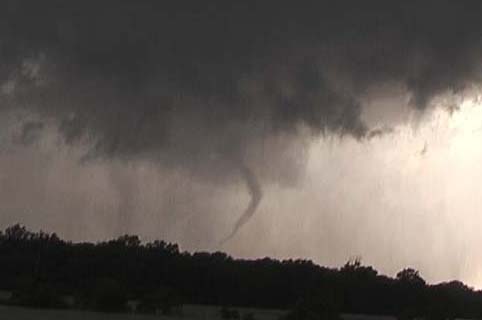
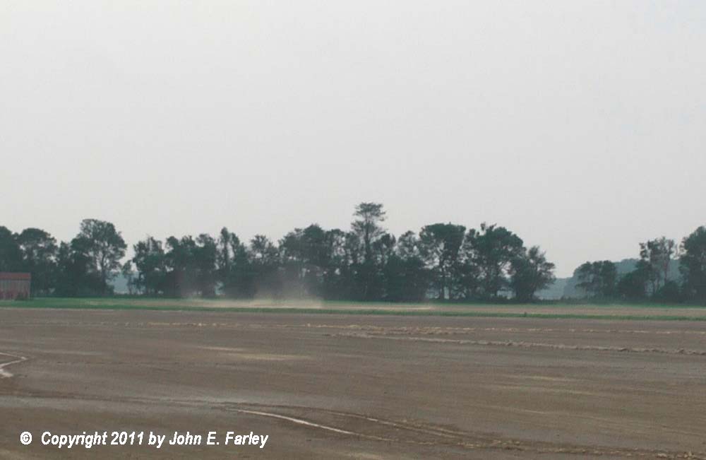
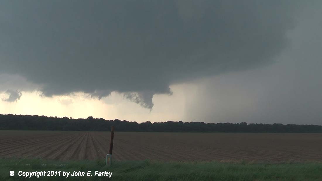
Long: SPC issued a high risk for the second day in a row, generally from around St. Louis to Memphis including nearby parts of MO, AR, IL, KY, and TN. This was part of a much larger area at risk of severe weather as very strong dymamics associated with an intense system would affect a large area from the central and northern plains eastward to the Great Lakes and south to the Gulf of Mexico. Much like the previous day, it appeared that conditions favored numerous, fast-moving storms. Like the previous day, the best instability would be to the south and the best shear to the north. Since I ended the previous day in Tahlequah, OK, I decided to target Arkansas, since it was the most accessible area of interest from that location. The only real question was how far east and how far north or south to go. I decided not to go too far east, since with the storms again likely to become numerous, it would be best to avoid being too far away at initiation. Also, the RUC and the SPC mesoscale analysis both showed that the best combination of instability and shear was setting up along or just east of the U.S. 67 corridor, from around Little Rock to the Missouri bootheel. This is also roughly the northwestern extent of the good, flat, fairly open chase terrain, with hilly, wooded terrain to the west and north of that area. So I decided to set up around Beebe, where I could easily adjust north or south, with also good east options not too far north or south of there. Storms initiated around 2 p.m. in a line from near the northeast corner of the state southwestward to north, west, and eventually southwest of Little Rock. I started west to intercept one, but decided to backtrack because it weakened, the next one south looked better, and after yesterday, I wanted to be SURE to have a good east option - the storms would be moving fast, just like yesterday. With no direct east option from Beebe, I needed to either go south to I-40 or northeast on the U.S. 67 freeway to U.S. 64. Based on storm motion, I opted for the latter, figuring I could intercept the storm around Augusta. I was well ahead of the storm, probably a little more than I wanted, but in good position. While I was waiting, the gradient winds were very strong, at times blowing up dust swirls and plumes in the nearby fields. They looked a little like gustnadoes at times, but they weren't, as they were associated with gradient wind, not outflow. The storm quickly became supercellular, and got a SVR warning then a TOR warning. I intercepted it a few miles south of Augusta on route 33, from some distance as it passed between Augusta and Searcy. It had a decent wall cloud, but as it got closer it weakened and another storm that had formed just to its south rapidly intensified. I moved a little farther south on route 33, to around 6 or 7 miles south of August to intercept the trailing cell, which would eventually give me my first tornado of the day, a brief one around 4:50 about 5 miles SSE of Augusta. Prior to that, the storm developed a nice wall cloud with a lowering that was mostly rising but may have had a little rotation - but not much. After a while a new area of rotation formed much closer to me, started to spin, and crossed the road just north of me. Once it had passed, I headed back north to keep up, and soon noticed a large dust swirl just beyond a clump of trees a quarter to half mile to my northeast. Tornado! I quickly stopped and got out the video camera, and got a minute or so of video of the tornado. Looking up above the dust swirl, I saw a small nub funnel directly above the dust swirl. Here is a picture:

The dust swirl doesn't show up well in this picture, but it was there, directly underneath the nub funnel. In fact, as noted above, I saw the dust swirl first, then, looking up above the dust swirl, I saw the funnel. This tornado lasted about 2 minutes. Video of the tornado and of the features that preceeded it can be seen here:
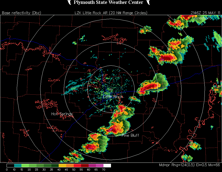
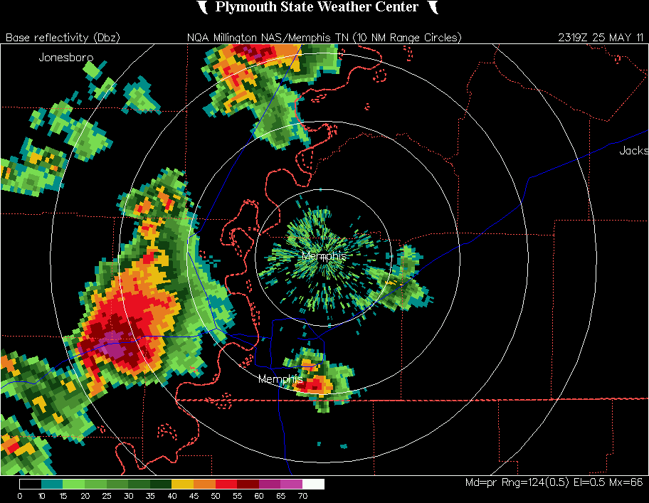
A radar image showing the storm at the time the tornado occurred can be found here. In the string of supercells extending along a NE-SW line at that time, the one associated with this tornado is the one between the second and third rings northeast of the radar site. Note that this cell had a pronounced hook echo, as did a couple of the others.
I couldn't keep up with this storm so I blasted east on 64 then south from Parkin to intercept the next storm down the line, finally catching up just northwest of Greasy Corner or about 6 miles north of Hughes. I hit some fairly heavy rain but no hail by the time I reached I-40 at Shell Lake, where I jumped east one exit to get farther south, as the meso was tracking south of I-40. I stopped a mile or so northwest of Greasy Corner on routes 149 and 50. The storm, which had nice backlighting from that location, was cycling at the time and had two mesos - an older, quite rain-wrapped one to my southwest, and a new one just to my northwest.
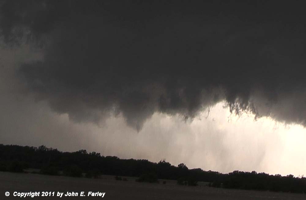
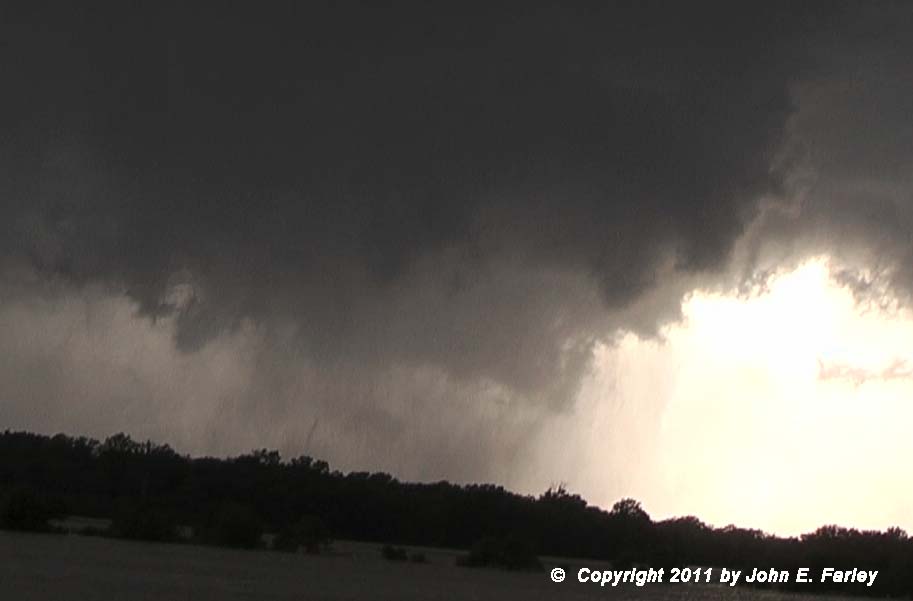
The second tornado of my day, which I saw at that location, began as a nicely backlit rope or thin elephant trunk tornado, one of a series of ropes and funnels under a strongly rotating wall cloud associated with the newer meso, with thin curtains of rain wrapping around the tornado. The initial condensation funnel to the ground lasted only about 30 seconds, but was followed by continuing strong rotation with intermittent funnels, some of which were rotating around the wall cloud. The strong rotation with at least occasional touchdowns lasted about 5 minutes but not sure if the tornado was down that whole time or intermittently on the ground, as new vortices kept forming. It was definitely on the ground for the initial period of 30 seconds or so, with the condensation actually rising from the ground to meet the funnel cloud above. But it was on the ground at other times during the five minutes, too, as the video shows dust swirls on the ground under a couple of the other funnels that formed later under the wall cloud. It is hard to tell exactly how much was dust being pulled up and how much was the rotating rain curtains, especially with some trees on the other side of the body of water I was looking across at the tornado. But there are definitely a couple times in the video where, if you look closely, you can see dust surging up from the ground under later funnels after the initial condensation to the ground disappears. Here are a few pictures:

Condensation from ground rising to meet funnel above. A picture as this condensation from the ground first appeared can be seen here.

Thin elephant trunk appearance 15 or 20 seconds later.
Later funnel with dust swirl rising underneath.
Here is video of this tornado (best viewed full-screen):
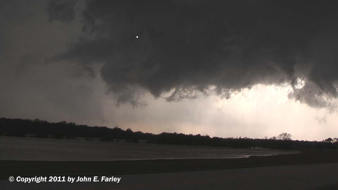
I think it is rather likely that this was not the only tornado that occurred here, though. The tornado pictured above occurred under a new wall cloud as the storm cycled. To the southwest, however, was another, more rain-wrapped meso, which had a large wall cloud with pendant funnels. Here is a video capture showing this feature; the wall cloud that produced the tornado pictured above (which was still strongly rotating at this time) is in the upper right of the picture, and the older, rain-wrapped meso is in the left background of the picture:
As this latter feature got closer (and on a slightly more southerly track), I bailed south, but as I did I noticed a big cloud of dust just to my west. That will get your pedal to the metal, and it did! Encountered the edge of the wind field briefly, but avoided the strongest wind and the area with the dust. Once I had blasted south enough to get out of the way, I turned back toward the meso and saw this:
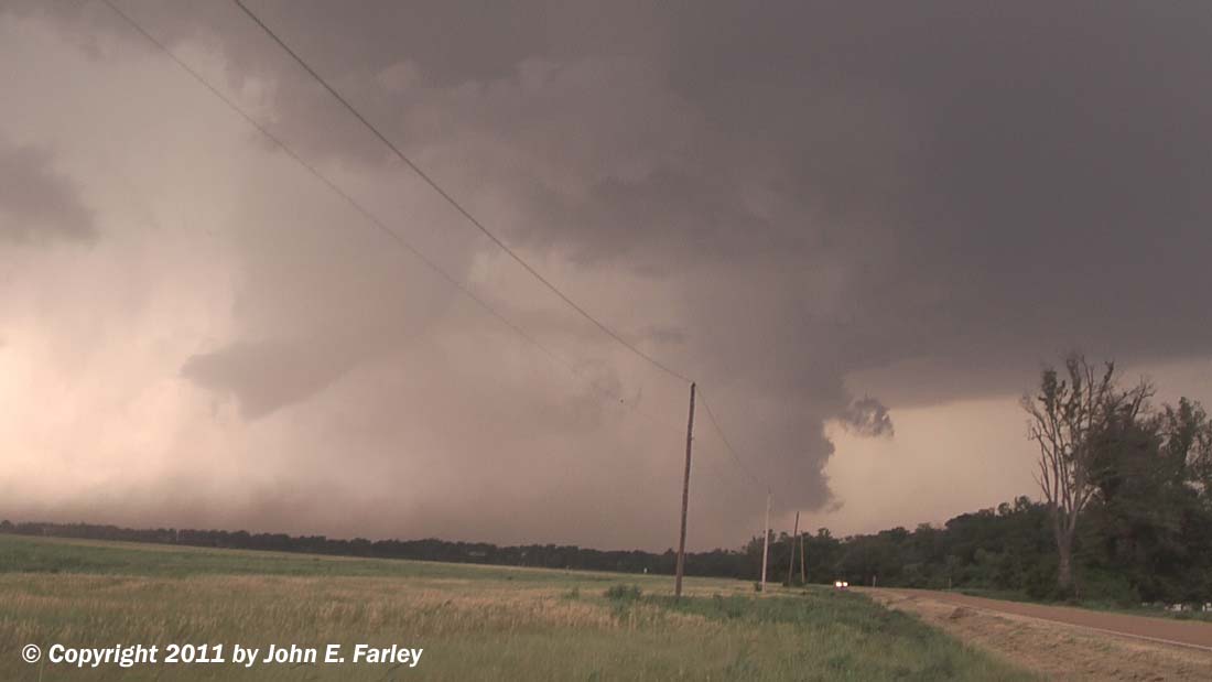
I think that at least some of the dust was either from an inflow jet (perhaps to the tornado pictured above) or RFD, but with that much dust that close to a large funnel more than halfway to the ground, I think it is also fairly likely that there was some degree of circulation on the ground, so I am calling this a likely tornado also. It may actually have been on the ground longer than the one above, as my view of this one early on was not as good due to the wrapping rain. However, it dissipated fairly quickly, within a couple of minutes, from when I first was in position to see it, which was a minute or two after I blasted south to get out of its way, so it could have lasted as long as 3 or 4 minutes. Here is a short video clip of it:
Here are some radar images:
Reflectivity image from the time of the first tornado - Note the very pronounced hook echo, as well as the very high reflectivities just northeast of it, where the storm was producing hail just south of I-40.
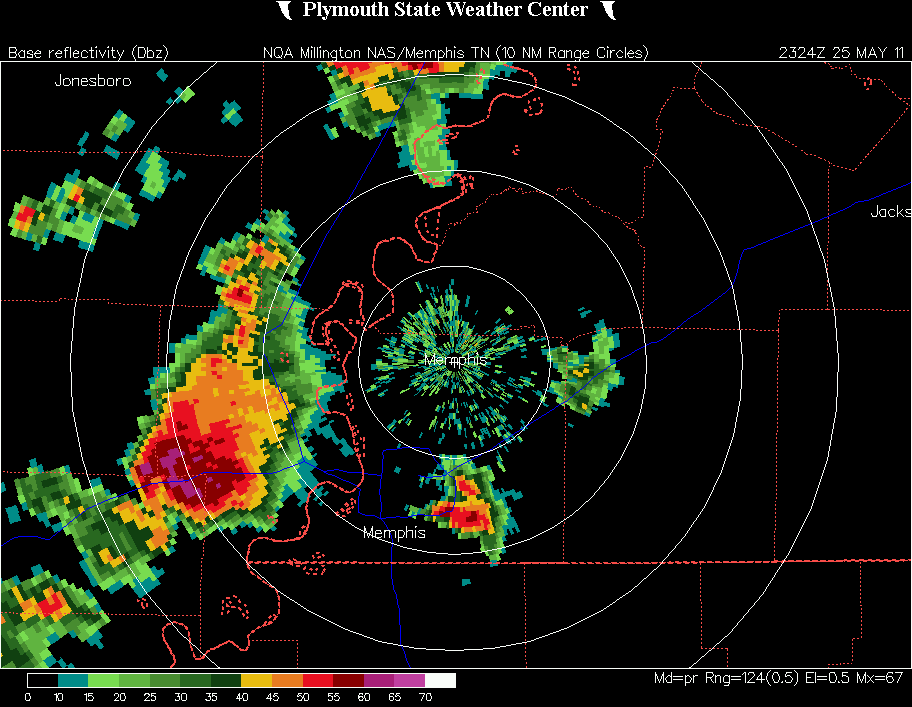
Reflectivity image from the time of the likely second tornado, about 5 minutes later - Still a very pronounced hook echo, though there is a little weakening in the middle of the hook appendage, perhaps owing to the presence of two circulations at the time.
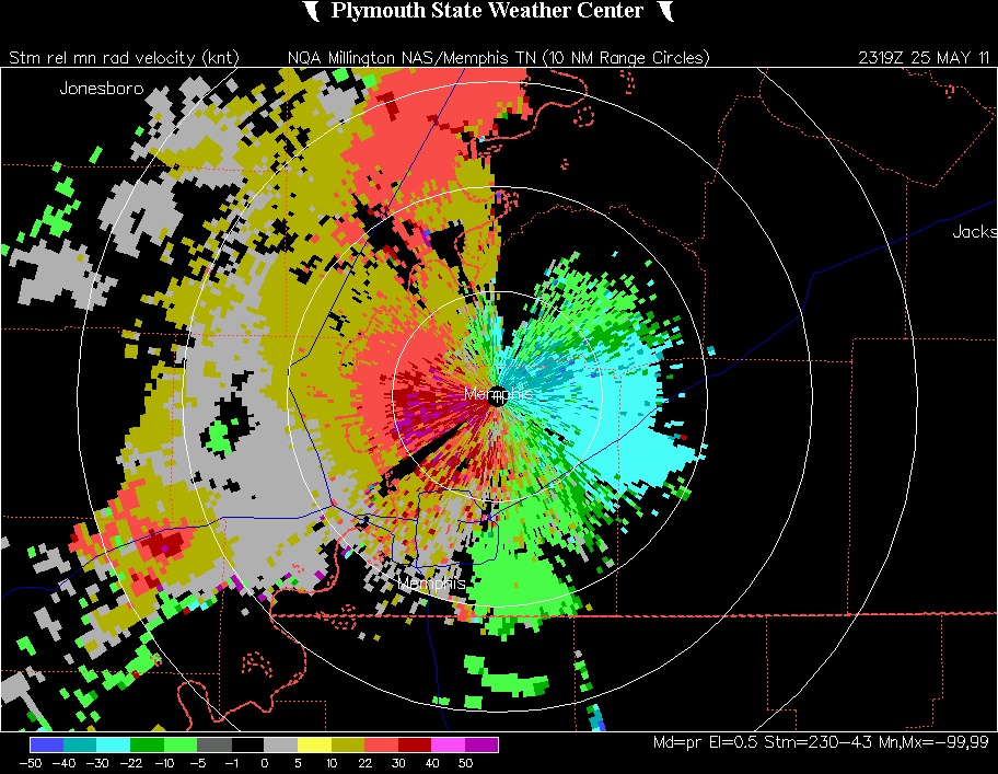
Storm-relative velocity image from the time of the first tornado - Note the adjacent red and green areas where the tornado occurred, as well as the very strong winds in the precipitation core.
Finally, after I was through chasing and just heading east on I-40 to pick up I-55 to head back toward St. Louis, I saw what I first thought was steam from a smokestack somewhere in the Memphis or West Memphis area. Then I saw a power flash under it, and realized that it was in fact attached to the storm. Absent the power flash and the damage reports from West Memphis, I would never have thought this was a tornado, but after seeing the power flash and later hearing reports of damage in West Memphis, I thought it might have been. There has been a lot of discussion and debate about the nature of lowerings that were seen with this storm in the Memphis area. A picture in the Memphis Commercial News Website appears to show a beavertail, not a funnel or wall cloud - and that is also what the NWS in Memphis says that this feature was. However, a picture that appeared on the Weather Channel showed both the beavertail or inflow tail feature in the newspaper picture linked above and another lowering to its southwest. Numerous people, including some chasers, in the Memphis area observed rotation, so what probably led to some of the confusion is that some people were looking at the inflow tail feature shown in the newspaper picture linked above, while others were looking at the rotating lowering behind it, which some have described as a funnel cloud and some as a rotating wall cloud. As I discuss below, it turns out there was a tornado or at some stages I suppose you could call it a waterspout as it was over water for part of its life. In any case, I was too far away to tell exactly what it was at the time, and probably would not have been suspicious if I had not seen a power flash under the feature.
Here is a video capture looking east into West Memphis from I-40 from just after the power flash:

Edit - 6/3/11 - A damage survey by the NWS in West Memphis initially found that the damage in West Memphis was due to straight line winds. However, multiple videos have appeared on the Web showing a funnel cloud with clear rotation, and both a debris swirl on land (accompanied by power flashes and a damaged power pole) and a swirl of spray on a small body of water near the Mississippi River. Links to four videos can be found here. Additionally, a highly experienced and respected storm chasing tour group observed this event and indicated it was a tornado. Taking all this into consideration, there is no doubt in my mind that a weak tornado/waterspout occurred in West Memphis. The only question was whether it was strong enough to meet the criteria to be considered a tornado. But since one of the videos shows power flashes in the same place as the debris swirl and a power pole that was blown over (at 2:15 in Brandon Ivey's video, the second one listed on the video links page), I would think it likely that the criteria was met and that in fact an EF0 tornado occurred.
Additional edit - 6/4/11 - Perhaps based on the same videos I discuss above, the NWS has now revised its assessment and confirmed a tornado in West Memphis. The tornado was rated EF1, with estimated 90 mph wind, and was on the ground for 2.53 miles with a path width of 100 yards, and began at 6:48 p.m. Also they confirmed the initial tornado near Greasy Corner, which was rated EF0 with estimated wind of 80 mph and a damage path of 1.05 miles, beginning at 6:18 p.m.
With regard to the West Memphis tornado - Since the power flash I saw was pretty much directly under the lowering, I would would be pretty sure that what I saw was the tornado. In addition to the tornado, it is entirely possible that there was also straight-line wind damage, as the damage survey indicated, with some of the damage perhaps the result of either RFD wind or of an inflow jet blowing into the circulation - similar to what was causing at least some of the blowing dust I had to get out of the way of earlier. Perhaps some of that was the basis of the initial damage survey. One thing I am quite sure about is that the feature I saw over West Memphis was the lowering associated with the tornado, not the inflow tail or beavertail that also occurred with this storm. That is because I was looking at the storm from the west, so would have seen the trailing feature (wall cloud/funnel/tornado), not the leading one (inflow tail). Also, the feature I saw was right where the hook was on the radar.
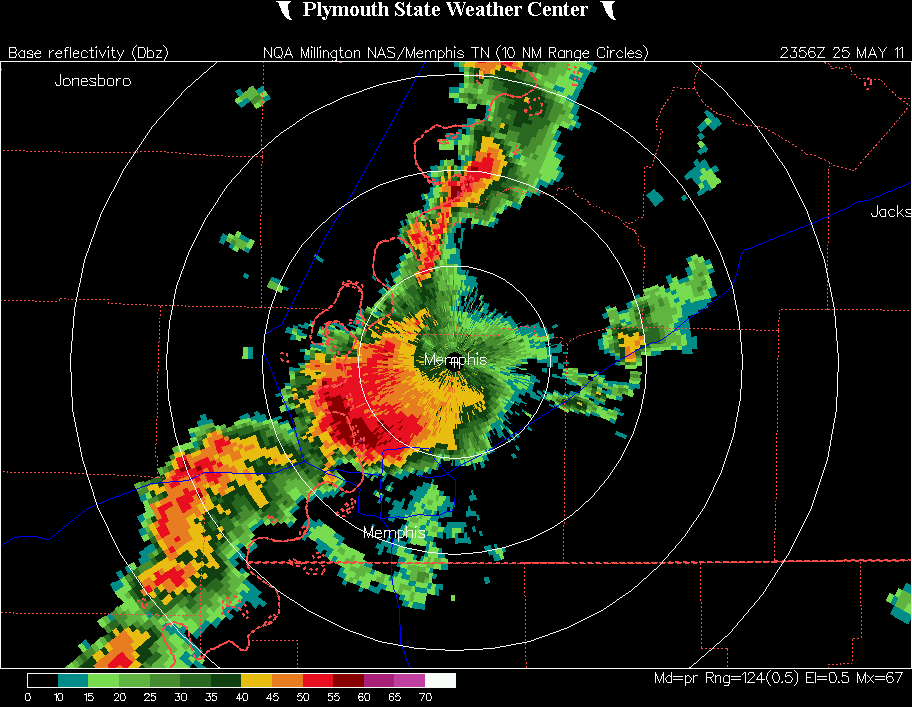
Reflectivity image from around the time I saw the lowering over West Memphis - Note that the storm still has a hook echo, and it is right over West Memphis, very near I-40/55 - but comparing this reflectivity image to the earlier ones at the time of the tornadoes, it is evident that the storm is not as strong now as when it produced the earlier tornado or tornadoes near Greasy Corner.
This was the first time I had ever chased in Arkansas. I had heard from other chasers that eastern Arkansas is good chase country, and I would agree with that. There are some wooded areas, but it is very flat and there are lots of open areas. I would say that overall it is just as good as Illinois or western Oklahoma, and better than anywhere in between. And the storms today actually stayed much more discrete than yesterday in Oklahoma, making for a much more enjoyable chase. Still very fast-moving, 45-55 mph and sometimes more, so you had to plan an intercept carefully and could not keep up for long, but still better than the "storms everywhere" situation in Oklahoma the previous day. Arkansas definitely made a good first impression!
Total chase distance: 475 miles.
Return to 2011 Severe Weather Observation page