
A back-door cold front had moved into NM from the northeast a couple days earlier, stalling west of the central mountains. Today, warm air would try to push the front back eastward toward the plains. Overnight, the front had been reinforced from the east by outflow from storms that had developed in the upslope flow east of the front the previous day. Today, the front (which in some regards also resembled a dryline, with very moist unstable air to its east and very dry air to its west) would again be the focus for thunderstorm development. Moisture and instability, however, would be better east of the front today, with CAPE projected to be in the 2000-3000+ j/kg range on the eastern plains and dewpoints in the upper 50s and 60s - more than enough to get the job done at high altitude. In addition, with southeasterly upslope flow at ground level and northwesterly flow aloft, directional shear would be excellent, although the flow would not be overly strong. Still, with this combination of instability, moisture, and shear, models were predicting the energy-helicity index (EHI) to be as high as 6 in places on New Mexico's eastern plains. That is unusually high for this area; indeed 3 is enough for tornadoes in many setups. In successive outlooks, SPC went from marginal risk to slight risk to enhanced risk for parts of the eastern plains in NM. Generally the enhanced risk area extended east and south from Santa Fe and Las Vegas, NM, but the models were suggesting the best combination of instability and shear might be from about Las Vegas northward along and just below the east slopes of the Sangre de Cristo Mountains. Perhaps a little more instability southward, but more shear northward. This suggested the best chance of tornadoes might be around Las Vegas or northward from there. Storms were forecast by the models to initiate first over the Jemez Mountains and the southwestern mountains, but with stronger and more sustained storms initiating a little later, around 3 p.m., over or near the Sangre de Cristos. Based on all this, I set Las Vegas, NM as my initial target, and aimed to get there around 2:00 p.m.
The Chase:
As planned, I was into the Las Vegas, NM target area around 2:00 p.m. - and right as I was coming into Las Vegas from the south on I-25, I noticed an anvil and some updraft towers that appeared to be a little north or northwest of town. Right on time! I exited at the exit on the north edge of town, watched the developing storm from there for a few minutes, and then worked north on the roads that parallel I-25 between there and the Las Vegas airport exit.
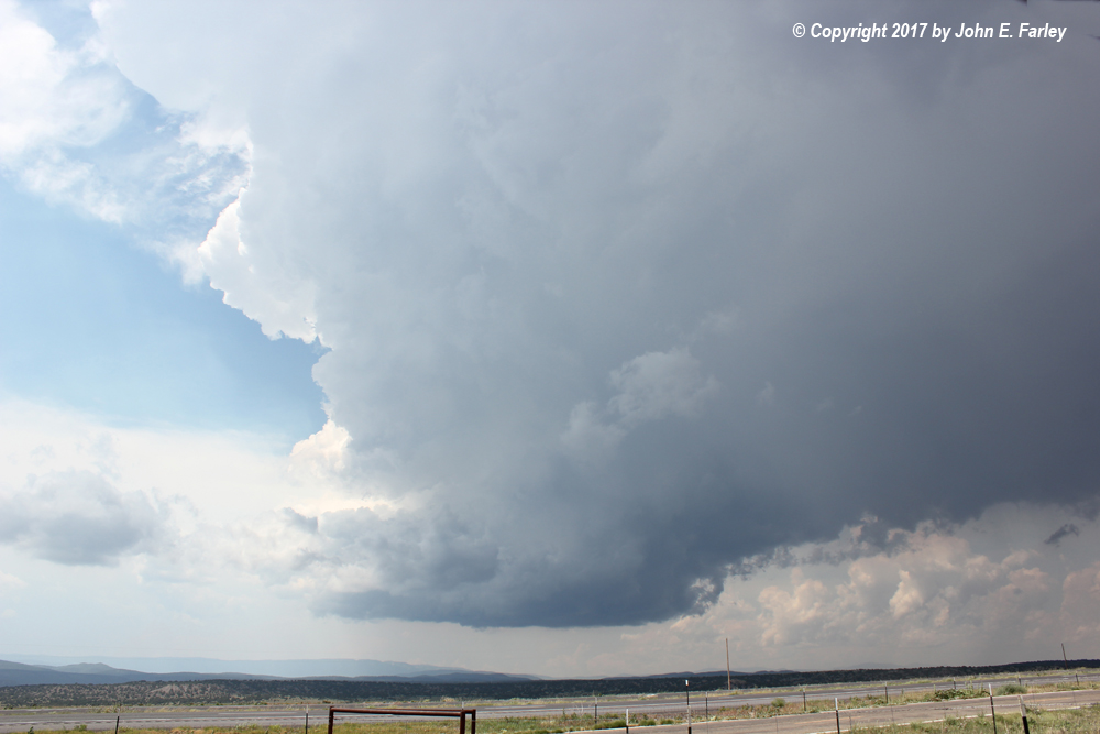
Found a spot along the frontage road a couple miles S of the airport exit, and sat and watched for about an hour as the storm became a photogenic, LP-ish supercell. Here is a wide-angle photo of the storm during this phase:
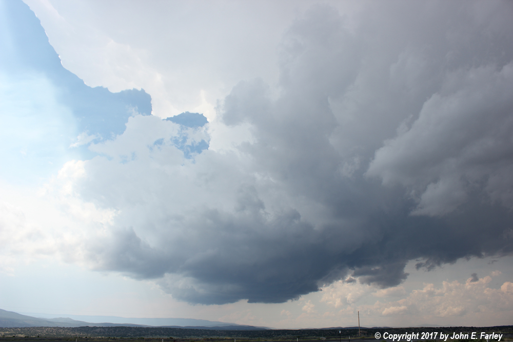
A more zoomed picture of the storm around the same time can be seen here. The storm was moving very slowly, pretty much right toward me or toward a point just to my north. So I did not have to move; could just sit and watch it. As shown in this picture, the updraft remained strong and the anvil became backsheared, knuckled, and quite hard along the edges. At 3:17 p.m., the first SVR warning was issued, for ping-pong ball size hail and 60 mph winds. Literally one minute later, at 3:18 p.m., the storm dropped golfball hail at Sapello, the reported location of the storm in the warning. This was several miles northwest of my location. This picture shows the storm about the time the warning was issued and the golfball hail occurred. I stayed in my location until about 3:30, when the storm was getting closer, then retreated south and a little east, to where the road after an eastward jog turns south at the railroad tracks. The storm maintained its supercellular character up to and including this time, but became more classic and less LP, with increasingly visible rain and hail shafts. Around 3:50, a good-sized dust plume formed to my NW from the storm's outflow wind, which blew the dust from the NE to the SW. I was still in the southeasterly inflow, which had been growing increasingly strong and now was strong enough to shake the car. A little after this I moved south again, to near the exit where I had originally gotten off I-25. I started to get a little rain and small/soft hail after a few minutes there, and the storm was now starting to merge with another to its west with the storms in the Las Vegas area taking on more of a linear character. No longer SVR-warned. On radar and visually, I noticed stronger, more supercellular storms to the north in the Wagon Mound area, and since my storm, still mostly to my north, was no longer SVR-warned, I decided it would be safe to blast through it to get to the more interesting storms to the north. As I did, I encountered dime sized hail, with possibly a few quarters - could not really tell the exact size. But there wasn't a lot, and by a few miles past the airport exit, I was out of it. As the storm to its west merged in to the Las Vegas storm, it reintensified, got a new SVR warning, and dropped golfball hail in Las Vegas at 4:26 p.m., but it was now behind me, still going linear, and I had my eye on the storms near Wagon Mound.
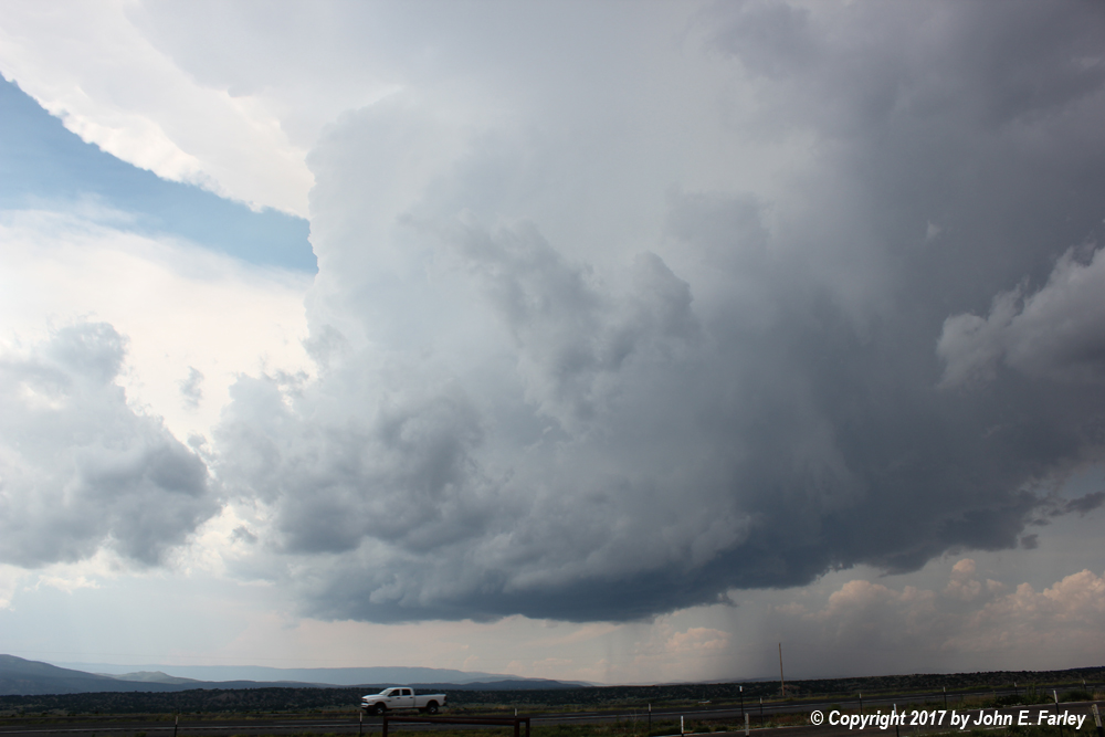
There were initially two storms in that area, one just NW of Wagon Mound and another farther north near Springer, both SVR warned. And the one near Springer also had a TOR warning for a while. But as I got closer, I could see both visually and on radar that a new storm was forming and intensifying just NW of the Wagon Mound storm. With these storms moving SE or SSE, this would be the new tail-end storm, and it was the one that got my interest. Here is a picture of the storm at this time, taken through my car window on I-25:

I was concerned I might get caught in the core of the lead storm around Wagon Mound, but it became evident that the storm was still just north of there and I could get past it. So I headed up NM route 120 from Wagon Mound to the NW, toward the intensifying tail-end storm which was near Ocate, located on route 120 22 miles NW of Wagon Mound. A few miles out of Wagon Mound I lost data, so when I stopped to view the storm around 10 or 12 miles NW of Wagon Mound (i.e. halfway to Ocate or a little more) I did not know that the storm got a tornado warning at 5:00 p.m. based on radar indication of a possible tornado near Ocate. But I could see that it was strengthening, as it formed an elongated wall cloud with an inflow tail on its NE side, and an intensifying precipitation core behind and extending to the NE of the wall cloud:

This picture was taken around 5:05 p.m. In the next few minutes, CG bolts began to zap down nearby, so much so that I rolled up the car windows and took video through a window. A little after 5:10, I heard a loud bonk of a hailstone on the car, and knew it was time to bail southeast, before I got swallowed up by the approaching hail core. As I got back into data range, my phone alarmed frantically for the tornado warning. Looking in the side view mirror, I could see that a large lowering had formed and looked to extend all the way to the ground (although because of the hilly terrain, that was very hard to be really sure about). The road there has no shoulder, and even field entrances only exist every 3 or 4 miles. Long story short, after driving a couple miles with a possible tornado in my rear view mirror and no place to pull off the road, I just stopped and jumped out into the hail to get at least a little video, as I could see no traffic coming either direction. Here is a capture from that video, taken around 5:15 p.m.:

I don't know whether this was a tornado or not. At this point, there was some higher ground between me and the lowering, so I could not see all the way to where it intersected the ground. So I don't know, but it certainly could have been. Since after a short time of getting video I could see that a couple cars were coming, I had to move on. After a couple miles more I found a place to stop and get more video. Here I had better views of the ground, and it looked like the lowering there did reach the ground, but it was hard to ascertain rotation. At this point, the video probably tells the story better, so let's turn our attention to that.
The video linked below, taken at various points along NM route 120 northwest of Wagon Mound during the first of the three tornado warnings issued for this storm, is divided into four segments. The first segment, taken from around halfway or a little more from Wagon Mound to Ocate, was taken around 5:10, shortly after the tornado warning was issued. It shows the updraft base (with no notable lowerings at this time) and the rapidly-intensifying precipitation core to its north and northeast. The second segment was taken from a few miles southeast and a little under 5 minutes later, around 5:15. It shows what may or may not have been a tornado. I apologize for the shakiness of this part of the video - I had no pullovers and literally saw what may have been a tornado in my rear view mirror. So with no traffic visible behind me then, I just stopped and jumped out into the hail to at least get some video. Couldn't get a long segment because, by the time I got the camera rolling, traffic was approaching. I think this segment is one of the more likely places in this video where there may have been a tornado, but I cannot tell either way with any certainty. The third segment of the video was another five minutes later, and again a mile or two southeast toward Wagon Mound, still looking in a general northwesterly direction. The lowering looks to reach the ground in this segment, but it is hard to ascertain rotation. Not sure if this is the same lowering as in the second segment, but it is in the same general part of the storm. In the final fourth segment (from the same spot), the lowering from the previous segment breaks apart without much rotaton evident, as another denser lowering comes in behind it, partially hidden by rain. This lowering may have or not have had a rain-wrapped tornado associated with it.
Overall, I am quite uncertain as to whether or not any of the features shown in the preceding video was a tornado. If so, I think most likely in the second or fourth segments. But due to distance, terrain at times blocking part of the view, and difficult conditions for getting video, it is hard to say. The road network is extremely limited - route 120 is the only game in town here, with no side roads and no shoulder with very few places to pull over - and the storm and its hail core were bearing down on me. Still a very impressive storm at this point, whether tornadic or not.
By now, the main precipitation core was coming closer and the view of the potentially tornadic storm was becoming more difficult, and I knew I would be overtaken by hail and heavy rain if I stayed where I was. So I decided to return to Wagon Mound and head back toward Las Vegas on I-25. In that area southbound I-25 actually goes toward the southwest, so I figured that would bring me back closer to the track of the storm. Only problem is that, aside from one rest area (which turned out to have a rather obstructed view due to hills and mountains), there is no exit for more than 20 miles. It turned out my only recourse was to stop along the freeway, something I normally do not do while chasing, but I was not going to miss a potential tornado view due to a lack of exits. I pulled way over as far as I could in a spot with a somewhat unobstructed view. By this time, the storm had its second tornado warning, issued at 5:33 p.m., a few minutes after the initial warning had expired. This warning indicated the position of the possible tornado as 10 miles west of Wagon Mound, and also mentioned potential for 2-inch hail. Where I stopped, around 5:45, I could see a number of ragged, scuddy lowerings that extended at least close to the ground, then a more organized-looking lowering emerging from behind a mountain, as I looked northwest. Here is a picture of that lowering:

Around the time of this capture, I was really pretty sure this was a tornado, but I am less sure now. In fact, I now think more likely it was not, although I once again am not sure. As before, the portion near the ground is obscured. But although there did appear to be a little rotation at times, a couple minutes after the above capture the lowering began to break apart, and as this happened it appeared that all or nearly all of the cloud tags were moving pretty much in the same direction, north to south (right to left) along with the storm. In any case, you can look at the video and see what you think. Do keep in mind that, standing along the freeway and not wanting to be there longer than necessary, there was not time for niceties like tripodding, so the video is again a little shaky. But you can get the idea. Here is the video:
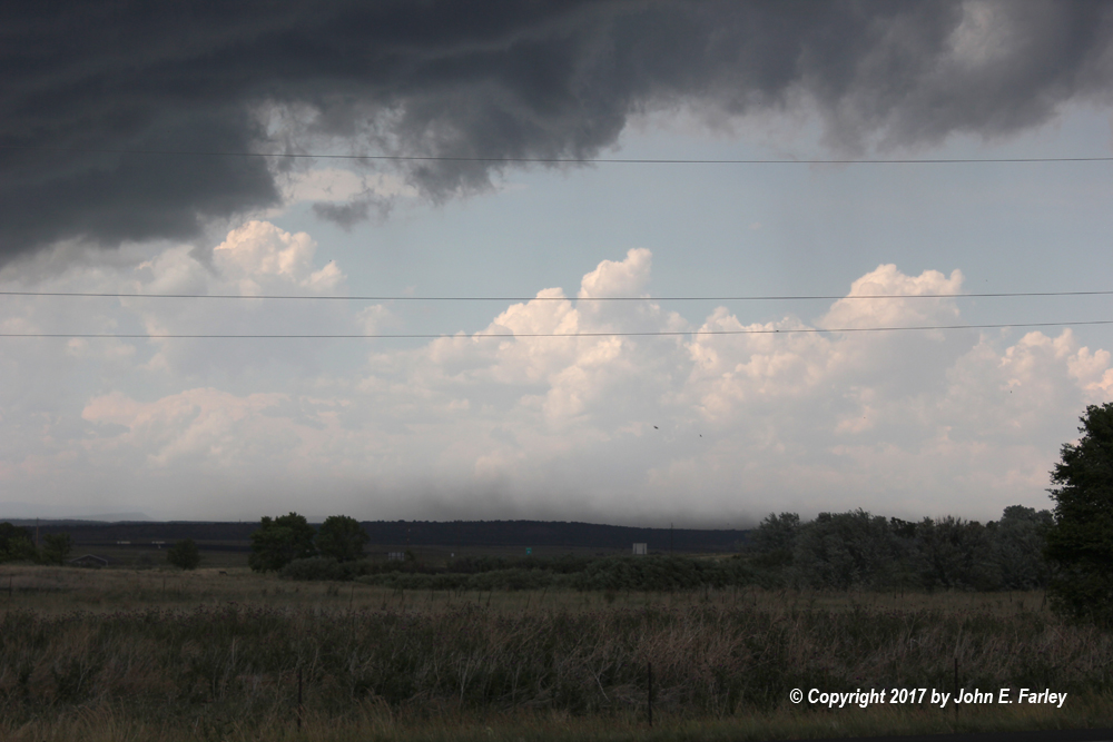
After this I decided to continue on to the next exit, which is the exit for Fort Union National Monument. At that exit there is a frontage road that runs along the freeway, so I headed back north to a high spot where a handful of other chasers also stopped. I watched from there as the storm drifted slowly toward me, taking on an increasingly HP character. As the storm got closer I could see a large, wide, low-contrast wall cloud. When the second tornado warning was about expire, a third one was issued, which also mentioned the possibility of 3-inch hail. And later after that, a SVR warning was issued which also mentioned potential for 3-inch hail. During this HP phase, radar reflectivity in parts of the storm was in excess of 70 dbz, with a 3-inch hail marker. Here is a picture of the storm during this phase:

I watched the storm from this point for quite a while, as it slowly moved closer. As indicated in the third tornado warning, the storm was by this time moving south (toward me) at only about 10 mph, so I had plenty of time to watch it from this vantage point. During this time I did note some rotation in a couple small lowerings to my NW, or to the southwest of the main, broad wall cloud pictured above. However, it was becoming more evident that the main threat from this storm was becoming hail and flooding rain more so than tornadoes. I remained at this location until around around 6:30 or a little later. Long enough to get in outflow rather than inflow, which I had been in for most of the day. With the storm getting close, I decided to drop south to Las Vegas, get a quick bite to eat, and consider my next step.
Once I had done that, with the time around 7 p.m., I could see that the storms were becoming more linear, though the storm I had been chasing was likely still supercellular but rapidly becoming embedded in a line of storms. It would pass perhaps 20 or 25 miles east of Las Vegas. Since there was a road heading east, I decided to go east for one last view of the storm. About 10 miles east of Las Vegas, I noticed a couple chase tour busses from Texas with their clients out photographing and videoing the storms to the north. In another five miles, I found a nice viewing spot and got a few more pictures of the storm including one shot with CG lightning with the lightning trigger. The vast majority of the considerable amount of lightning, however, was cloud to cloud, not CG. Here is a picture of the storm, now embedded within a line of storms, taken from this location:

Once again, New Mexico did not dissapoint! Two photogenic supercells, slow moving and easy (except for the very limited road network) to chase. Maybe a couple tornadoes, but even if they weren't, interesting storm features nonetheless. And as usual in New Mexico, not crowded, though I did see chasers in various places, especially once I was on the second storm. Had a nice chat with an Albuquerque chaser at one point who knew of me through Facebook or the Web; unfortunately can't remember her name now.
I am guessing I will never know whether or not I saw a tornado (or maybe even two?) this day. There were no reports of tornadoes or even large hail with this storm in the LSRs, although there was a picture of 2-inch plus hail from Mora County along with reports of broken windows on the NWS Albuquerque Facebook page; these did not make the LSRs probably because they had no specific time or location. But the lack of reports is not entirely surprising given the very thin population of this area - really not even any roads in the area of the storm besides NM 120 and I-25. The biggest hail I encountered with the second storm was only around dime size, but I made an effort to stay out of the hail and I am sure not only from the aforementioned hail photo but also from the radar imagery of the storm that there was much larger hail. Wouldn't surprise me at all if some 3-inch or bigger hail fell somewhere in unpopulated range land - again I guess we will never know for sure. Regarding the possible tornadoes, though I will probably never know, I am more bullish on what I saw during the first tornado warning from NW of Wagon Mound than during the second warning from SW of there. On the first one, my guess would be about a 40-50 percent chance there was, 50-60 percent chance not. On the second one, maybe a 20-30 percent chance there was and 70-80 percent chance not. But being as far as I was and not able to see the ground because of terrain in between, I really can't say with any degree of certainty. But still a great chase day either way!
Chase distance: 445 miles.
Return to 2017 Severe Weather Observation Page