The Setup
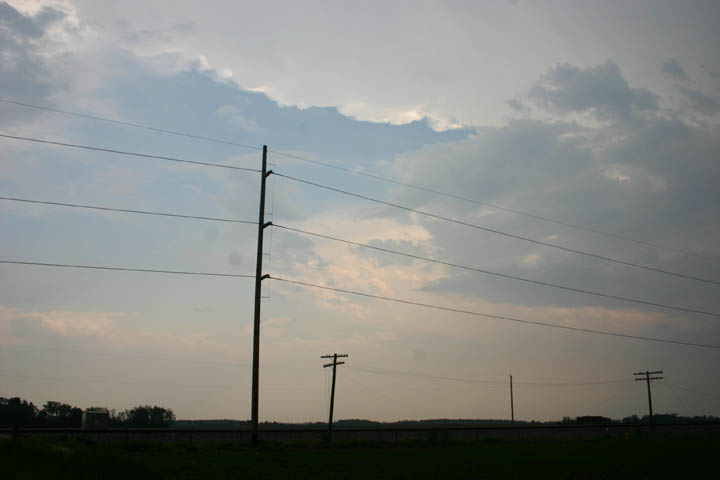
The setup for severe weather looked pretty good across much of Illinois, as overnight and morning convection left an outflow boundary from northeast through west-central IL and on across MO from the northeast to west central part of that state. This boundary was more or less stationary around mid-day and did not look like it would move a lot during the afternoon A low pressure system was passing to the north, with strong upper winds entering from the west. Instabilty was also increasing from west to east, with CAPE ranging from around 1500 in western IL to as high as 3000 in western MO, with increasing instabilty advecting eastward into central and southern IL. Although the synoptic cold front was much farther northwest, the outflow boundary was acting as an effective stationary front, with temperatures in the low 70s to its northwest and the mid to upper 80s to its southeast by early afternoon. With the strong upper jet, there was good speed shear, and there was also some, though not a great deal, of direcitonal shear, with winds ranging from SSW at the surface to due westerly at 250 MB. As the day went on, it became evident that the directional shear and instability would be a little better than it looked like on the previous evening's model run, creating a good setup for supercells, albeit marginal for strong or long-lived tornadoes. A few tornadoes appeared likely, though.
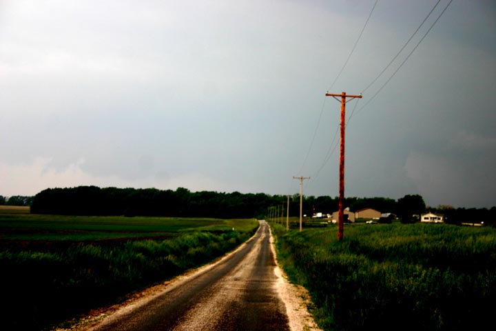
I decided to wait and watch, since I had a lot to do, and the likely action would be pretty close to my north or northwest. Around 2:00, as storms began to develop southwestward along the outflow boundary and a tornado watch was issued, I decided to head out, with a preliminary target of somewhere from Springfield in central IL to Jacksonville, about 30 miles west of there. Once I got close to Springfield, though, it was evident that the best storms were west of there, so I headed west toward Jacksonville.
Storm 1:
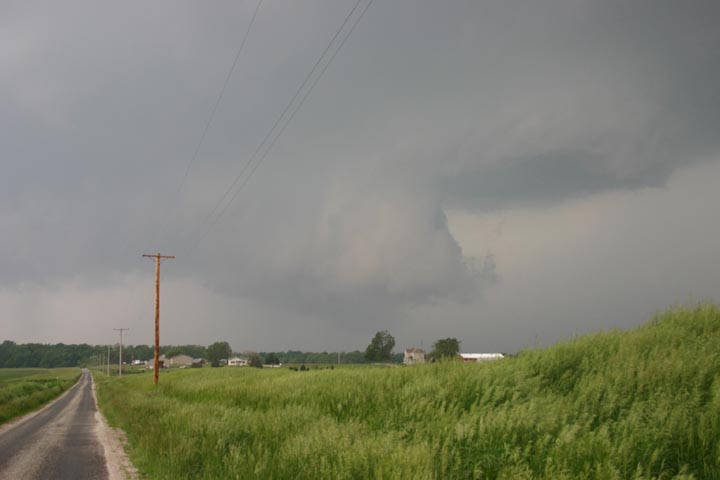
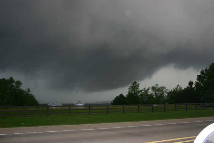
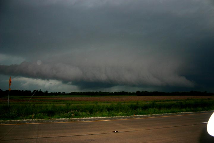
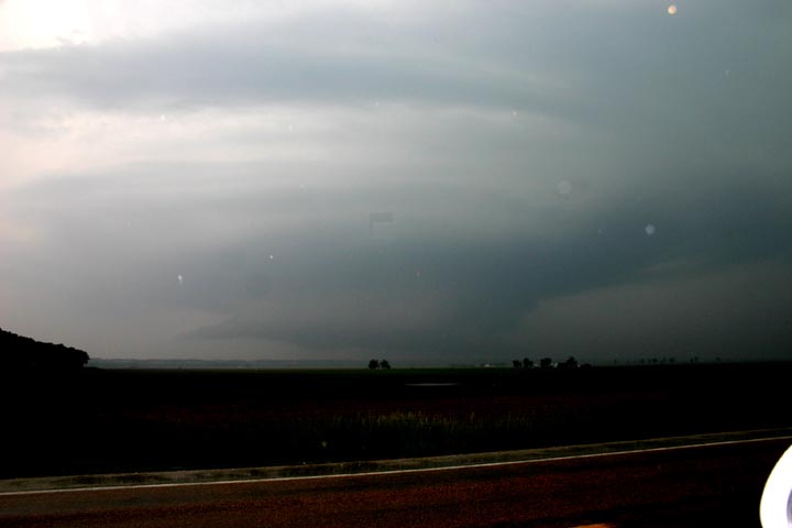
Shortly after 4 p.m., as I was arriving in the Jacksonville area, I heard about a tornado warning for a storm well to my west near Barry in Pike Co., IL. As my batteries were dying in my weather radio, I decided that with the storm that far away (but moving toward me at 50 mph), I had time to stop at the Clark station at the Jacksonville exit and get new batteries, fill my tank, and check data on the station's wifi. A radar check revealed that the storm had a nice hook. I figured I could intercept it just west or NW of Jacksonville, so headed just NW of town on route 67 and waited on a side road a mile or so south of the highway. By 4:25, a new TOR warning had been issued for Morgan Co., where I was located, and for Scott Co. just to the west. At this time the knuckled anvil of the supercell was overhead. Soon I realized I was too far north, so I dropped back to Morton Rd. just west of Jacksonville and set up about a mile west of route 67. Before long, I could see a wall cloud in the distance through the haze. As it moved closer, it was evident the wall cloud was tighening up nicely and looked like it could produce:
As it got closer, there was a lowered area under the wall cloud, as shown in this contrast-enhanced photo:
I thought it possible that a tornado might have been occuring at this time, but none was reported in this location. However, this may well have been a continuation of the funnel cloud that was reported near Exeter at 4:53 p.m. Earlier, between 4:10 and 4:35, this storm also produced 1-inch hail and wind damage to several buildings in Pike Co., IL. A damage survey by the St. Louis NWS has since confirmed that the Pike Co. wind damage was caused by a tornado, which was rated F1, with a path length of one mile.
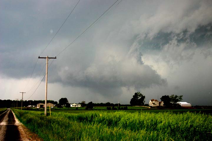
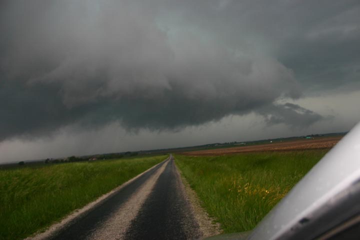
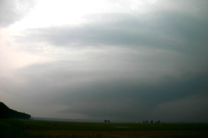
As I watched the wall cloud, it continued to move rapidly eastward, and soon it was time to move east with it, back to route 67. I stopped briefly just before I got there to photograph the wall cloud and the wall of rain and hail behind it, only a mile or so to my north:
Because I-72 curves to the north a bit when it gets east of Jacksonville, I figured that trying to pursue the storm east was not a good option, as I might end up in the core. And besides, a TOR had by now also been issued for the next storm to the west. So after briefly pulling off route 67 (along with a couple other chase vehicles) to watch the wall cloud move over the north side of Jacksonville, where the storm caused some power outages, I decided to head down 67 to I-72 to intercept the next storm. Later, there were numerous reports of hail and funnel clouds, and possibly a brief tornado, farther east in Springfield, probably from this storm, but possibly fron the next one. But now my attention was on the next supercell just to the west of the first one.
Storm 2:
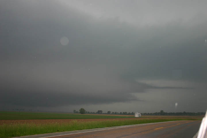
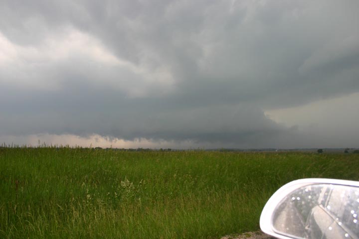
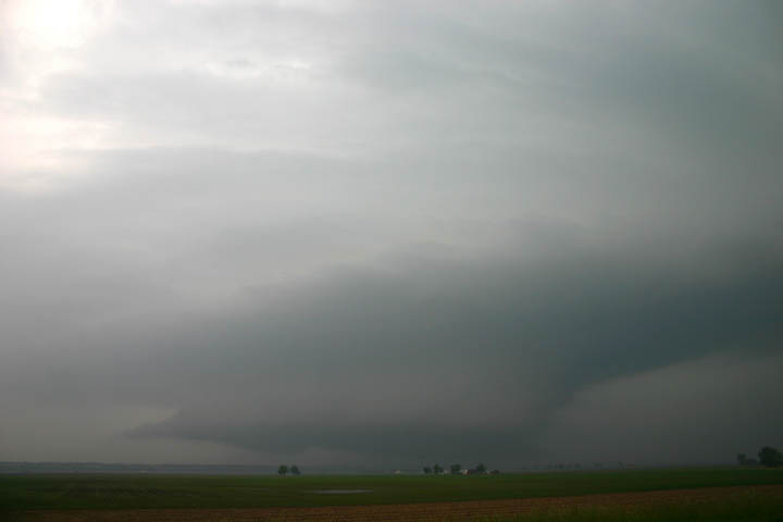
Initially, I considered heading west on I-72 to intercept the next tornado-warned supercell, but decided that by the time I got to the next exit, I would be too far west and either past or in(!) the storm. So I looped around the cloverleaf and backtracked back north on 67 to Morton Rd. again. This time I found a turnoff to the north that took me to a wide, flat valley a mile or so north of Morton Rd., where I had a good view of the next storm, which was tracking just slightly north of the path of the first storm. This storm, like the first one, had an impressive wall cloud. As it got closer, there appeared to be small funnels, first on the front edge of the wall cloud and then on the back edge. Around this time there were spotter reports of a funnel cloud, small hail, and wind damage just west of Chapin around 5:25, in the general direction where these pictures were taken. Soon the wall cloud passed directly to my north, with what looked like a pretty intense rain and hail core on the other side of it:
This storm passed just north of Jacksonville, on a track just to the north of the previous one. By now I was hearing of a TOR-warned storm with a history of producing tornadoes about to cross the Mississippi River.
Storm 3:
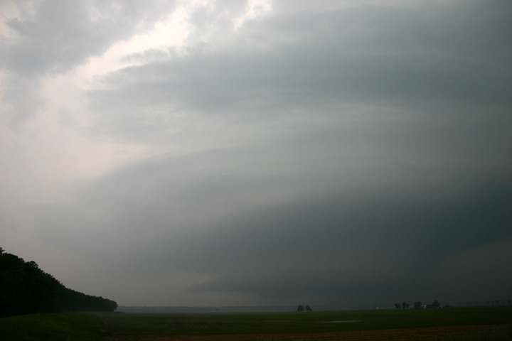
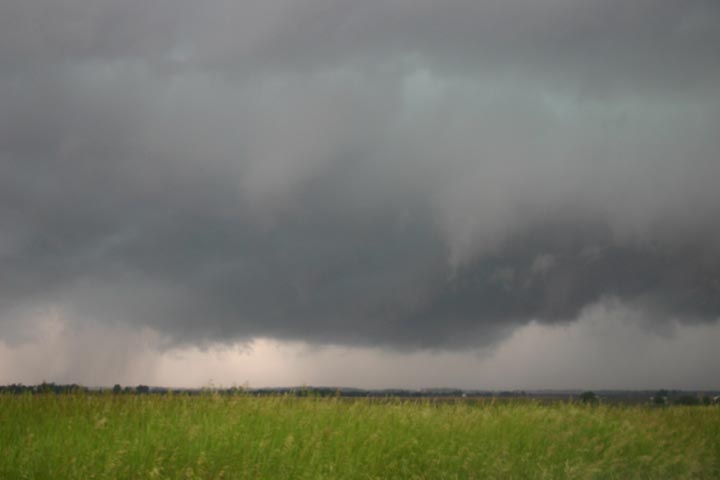
This was the storm that produced the wide, striated wall cloud, resembling the "mothhership" structures Great Plains chasers occasionally get to see:
To get to this storm, which had earlier produced a tornado near Center, MO, I headed west on I-72, as it was only just crossing into IL around the time the second storm passed Jacksonville. I considered exiting I-74 at the Winchester exit, but proceeded west to route 100, then south. I heard reports that it produced another tornado near Summer Hill, southwest of Pittsfield. I started out to head west toward Pittsfield for an intercept, but as I approached the Illinois River, I ran into rain and could see nothing but precipitation ahead. Fearing, correctly as it turns out, that I might have been heading into the core, I decided to turn around at the river and go back to 100 and get farther south. I also did not want to get caught on the west side of the drawbridge, should I need to escape the storm. I went south a couple miles bast the Glasgow turnoff. As a large wall cloud began to appear in the haze, I knew I was a little farther south than I needed to be, so I headed back to just north of the Glasgow turnoff, which is where the picture above was taken. A couple other pictures from the same location can be seen here and here.
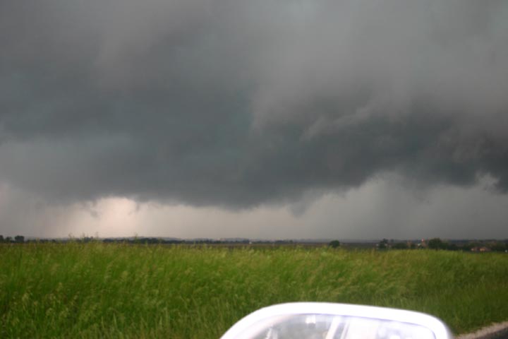
Rather quickly, the wall cloud moved closer. As the leading edge of the wall cloud got close to my north-northwest, some pointy inflow features formed on it:
This picture was taken through the car window, as the CG lightning was getting pretty intense by now. As this wall cloud moved past to my north, I realized that was at least a couple miles across, if not more - one of the largest I have ever seen. I phoned the Lincoln NWS office to report a large, striated wall cloud, then headed east through Glasgow and beyond to try to keep up with the storm. The wall cloud persisted to my north as I blasted east to route 67, where I got momentarily confused by the way the road I was on merged into 67 - I was on the latter headed north before I realized it. This would not do, as I would drive into the storm if I kept going, so I stopped a couple miles north of Woodson. Around this time, the storm cycled, and what had been an RFD gust front/shelf cloud morphed into a new wall cloud:
Storm 4:
Soon thereafter, things got a bit more exciting. After the aforementioned bit of road confusion, I was about to give up the chase at my location a couple miles north of Woodson for lack of an east option. Then I noticed a new lowering with violent motion and some rotation just to my west or WSW. Just then, a minute or two before 7 p.m., the warning on the WX radio sounded to announce a new TOR warning based on rotation 2 miles west of Woodson. As a line of storms behind the supercell I had been chasing was catching up, I could now see a nasty blue-green core coming at me from the west and northwest. I knew I needed to get out of there, so I blasted south on route 67, trying to either beat the meso or thread my way between it and the approaching core behind it. Soon either the lowering I first saw or another one was looming right ahead of me, now a solid, bulbous lowering. I pulled off to let it pass ahead of me, then blasted south behind it and ahead of the oncoming core. The lowering looked to be just a few hundred feet above the ground over the field just to my east between me and the town of Woodson. I really thought a tornado was about to touch down in the field or in the town. As soon as I passed it I was blasted by a dusty RFD that I would estimate around 60 mph or so. No tornado occurred there, but the same storm did produce a series of tornadoes beginning about 12 miles east of my location. The first tornado near Waverly, IL, was on the ground for over five and a half miles, and was the one that Skip Talbot and some other chasers were able to intercept. This cell also produced 3.25" hail south of New Berlin - glad I managed to avoid the hail core! I think that what happened was that a new meso formed west of Woodson when the approaching line of storms interacted with the outflow boundary from the supercell I had been chasing. This new meso turned to be intense and long-lived, becoming embedded in the line of storms and producing the tornadoes near Waverly and eastward into Christian and Shelby Counties, as well as the giant hail south of New Berlin.
All in all, this was an excellent chase, even though I missed the tornadoes. Still, the chase yielded some of the best storm structure I have seen in Illinois.
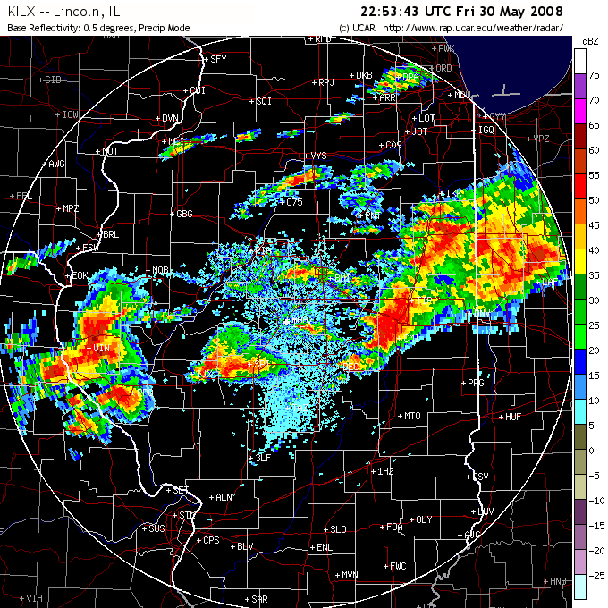
Here is a radar image from a little before 6 p.m. showing the first three storms - all with hook echoes! At this time, the second storm is just east of Jacksonville, while the first one is closing in on Springfield. The third storm has just crossed the Mississippi River into Pike Co., IL, a few minutes before it produced the tornado near Summer Hill.
One other observation - there were more chasers out than is usually the case in IL. There were quite a few on the first storm, and some on the others. A lot had IL plates, but some were from out of state locations, including Oklahoma. I guess it was a combination of maybe more chasers around here than before, and the fact that we (IL and perhaps parts of MO) had probably the best chase setup in the country on this day.