With a back-door cold front having moved across NM from east to west the previous couple days, decent moisture from the Gulf would be returning northwestward across NM, with the best moisture and instability in the southern half of the state but at least 40s dewpoints in the north, with 50s farther south. With some warming of temperatures, CAPE would likely be in the 1000-2000 range. These dews and CAPEs are enough to get the job done in NM with its higher altitude, and this day there would be something that had been missing from most of this year's setups - strong upper winds. A shortwave trough and upper jet max would be moving across NM during the day, with strong southwesterly or WSW upper winds above southeasterly surface winds, creating plenty of wind shear. With this instability and shear, some models were predicting EHIs of 3 and upward in parts of central and southern NM. Supercells would be likely, and tornadoes would at least be a possibility. Storms looked to fire early (during the morning) in the north, perhaps from Cuba to the CO state line, then by early to mid afternoon, also over the southern 2/3 of the state, with probably better moisture and instability to work with. I decided to start early, planning to head initially for Cuba then work my way south to somewhere around Bernalillo or Albuquerque.
The Chase
9:10 a.m. Out the door in Pagosa Springs, CO - Gassed up and on the road around 9:20. Thunderstorms occurring in Pagosa Springs.
10:00 a.m. - Quarter-inch hail just N of 84/64 split west of Chama. Temperature has dropped from around 62 at departure to around 52.
10:12 a.m. - 1/3 inch hail 4 miles WSW of Chama. I got some video of this.
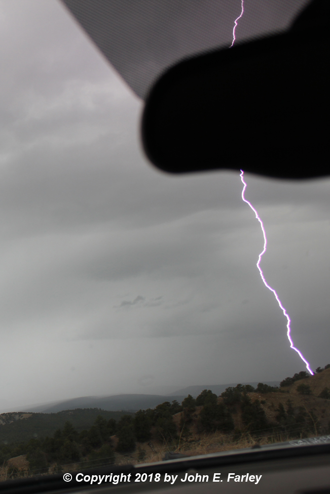
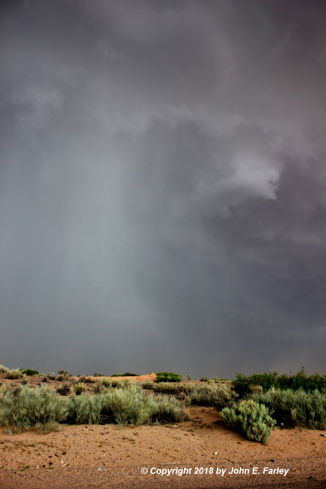
11:00 a.m. - Getting pictures of storms and lightning from the scenic overlook S of Tierra Amarilla. First success of 2018 with the lightning trigger, as lightning strikes a ridge about a quarter mile away. Due to the closeness of the strikes, this lightning was captured through the windshield.
12:40 - Stop at McDonalds in Cuba for lunch and data check. MSD has been issued for NM, west TX by SPC indicating that a watch was likely. On radar I notice a small storm in the Grants, NM area that, though not overly intense, has the shape of supercell. From then to 1:30, that storm blossoms and produces a tornado, and SPC issues a severe thunderstorm watch for central NM from the CO state line all the way south into West TX. I plot a possible intercept of that storm near Rio Rancho or Bernalillo.
I am out of Cuba around 1:30, arrive in Bernalillo around 2:10. I am enough ahead of storm to drop south on I-25 for possible westward intercept of the storm on I-40, though other storms are going up south of the one that produced the tornado. Both that storm and another to its south are SVR-warned.
2:30 - In ABQ on I-25, it becomes evident that the storms are merging west of the city and becoming linear. I decide to go for the tail end storm. As I get south of I-40, I gradually see updraft features on the tail-end storm.
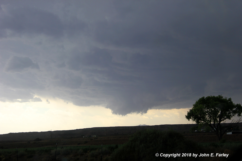
3:00-3:10 - As I am in the Belen area driving south on I-25, a wall cloud and possible brief funnels form under the updraft of the tail-end storm SW of Belen. I stop at the southernmost Belen exit and, from the edge of the on-ramp, get video of rotation and 2 or 3 small, short-lived funnels shortly after 3:00. Here is a picture of the wall cloud:
Video of wall cloud and funnels:
3:25-3:30 - After a longer run than I expected to the next exit, I stop at the Bernardo exit. The storm now looks a little more outflow-dominant as the wall cloud morphs to more of a shelf cloud look, but I see a likely gustnado in the distance north:
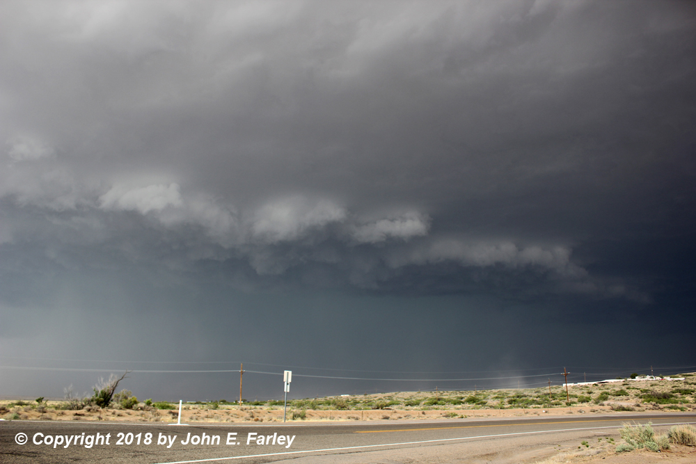
I have seen similar, but closer, pictures of this from other chasers who were sure it was a gustnado, so I am pretty sure it was, though I could not tell for sure from where I was.
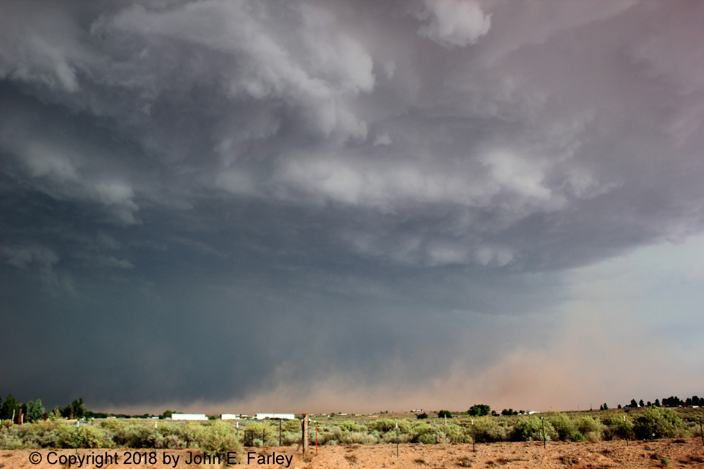
3:35-3:45 - I am now in the hot inflow south of the storm. My car thermometer soars into the low 90s near Bernardo. I go a little east on U.S. 60 then a little north on NM 304 to a couple miles N of the NM Boy's Ranch, then east a mile or so on the Ranchos de Veguita road. I am seeing blowing dust from outflow, with a gustnado or two possibly embedded. About a mile east of 304, I video intense blowing dust just to my NE, blowing SE, around 3:40. Around 3:45 I get a picture of a hail shaft to my north or NNW. Between 3:25 and 3:35 there are multiple reports of 1 to 1.5 inch hail around and just S and SE of Belen. Other chasers photograph 1-2 inch hail accumulations on the ground and on roads. I decide to return to 60 and try to get east to get ahead of the storm.
Here is video of the blowing dust from Rachos de Veguita Road:
Here is a still image of the same blowing dust:
Here is a picture of the hail shaft, just to my north:
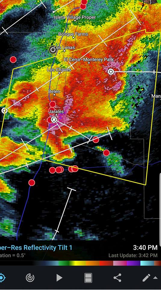
A radar image of the storm from around 3:40, around the time these pictures were taken, can be seen here. Thanks to Jaker Werth for posting this radar image. Note there is a very distinct hook echo - clear evidence this storm was a supercell.
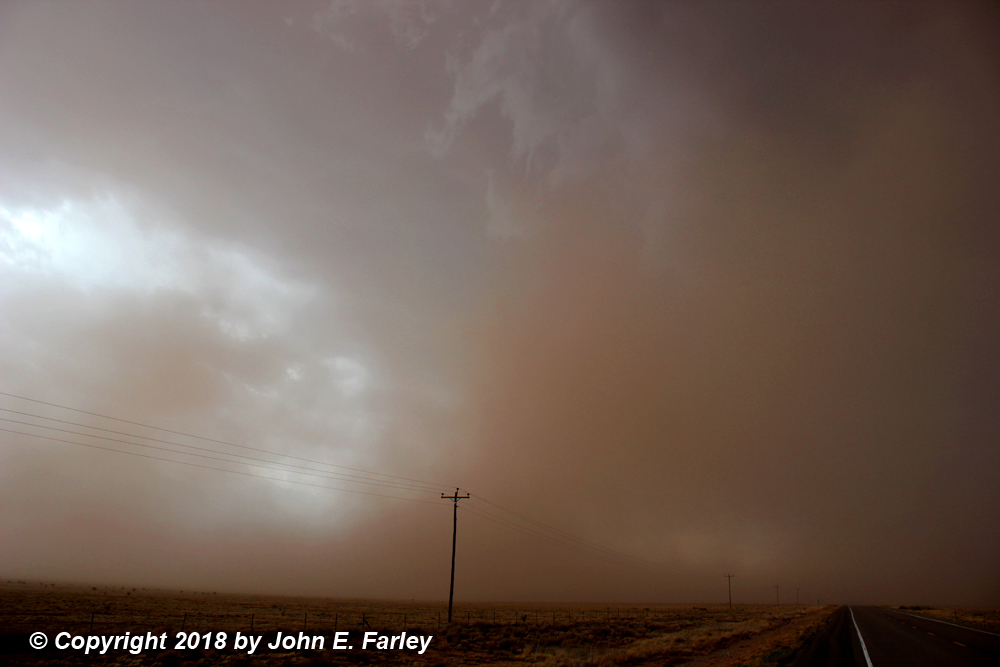
Around 4 p.m. - I thought I could beat the worst of the now-intense dust storm in the outflow as I go east on 60, noticing another gustnado or two in the dust storm to my N and NE. But I end up in the dust storm on U.S. 60 between N.M. 304 and NM 47. In 60-70 mph wind and intense blowing dust, visibility drops to around 50 feet, with tumbleweeds and other small debris flying and hitting my car. This is the most intense dust storm I have ever experienced! And yes, it got quite dark in it, just like they say about the Phoenix haboobs. After several minutes in and out of intense blowing dust, I finally get ahead of it and stop to get pictures and video. Here is a picture from just ahead of the dust storm, looking back to the west at it:
Then a gustnado forms 100-200 yards behind me (to my west) and crosses the road from SW to NE, despite the intense dust blowing NW to SE right behind it. I get video of this gustnado, though it gets lost after crossing the road in the low contrast of gustnado in front of dust storm.
Here is the video of this gustnado:
Here is a still from this video, as the gustnado crosses the road only 100-200 yards to my west:
I see the dust storm closing in on me again from the NW, so I resume going east. Very soon, I see another gustnado in my rear view mirror, and stop and jump out to get video. But this time, I accidentally end up hitting the record button twice, meaning I turned on recording and then turned it off. So no video of this gustnado. It again is only 100-200 yards west of me. It intensifies and moves SE, toward the SW end of the Manzano Mountains (Whiteface Mountain area) a mile or 2 away to my SE. This gustnado becomes very intense with dense swirling dust - I was probably at that time in 40-50 mph northwesterly wind, and there was FAR more dust in the gustnado than where I was, so I have to think the wind in the gustnado was very strong. Between nearness and intensity, definitely the most dramatic gustnado experience I've ever had! It lasts 2 or 3 minutes until it eventually disappears in the surrounding dust storm.
Now, looking back on it, it occurs to me that this COULD have been all one gustnado, with it first crossing the road from SW to NE and then, after I moved to get out of the way of the surging dust storm, getting pushed back to the SE by the outflow and crossing the road just west of me for a second time (after I had moved east), this time from NW to SE. To be honest, I could not tell for sure, because once it was northwest of me after crossing the road the first time, there was no contrast so it was indistinguishable from the large dust storm approaching from the NW. I think more likely it was two separate gustnadoes, but no way to tell for sure. And speculating a little more, I suppose that if it was one feature the whole time, it could even have been a tornado, since if that were the case the duration would have been around five minutes, a little long for a gustnado. But I saw no evidence to call it a tornado, though I could not see much of the cloud features directly above because of all the dust in the air. As I said and you can see in the video, what appeared to be the meso was visible, but a bit to my NW, not overhead. In any case, there were a lot of other chasers in the area, and although there were lots of gustnado reports, nobody reported seeing a tornado in that area.
A few minutes later near the intersection of 60 and 47, I phone in the high wind, blowing dust, and gustnadoes to NWS ABQ. There are quite a few other chasers watching the storm at that intersection. Through this time period the storm has had a very supercellular appearance on radar, with a hook echo. It continues to be SVR-warned, even after warnings are dropped for other storms up the line to its N. I keep moving to stay ahead of the storm.
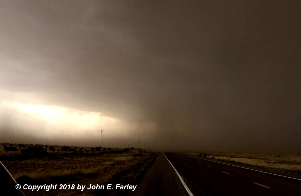
4:00-5:00 - I continue E/NE on 60 to stay ahead of the storm. It becomes more embedded in a line of intense storms, but remains supercellular. I get to Mountainair and stupidly, instead of thinking about gas, keep going to avoid being overtaken by the core. By a little before 5:00, I am approaching Willard, looking at a new lowered area to my NE up the line a little. Here is a picture of that feature:
This feature was northeast of Willard, on the next storm up the line. It was NOT associated with the tornado warning that would be soon issued south of Willard.
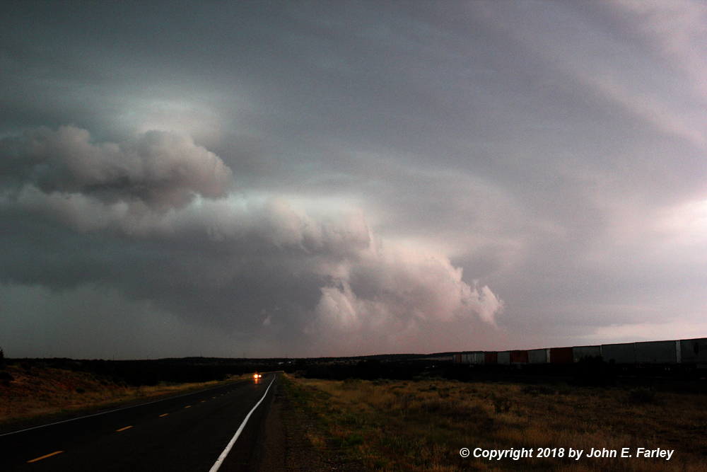
Now realize I am very low on gas, and figure to get it in Willard, but no gas station in the town! I stop at the edge of town and debate going S toward Corona. I figure if I do I might get overtaken by the storm, and if I have to turn around, will be out of gas for sure. I see a couple other chasers head that way. I figure out why a couple minutes later when I see a new TOR warning for the storm south of Willard, but am now on the road (continuing east on 60) trying to get to a gas station in Encino or Vaughan. I see a big, low, round wall cloud to my SW on the leading edge of the storm, in the TOR warning - but do not stop for pictures because I am afraid to stop and waste gas. A little after 5 a tornado is reported - so I saw the meso/wall cloud associated with that report - but was in no position to tell whether there was a tornado. I have since seen a picture of a thin, dusty tornado under the wall cloud (but with no condensation funnel) - don't know whether I would have had any chance to see it if I had stopped and looked hard at the wall cloud. Anyway, I eventually get to Encino, with the line of storms to my N and W, and, guess what, no gas station there either! I really think I will run out before Vaughan, but somehow make it there without running out. Whew!
6:00-6:30 - Since the storm had a new SVR warning that was issued a little after the TOR warning expired at 5:15, I decided to head down U.S. 54 toward Corona to see what I could see. I was very close to the core by the time I reached Duran, so I stopped there. The storm did produce a couple lowerings south of Duran, but they seemed scuddy (to the extent that I could see them through the rain and the trees, which are more numerous here) and no real threat. And by then, getting close to 6:30, the SVR warning had expired and a new one was not issued immediately. So I bailed back northeast, getting overtaken for a while by the leading edge of the line of storms, with more pea-sized hail. But once I got back to 285 I was northeast of the heaviest part of the storm, and just had rain after that as I called it a night and headed up 285 to Santa Fe.
Here is a map showing the route I took to observe this storm, where I saw various storm features, and local storm reports from the NWS:
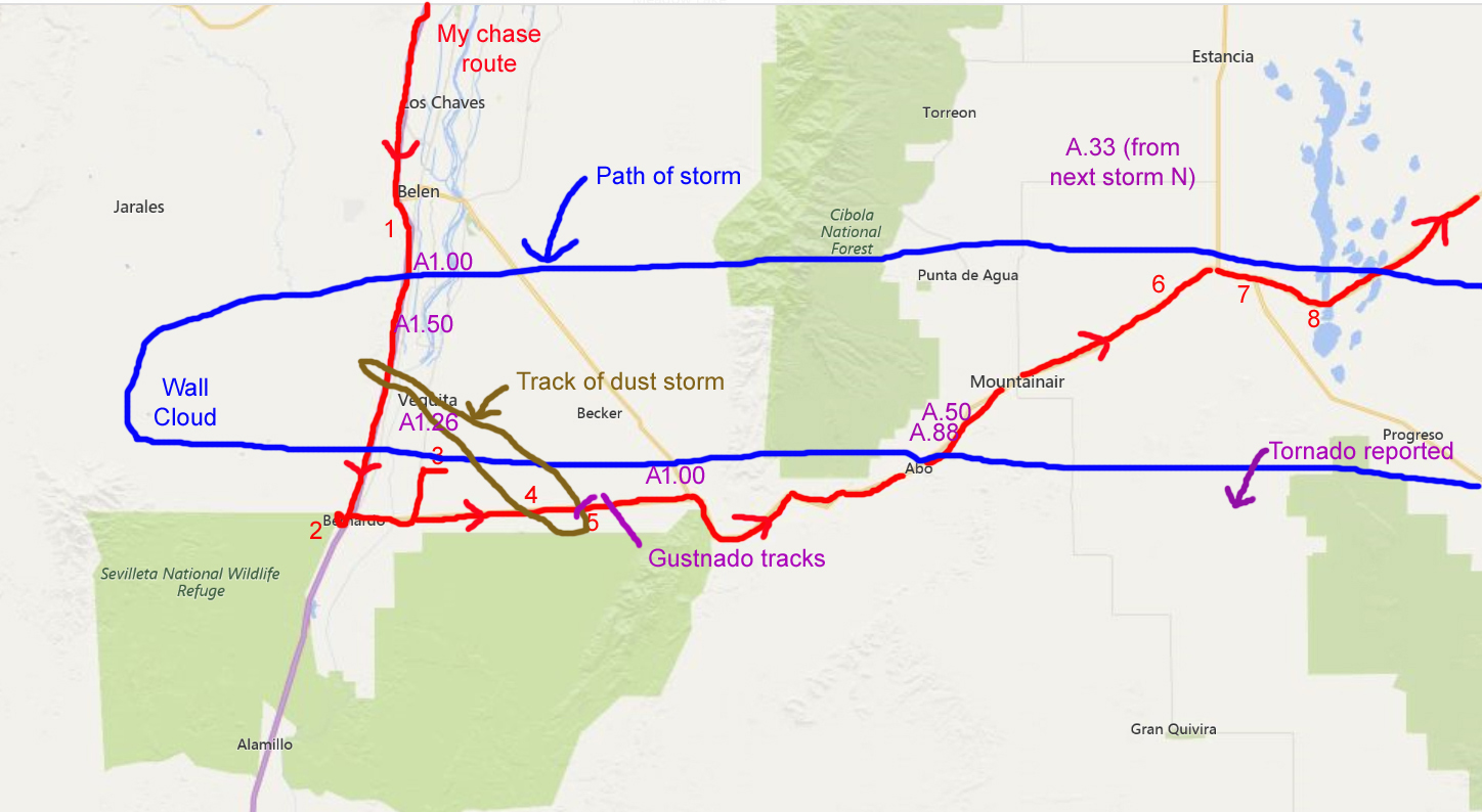
Key to numbers on chase route map:
1. Watched rotating wall cloud and brief funnels from here, looking SW.
2. Watched storm to my north from here, with possible gustnado.
3. Watched intense dust storm from here. Dust storm was a little to my NE.
4. Drove through dust storm here. Very high winds and visibiltiy under 50 feet at times.
5. Viewed gusthnadoes from about here. Both passed within 100-200 yards of my location.
6. Viewed lowering to my NE from here. Lowering was on next storm up the line.
7. Realized now that I was very low on gas. Thus, did not go south toward meso of storm I had been chasing.
8. Looking to my SW, saw the large, round wall cloud associated with the tornado/tornado warning. Did not see the tornado.
Total chase distance: 521 miles.
Return to 2018 Severe Weather Observation Page