
The setup: There were two boundaries of interest. One was an outflow boundary from overnight and morning convection, alligned roughly along a curved line from south of St. Louis to south of Washington, MO to just southwest of Columbia to just north of Kansas City. The other was a stalled front (or actually kind of a hybrid of the stalled front and convective outflow boundaries) roughly in the U.S. 36 corridor, from just south of Hannibal to around or just north of St. Joseph. This stalled cold front would gradually start to work north again as a warm front as low pressure approached from Kansas. SPC saw this as the main play, especially in NW MO, but I also had my eye on the southern outflow boundary, because the HRRR model was showing convection forming along it and because it was in the area of better instability, with CAPE in the 2000-3000 range. With southeasterly surface winds, both boundaries would have decent directional shear, with upper support stronger to the west. Thus, it appeared to me that if storms fired along either boundary, supercells were possible.
I headed out around 11:45. After checking data in Wentzville, I decided to stick close to the southern boundary as far as Columbia, where I had a good north option on 63 if the northern boundary worked out to be better. While the HRRR fired convection in eastern MO along the southern boundary, it did not have much in northwest MO, where the RUC was predicting an EHI as high as 10 - but again with some doubts about whether storms would initiate in that area during the day. It was clearly that area that SPC was most interested in. When I got to Columbia and after a short pit stop, I noticed on radar that a single intense storm had formed about 50 miles north of there in Macon County, on the northern boundary. But storms also appeared to be initiating one county west of Columbia on the southern boundary, so I continued west - until the storms croaked when I got to them 20 minutes later. Meanwhile, the single Macon County storm was still going strong, and since it was only moving about 25 mph I figured I could get to it if I reversed course, which I did. After returning to Columbia and blasting north on 63, northeast on 24, and north on 15, I beat the storm to Shelbina by about a minute - but from there I would be able to stay ahead of it on route 36 for the rest of the way across MO and into IL.
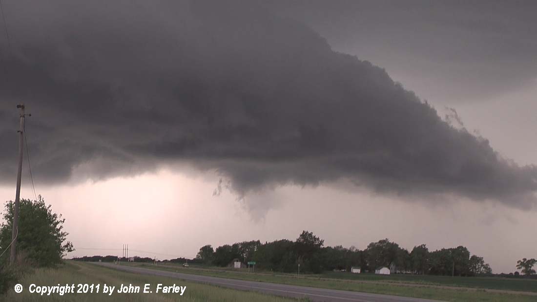
When I reached Shelbina, the storm had a wall cloud, but it was a little less intense than it had been earlier in Macon County and promptly began to look more outflowish, with the wall cloud quickly dissipating. However, I stuck with it, and eventually around Monroe City the storm began to look more organized again. Gradually, it formed an elongated lowered area under the updraft, and took on a very menacing look:
Periodically, new bursts of precipitation would come down behind the lowered updraft base. While I was watching the storm from about 10 miles west of Hannibal, a strong rainfoot appeared, the first of several times this would occur. Also the storm formed a couple lowerings (pictures here and here) under the lowered updraft base that reached at least halfway from the base to the ground. One of them briefly - for maybe one minute - took on the appearance of a funnel cloud (look just to the right of the orange sign):

However, for the most part the motion in these lowerings was vertical, not rotation. As the storm was about to catch up, I needed to move east again, and since it is wooded and hilly in the immediate area around Hannibal, I decided to continue east and view the storm from the Illinois side. The first exit with a clear view across the flat flood plain was about 10 miles east of Hannibal, a little more than I wanted, but it afforded a clear view of the storm for quite some time. The storm had been gradually developing southward, giving its track a slight right or southeastward turn. It was clear that the updraft would pass south of Hannibal, and that much of the hail core would pass right over Hannibal. By the time it reached Hannibal, the storm had clearly intensified, which was evident both visually and on radar. Here is a video capture of the storm as it moved over Hannibal.

Soon after this, I noticed another rainfoot, and scud rapidly formed right above the rainfoot, and was gradually drawn up into the updraft, creating a lowering under the base. Then another, even more intense rainfoot formed under this lowering, and another scud cloud formed on the top of the rainfoot and also began rising to meet the lowering above it:

The right-to-left (NW-SE) movement of the rainfoot was very pronounced at this time, and I knew the storm was producing very strong wind. Here is a video of the process, taken from about 6:11-6:13 - view this full-screen and in HD if your connection speed allows:
In the local storm reports, note that the most serious reports of wind damage, including multiple homes unroofed, billboards down, large trees down, etc. are in the 6:10-6:13 timeframe - the same time I was taking this video. A local television report on the damage to one home can be seen at:
http://www.wgem.com/Global/story.asp?S=14879670
I would think, based on the damage to the home and other damage that occurred, that the peak wind may have exceeded 100 mph. The video is strongly suggestive of a microburst - note that, at the ground level, the rain, hail, dust, etc. are being blown from right to left, and ground-level rotation is not evident - although there could be a little in the cloud tags above. The TV story does mention an abrupt shift in wind direction, which might suggest a tornado in there somewhere - and I suppose that is possible, since I was 10 miles away, but the wind switch could also have been from inflow to outflow - I did notice pretty fast changes from easterly inflow wind to westerly outflow wind a mile or two ahead of the storm a couple times along route 36. In any case, it was a very violent storm, and my location to its east turned out to be a very good one for geting nicely backlit video of the surging rainfoot and lowering.
UPDATE, 6/12/11: A damage survey by the National Weather Service has confirmed that the damage was the result of an intense microburst, with wind that may have been 100 mph. Two public information statements summarizing this damage survey can be found here and here. It is notable in the second, more detailed statement, how the intense wind of the microburst fanned out all directions, with damage to the west of the apparent center of the microburst involving a roof and trees being blown in a westward direction, while across the highway to the east, trees were blown down in an eastward direction. The statement also mentions the microburst being on the back side of the storm, which supports something I suspected from my video - the microburst was likely associated with a rear-flank downdraft.
After the storm reached the Mississippi River, it rapidly dissipated and the chase was over. I think it got just far enough on the cool side of the frontal boundary to lose its unstable inflow, and that was the end of it. Meanwhile, a number of supercells did develop westward along the frontal boundary all across Missouri.
In addition to the severe wind damage just west and south of Hannibal, the storm produced numerous reports of 1 to 1.5 inch hail across the Hannibal area, with hail covering the ground in some places. Earlier, in Macon County before I was on the storm, it produced baseball hail in one location, and some wind damage, too. In fact, the hail damage in Macon County may have exceeded $100,000, according to local media reports. Between there and about 10 miles west of Hannibal, the reports were mostly small hail and 35-40 mph wind, during the phase while the storm was weaker and more outflow dominant. But it then intensified quite dramatically in the Hannibal area, perhaps as it crossed the frontal boundary. The other storms to the west were apparently rather similar to this one, in that they produced a lot of hail reports and some wind damage reports, but apparently no tornadoes. In fact, the only tornado in the day's preliminary LSRs anywhere in the U.S. was near Wichita, KS.
A couple interesting notes - just after the intense Hannibal rainfoot, I had a nice visit with a police officer who stopped to check what I was doing. He was very interested in the weather and in where in the storm to look for a possible tornado - I'm guessing he hadn't had spotter training recently. I tried to explain the concept of scud over a rainfoot without using too much jargon - not easy. Then shortly later after I left to move farther east I noticed a tour group consisting of two white vans and maybe 20 guests at the same exit where I had gotten off - a little surprised to see them that far east today, but they did end up getting a good storm. Later, as the storm fizzled out west of Pittsfield, I also noticed someone photographing its remnants that had a mesonet on top of their car. So there were definitely a few chasers in the area today.
Total chase distance: 439 miles.