The Setup: A backdoor cold front had been stalled for a couple days along the front range. There was now an increasing amount of returning moisture behind (northeast of) this now stationary frontal boundary. Good instability appeared likely northeast of the boundary, with CAPE forecast as high as 3000 or more on Colorado high plains, with the best instability forecast in the far northeast part of Colorado, i.e. NE and E of Limon. Moisture in this area would be decent by Colorado standards, with dewpoints forecast in the 50s to low 60s in the northeast and far east part of the state. Decent directional shear would also be present, with a SE surface wind veering with height to WNW in upper air, although the wind would not be strong at all levels. Supercells appeared likely, and maybe a tornado or two.
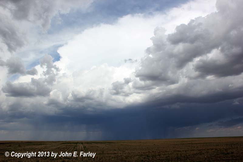
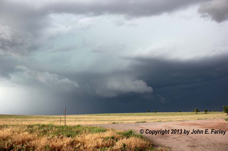
The Chase: After overnighting in Pueblo, I started out with target of just east or northeast of Limon. A strong but high-based storm went up early (before 10:30 a.m.) north of Colorado Springs, perhaps near Monument. As I worked my way northeast toward Limon, I decided to head north to get closer to storm, which started moving ENE but turned to E and eventually ESE. This storm stayed high-based with some CG and eventually a very spread-out anvil, but did not intensify. Nearing Limon, noticed that cumulus clouds NE of town were beginning to grow. By the end of lunch, a couple had evolved into large TCU NE of Limon (around 1-1:30 p.m). This was in exactly the area I had identified as my chase target for the day.
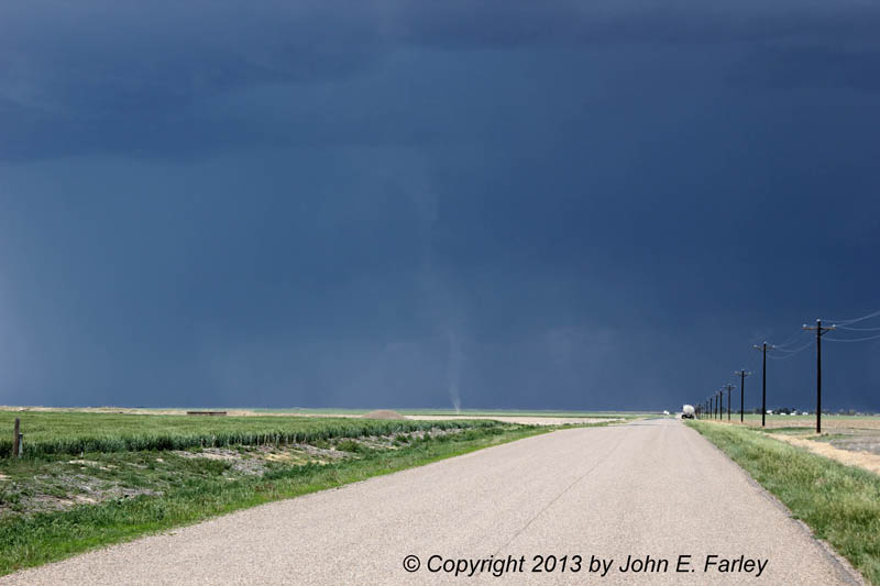
I decided to go after the TCU, which quickly became CB. Precipitation from this new storm began to appear on radar, and after a while, CG lightning started to appear. By around 2 or 2:15 p.m., the storm was SVR warned. By this time, I was headed north from Arriba to intercept the storm, beginning the 3+ hours that I would be tracking this storm. Soon I noticed several areas of dust blowing toward storm in the increasing southeasterly inflow, but it was evident that some of the dust was being stirred up by farm equipment. However, after 2:30 or so, I began to also notice whirlwinds in the inflow, including this particularly impressive one around 2:45:
I thought at the time that this was a gustnado. Later some who saw this picture after I posted it on Facebook thought it might have been a landspout. After reviewing video, I am pretty convinced it was neither. Rather, it was a large dust devil that formed in the storm's inflow and was pulled toward the storm, and stretched upward by the inflow into the storm, which was now becoming a supercell. It was not a gustnado, because it was entirely in the inflow, not at the juncture of inflow and outflow. And it also did not appear to be a landspout, because it was not connected to the cloud above; in fact it was located slightly ahead of the cloud base. Rather, I believe that it was a strong dust devil that formed in the inflow, and then interacted with the storm as it was pulled upward and toward the storm by the storm's inflow. This process is well-described in the following SPS (for another day) from the Pueblo, CO National Weater Service:
OCCASIONALLY...DUST DEVILS MOVE INTO AN AREA OF UPDRAFTS OF RAPIDLY
BUILDING CLOUDS. THE RESULT CAN BE AN INTENSIFICATION OF THE DUST
DEVIL CIRCULATION...WHICH DEVELOPS INTO A SHORT-LIVED TORNADO.
Except, of course, that this one did not develop into a tornado, because, so far as I could see, it never made a connection with the storm's updraft base. A short video clip of this dust devil appears a little farther down in this report, along with video of a true gustnado that occurred later.
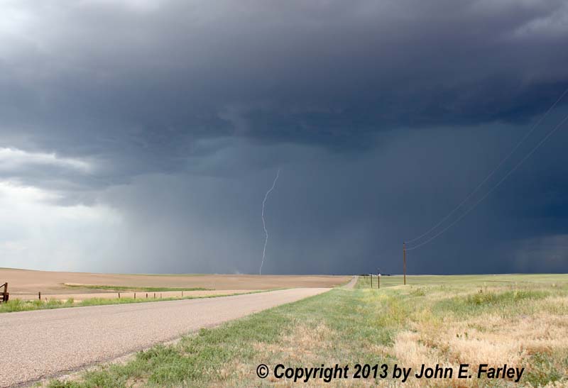
The storm continued to intensify, putting down a lot of CG lightning. Note in this picture there is also a plume of dust to the left of the lightning, being blown toward the storm by the inflow, and possibly a dust devil or gustnado to the left of that - a little too far away to tell. But there were several occurrences of both dust devils and true gustnadoes over the course of the time I was on this storm, it so certainly could have been. Although the initial motion of the storm had been to the ENE, it gradually turned to the right, moving E, then ESE, and eventually SE. Also, early on it split, sending a left split racing NNE, which also became severe. But I stayed with the main storm/right split. As it turned toward the SE, I stairstepped the section roads east and south to stay ahead of it, eventually seeing this gustnado to my west somewhere north of Seibert:
Unlike the feature in the earlier picture, this was a gustnado, because it formed along the boundary between the southeasterly inflow and the westerly outflow. Here is a short Youtube video showing both this gustnado and the dust devil that earlier formed and interacted with the storm:
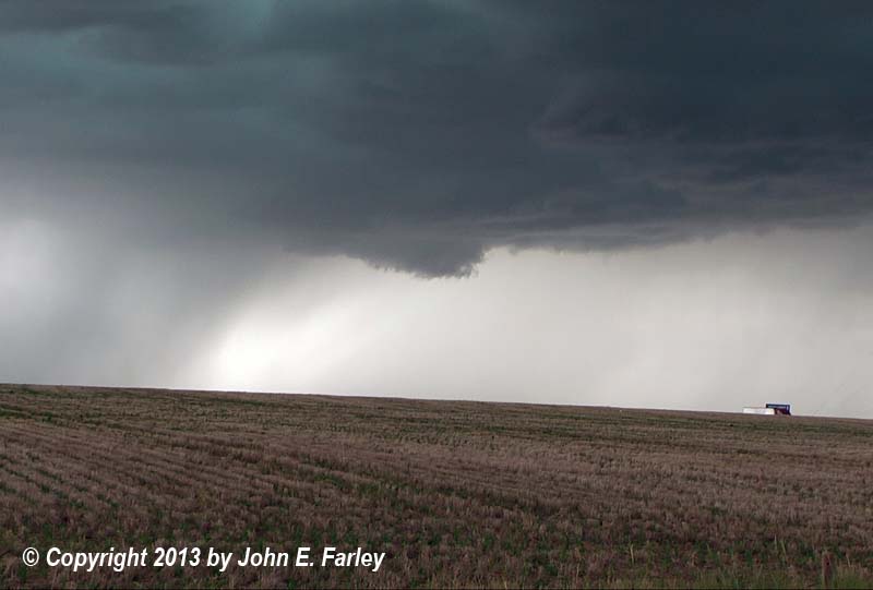
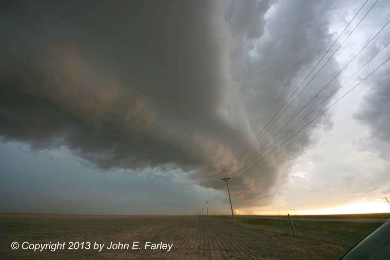
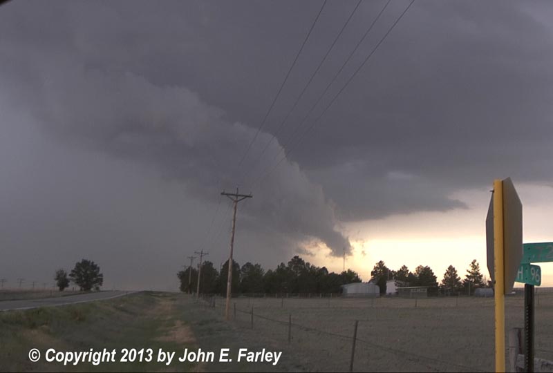
I continued stairstepping SE ahead of the storm. North of Vona, clear cloud-base rotation was evident, at the time when I took this picture. This was the first of at least 3 times when I could clearly see storm-scale rotation; each seemed to be with a separate cycle of what had become a cyclic supercell.
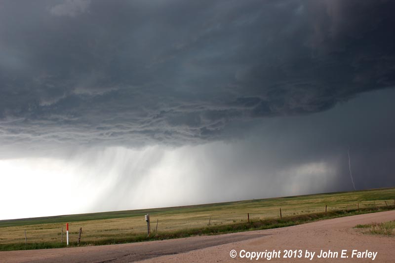
When I eventually reached I-70, I got on and went east ahead of the storm to the Bethune exit, where I got off and watched it approach. Another chaser came along and stopped, only the second one I had seen all day (and the first one was on the earlier storm, between Colorado Springs and Limon). He came over to chat about the storm, and it turned out to be Stan Rose, someone I was familiar with online but had never met in person; we had a nice visit. After we watched the storm, which was rotating again, and visited for a while, he decided to head east and I headed south, as we chose different strategies to stay ahead of the storm. It cycled for a third time and formed a bit more of a wall cloud, with definite rotation visible:
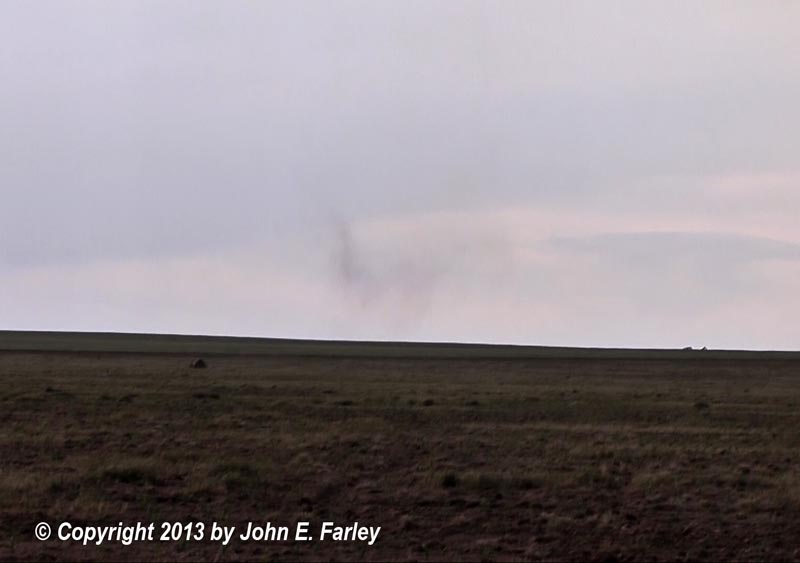
But also notice that there is now heavy precipitation to the left (south/SW) of the wall cloud - the storm was evolving into HP mode. Around the time I took this picture or just after, the storm - which had continuously been SVR warned since shortly after I got on it - got its first and only TOR warning. This was based on a report of a tornado 10 miles S of Stratton, perhaps 5 miles SW of where I was. Later in the LSR, it was listed as a landspout reported by a chaser 13 miles SSE of Stratton, at County Road G and County Road 26. I suppose there could have been - if there was, the rain left of the wall cloud was obscuring it from my viewpoint - but I am a little skeptical. In most places past just left of the wall cloud - i.e. in the area where I think the tornado would have been based on its reported location - you could see through the rain, and I saw nothing. So I will kind of believe it when I see a picture, which I have not. And with all of the dust devils, gustnadoes, dust plumes from both inflow and outflow, and rotating wall clouds that this storm produced, there was a lot that could have been mistaken for a tornado.
An interesting aside here - I am always amazed at how chasers come out of the woodwork once a storm has a TOR warning. As I mentioned, before the TOR was issued, I had seen only two chasers all day - one on the earlier storm, and Stan Rose on this one. But within 10 minutes of the TOR warning, I saw a tour group and a caravan of 5 or so chase vehicles, all coming in from the east on a side road. Never seems to fail!
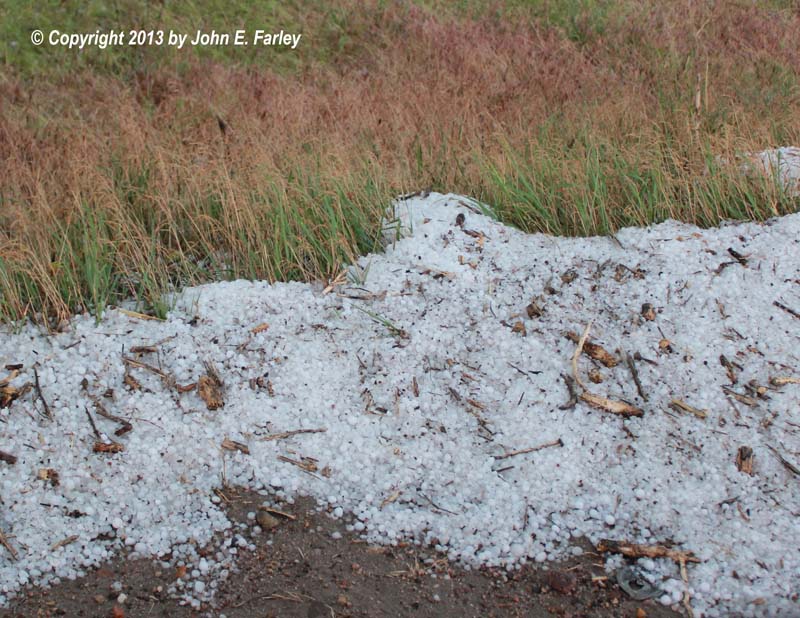
A new storm had gone up southeast of the main supercell and moved northeast toward an eventual merger with the supercell. I was between the supercell to my W/N and the new storm to my SE/E on the north-south County road 40 south of Bethune, approaching the E-W road 10-12 miles S of there (County Road G, I believe). The new storm looked very intense and appeared to be kicking up some dust ahead of its small but intense core. I turned east on road G and crossed behind the new storm, and encountered a swath a mile or so wide where the ground was partially to almost completely covered with hail and fields flooded. The hail was drifted in places. Most of it was dime-sized or smaller, but a handful of stones were up to quarter-sized (1-inch diameter). I headed east to route 385 and turned south to stay ahead of the main storm, as the storm that had produced the hail was absorbed into the main supercell. Now in the outflow, I observed wild cloud motion in scud that formed near the ground and near the inflow-outflow interface.
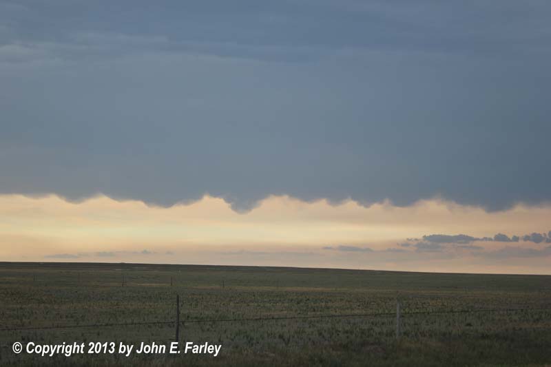
I stopped one last time where 385 briefly jogs west before heading south to Cheyenne Wells to view the storm. Here is my final look at it:
With the storm now due north of me, moving SE into a less than ideal road network, and HP, I knew my chase of this storm was about over. But now a new supercell had popped up farther to the SSE, just southeast of Cheyenne Wells:

This cell appeared on radar to be moving quite slowly, so I decided to go after it by heading south from Cheyenne Wells and hoping to eventually head east on route 96 for an intercept. As I entered Cheyenne Wells, the new supercell went TOR-warned, based on radar-indicated rotation. It took quite a while to catch up to the storm since I was chasing this one from behind, but with its slow movement I did manage to do so along route 96 between Sheridan Lake and the Kansas state line. But by now the storm had become somewhat more outflow-dominant, and the TOR was replaced with an SVR. I approached the SW edge of the storm as it moved SE across route 96 toward Kansas. The storm formed an intense gust front, which I presume originated with RFD but now was becoming elongated. To my north, big dust plumes were racing SW, and to my NE, even bigger ones raced S. I got video of these from outside the car as they approached, and from inside once they hit. A view to the east just before the surging gust front hit can be seen here. Soon I was hit by intense wind and blowing dust that reduced visibility to about 1/4 mile. A spotter a few miles west of my location measured a 71 mph gust; I would guess it was similar where I was but it really looked most intense to my east, not my west.
Video of the high wind and blowing dust:
Remember the storm I had been chasing in the morning between Colorado Springs and Limon? Over the course of the day, this had combined with other storms SE of Colorado Springs to create a very large complex of storms over a huge area of SE Colorado. This complex was now just to my southwest, and before the gust front hit, I had noticed some rather impressive mammatus off to my SE from this complex of storms. As the tail-end of the gust front that moved over me surged to the southwest, it began to interact with outflow from the storms to the southwest, and when this happened, with the help of the lowering sun, it produced a spectacular result:
Looking at this view toward the west, you might think that this was a storm approaching me from the southwest, but actually the arcus cloud had just passed over me from the NNE. At the time of this picture, the arcus cloud was effectively being shaped by outflow from both directions, causing it to stall and change its curvature to conform more to the shape of the storm to the southwest. This is one of my favorite images of this chase season; I call it "When Storms Collide."
After this, I knew the chase was over. Rain and storms were now occurring nearly every direction from me, and darkness was approaching. I figured my best bet for getting a room and being in position for the next day's chase, which at the time I thought would be in SE CO or NE NM, would be to head south and a little west to Lamar. I arrived there shortly after 9 p.m. after driving in rain and occasional wind for 45 minutes or so, and was startled to see police blocking many of the roads in town. Turns out there was widespread flash flooding from a quick 2 inches of rain, and both the main route and the truck route of highway 50 were under water. Eventually I found my way through town and managed to find a room. The next morning, a local chaser was visiting with hotel employees when I checked out, and he showed me pictures he had taken of intense blowing dust similar to what I encoutered east of Sheridan Lake, and of a funnel cloud. All of these were taken near Lamar - a town that went from drought to severe weather and flash flooding in a very short time!