On the morning of the 19th, though, it was increasingly evident that conditions could be quite favorable for tornadoes later in the day, especially over west-central Illinois. The atmosphere was already quite unstable by late morning, with CAPE as high as 2,000 j/kg over parts of eastern MO and western IL. And the morning forecasts on the RUC model showed virtually every parameter favorable for tornadoes in west-central IL during the afternoon. The instability would continue and perhaps even intensify a bit, with CAPE of 2,000-3,000 predicted during the afternoon. Additionally, with surface wind from the southeast and upper wind from the southwest (and rather strong just to the northwest, with IL in the right exit region of a strong jet over northern MO and eastern IA), there would be good directional wind shear - a crucial ingredient for rotating thunderstorms that can produce tornadoes. Also, the LCL and LFC would be low, meaning that the instability and storm clouds would be close to the ground, enhancing the chance of tornadoes if rotating storms did form. And finally, a warm front - somewhat diffuse but a front nonetheless, was working its way northward and would move through the area of interest during the afternoon, further enhancing the chance of strong storms and of locally-maximized potential for storms to rotate.
By shortly after noon, storms associated with a mesoscale convective vortex (an area of localized low pressure induced by storms overnight and in the morning) were intensifying over northeast MO as they moved northeast and backbuilt toward the south. I knew it would be time to leave soon, as these storms could become supercells as they moved into the favorable environment in west-central IL.
I left home around 12:30 to head north from Edwardsville, expecting to intercept the storms somewhere near Jacksonville, IL. I went north on route 159, west on 16, and north again on 111 and 267. As I got farther north, I could see two powerful looking storms to my west and northwest. The storms looked good, with backsheared, knuckled anvils on both. The more northerly one looked stronger at first, but I doubted my ability to intercept it. But the one more to my west was intensifying, and since it was the southernmost strong storm in the line I thought it actually might have more potential to intensify as it would ingest the most unstable, juicy air without interference from other storms. A little before 2 p.m. I could see that the storm's updraft was to my WSW, and feeling that I needed to get closer to the storm, I decided to head west on the road to Roodhouse. From there, I could hopefully go northeast on route 67 and maintain position on the storm. Although the latter did not entirely work out, going west to Roodhouse turned out to be a very good choice.
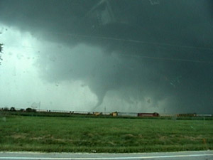
Up to this point in the chase, I had no data other than what I could see, because I could not get an internet connection with my aircard. Even the weather radio had been of little use, because the stations I was getting were from my south, where the storms were not threatening. But as I approached Roodhouse, I finally picked up the Jacksonville station and learned that the storm I was approaching was already tornado-warned. As I came into town, I could see ragged lowerings in the distance, but the contrast was at that point rather poor and trees and tall corn often blocked the view. I got to route 67 in Roodhouse and turned right, heading out of town toward the NNE. Now the storm was going to town and CG lightning was zapping down all around me. About a mile or so north of town I found a spot where my view was not obstructed by corn. I could see two areas of interest. The first one, which I saw first, appears to have been an occluding mesocyclone off to the northwest, with a couple lowered areas and intense precipitation just to its northeast. However, I soon noticed another area of interest farther south, which appeared to contain a rain-wrapped lowering. This turned out to be the feature that produced the tornado. I had a rather narrow view looking WNW between a cornfield to my north and a grove of trees just to the south of where I was parked. Soon, rain curtains emerged from behind the trees, likely rotating around the lowering behind them. Then the lowering emerged, becoming quickly evident that it was a large funnel or possibly tornado, with a very pronounced RFD (rear-flank downdraft) evident. This occurred at 2:15 p.m. Almost immediately, a condensation vortex spun up into the large funnel from the ground just below it and to its left - tornado!
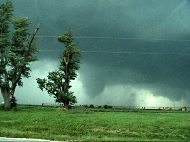
A few minutes later, a second, larger vortex again spun up into the main funnel from the lower left:
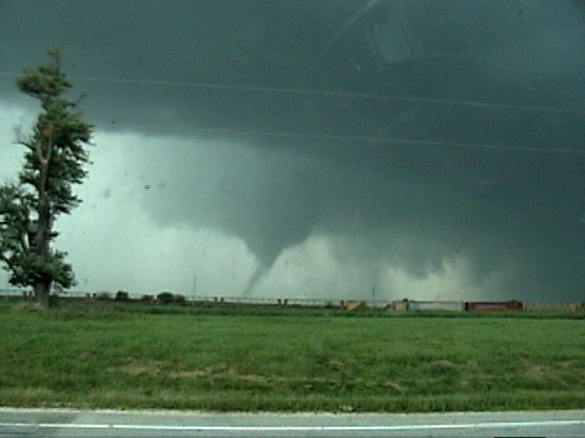
After this, the tornado took on a curved, elephant-trunk appearance:
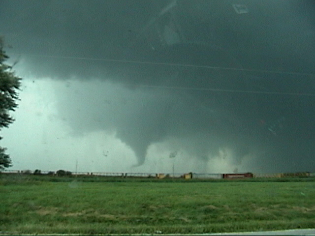
And then, the condensation extended back down to the ground:

All of the pictures above are video captures. I apologize for the splotches; with the CG lightning zapping down, I was keenly aware of the chaser struck while videotaping through an open window a week or so earlier, so kept the window shut.
Youtube video:
Although the storm already had tornado warnings for parts of Greene, Scott, and Morgan Counties, I wanted to let the National Weather Service (NWS) know there was in fact a tornado, so I called it in to the Lincoln, IL NWS office. At this point the tornado was most likely still in Greene County, for which the St. Louis NWS office has responsibility, perhaps close to the tiny village of Barrow. However, since it would very soon cross into Scott County, which is Linconln's responsibility, I thought it made more sense to call them. The tornado disappeared into the rain, but I followed the now rain-wrapped tornado up route 67 hoping it might re-emerge from the rain. It did, at least enough for me to be able to see it again through the rain, as I approached the town of Manchester. The tornado appeared to be crossing the road a mile or so ahead of me. I tried to get some video, but the rain closed in again before I could - the tornado was visible for less than a minute this time, but in contrast to the earlier view it was front-lit by the sun so it was actually an off-whitish color, lighter than the background. It also looked larger than before, though mostly I could just see the left edge of it, as the right side was more blocked by rain. I pulled over at the Manchester exit and called the Lincoln NWS again to let them know the tornado was still on the ground and was near or just north of the town. Just then another driver who had been pulled over ahead of me just past the ramp backed up to tell me he had nearly driven into the tornado, and had "backed up at 30 mph" to escape it. Seeing later the damage done to signs along the road, I think it is a good thing he did!
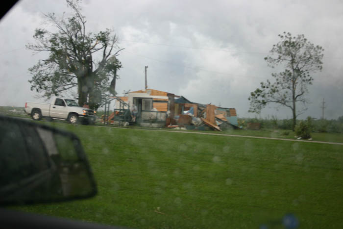
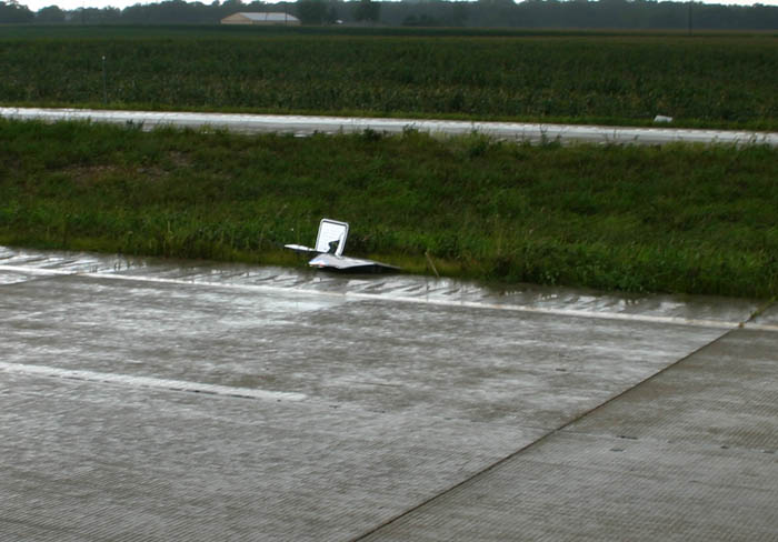
After calling the NWS, I proceded through the town, partly to see if there was any damage, but also partly to see if I could find a road to the east to regain position on the storm. However, when I got to the northeast end of town, I encountered considerable damage and figured it was time to stop and see if assistance was needed. The worst damage was to this mobile home, which was pretty much destroyed. There were wires down on the road, trees and branches down all over, and at least minor damage to one or two frame houses. A police officer was already there, and at that point unsure whether he needed my help. I warned some people about the downed lines, and was able to determine that the occupant of the mobile home - who was in it when the tornado hit - although shaken, was not seriously injured, and was being cared for by her neighbors. I decided to proceed cautiously. The road took me back onto route 67, where I soon stopped to assist again when I discovered that a road sign had landed in the road. I dragged it over to the median so nobody would hit or drive over it. It was one of those signs with the metal posts - I saw 4 or 5 of these that were blown over, some flattened entirely to the ground. But this one had broken off entirely, gone flying from who knows where, and landed in the left lane of the divided hightway. After moving that off the road, I started again, but stopped for a third time when I saw utility poles down across the railroad tracks along southeast side of the road. Here is one of them, but there were many others, as the tornado seems to have moved right along the highway for a mile or two:
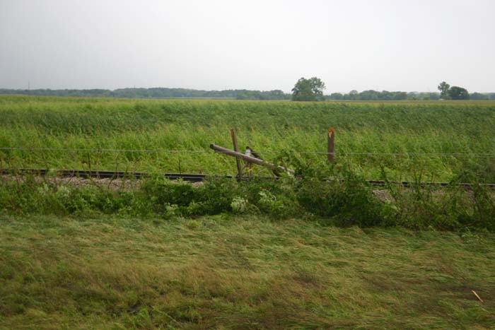
Note also the flattened vegitation in this picture - this was quite evident in the fields and ditches along the highway. By now there were ESDA, fire, power company, and other responders converging on the area. I wanted to be sure they knew about the poles across the tracks before a train came along, so I doubled back to an ESDA person I had noticed on the shoulder of the southbound lanes and told him about the poles down across the tracks. While I was stopped, I noticed another one of the many metal-post signs that were blown down:
Notice that, although I am facing the same direction as when I took the previous picture, the sign is blown over in the opposite direction from the way the utility poles in the previous picture were blown - powerful evidence of the effect of the rotating winds in the tornado.
By now, having stopped 3 times to assist in some way, I was well behind the storm. Frankly, from where it was, I doubt I could have seen anything more anyway, due to the rain wrapping around the back of the mesocyclone. Even had I not stopped, the storm would have been to my ENE, a direction in which I could have likely seen very little. Nonetheless, I did try to catch up to the storm, and could generally see where the mesocyclone was. It appears to have produced two additional tornadoes, one in Loami (though I suppose this could have been a continuation of the same one), which is about midway between Manchester and Springfield, and another in Rochester, to the southeast of Springfield. Although I was in clear view of the storm when both of these occurred and could tell the likely part of the storm where they would have been, I could not see them due to low clouds and rain wrapping around and blocking any possible view of them.
I followed the storms east into the southern part of Springfield, near the UIS campus. Couldn't go any further due to the lake unless I got back on I-72, which would have taken me into the core, which seemed pointless. I did cut east off I-55 at Farmersville for a ways to try to catch up with a new tail-end storm moving over Taylorville, but that proved pointless, too, and the storms were looking like they had a lot less tornado potential by now. So I called it a chase and started home around 4:30.
As described below in the damage survey from the Lincoln NWS, the tornado I observed was the first of 3 long-track tornadoes in central Illinois, two from the supercell I interecepted. The damage surveys are linked below, after the radar image links; here is a list of preliminary local storm reports:
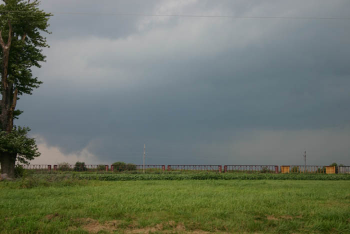
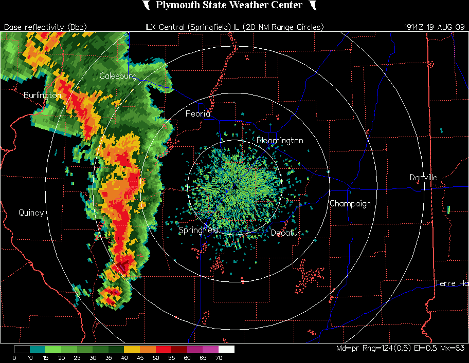
Also, here are a couple radar images. The first is a reflectivity image from 2:14 p.m., just before the tornado began. Note the intense activity near the Greene-Scott County line (the heaviest activity on the radar, near the south end of the solid line of storms), southwest of Springfield:
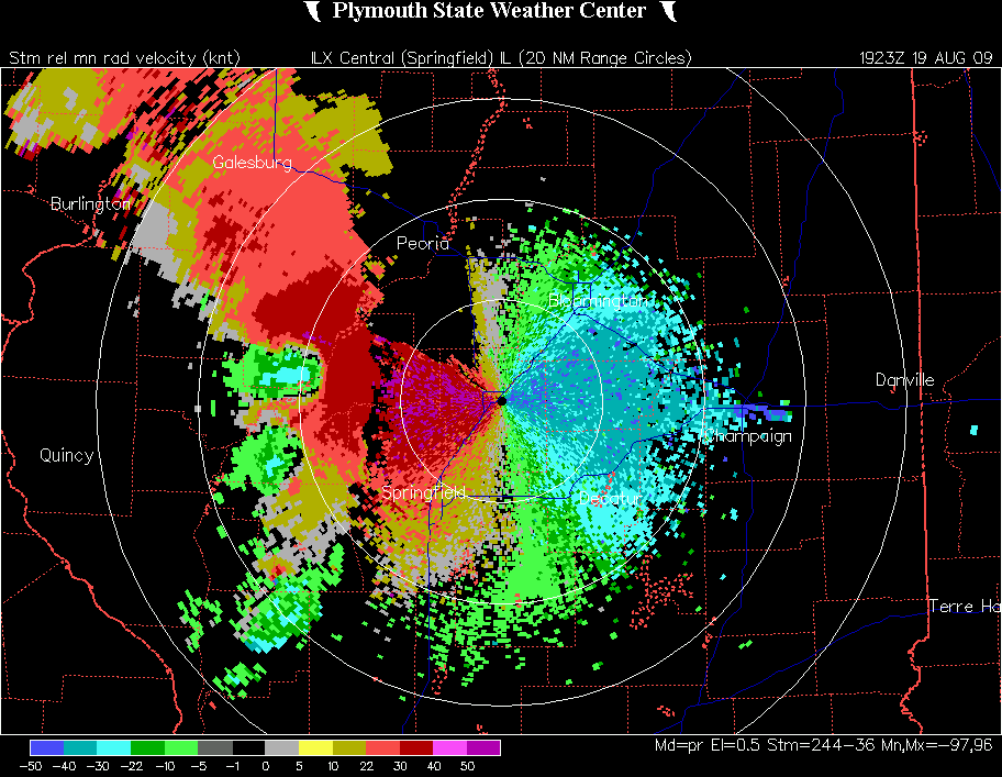
The next image is a velocity image from 2:23 p.m. showing the rotation, around or very shortly after the time that the tornado caused damage in Manchester. Note the bright red juxtaposed with the blues and greens, indicating winds from opposite directions, as occurs with tornadoes.
Storm-relative Velocity Image, 2:23 p.m.
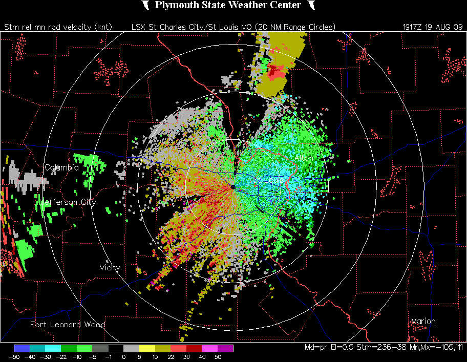
While both of the above images are from the Lincoln, IL radar, the rotation in this tornado also showed up nicely on the St. Louis radar, as can be seen in this velocity image from 2:17, the time when I was watching the tornado:
Storm-relative velocity image, 2:17 p.m.
National Weather Service damage surveys:
1. A survey by the St. Louis NWS office of the part of the damage path in Greene County indicated that the tornado began near Highway 106 just north of Barrow, and continued for about a mile until the tornado crossed into Scott County. The Greene County part of the damage path was rated EF0, and the tornado damaged only trees in Greene County. The survey can be seen here
2. A damage survey from the Lincoln NWS shows that the tornado strengthened into a high-end EF1 tornado with maximum wind estimated at 110 mph after it crossed into their area of responsiblity. All told, the tornado had a path length of 18 miles in 3 counties (Greene, Scott, and Morgan) and a maximum path width of 250 yards. This damage survey for this and the two other long-track tornadoes in central IL (the second of which was from the same storm as the one I observed) can be seen here. Additional information on the August 19 storms and tornadoes can be seen on the Lincoln National Weather Service Web pages here.
Total chase distance: 212 miles.
This page last updated August 21, 2009.