

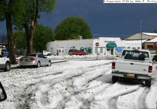

Meanwhile, another low pressure area cut off from the jet stream drifted slowly from northern Mexico into the area along the NM-AZ stateline. At the same time, a pattern in some ways like the late-summer western monsoon developed, with moisture flowing into the Four Corners area from both the Gulf of Mexico and the Pacific Ocean/Gulf of California. This resulted in widespread rain and thunderstorms across AZ, NM, CO, and southeastern UT before and during the Memorial Day weekend. Usually, NM and nearlby areas are dry, windy, and dusty this time of year - but not this year, as this "mini-monsoon" set up around the middle of May and has persisted through the Memorial Day weekend, with potential for it to continue, in a somewhat abated form, through at least most of the remainder of May. Showers and thunderstorms occurred across New Mexico during much of the week before Memorial Day weekend, and continued throughout the weekend in much of the state. We arrived in Santa Fe on Tuesday, May 19, and that evening saw pictures on TV of the spectacular lightning that occurred over Albuquerque the night before. By Thursday, showers and thunderstorms were occurring over much of NM, as the low pressure area crossed from Mexico into extreme southeast AZ, and also began to interact somewhat with a weak disturbance in southern Colorado and a back-door cold front that pushed into northeast NM before stalling out. Around Santa Fe, the atmosphere had not fully moistened up, and the convection, though locally strong, was mostly high-based. I went out and got a few pictures of this activity both southeast and just north of the Santa Fe area. By Saturday, as the low pressure area moved northward along the AZ-NM state line, dewpoints around Albuquerque and Santa Fe had risen to around 50, quite high for New Mexico this time of year. Strong thunderstorms developed near the northwest fringe of the Albuquerque area. These storms produced heavy rain, gusty winds, and probably some small hail in spots. They also treated me to a brief, ropy funnel cloud near the Santo Domingo Pueblo. On Sunday and Memorial Day, the low pressure area continued moving north, crossing into CO and eventually NE, where it merged with a cold front pushing southeast across the northern plains. It continued to influence the weather in northern NM, as afternoon and evening thrunderstorms broke out around Santa Fe both days. Sunday evening, I was able to photograph some of the lightning that occurred in the Santa Fe area. On Tuesday evening, the day after Memorial Day, moisture had dropped off a little bit again, but an approaching cold front triggered another round of higher-based convection. Nothing severe, but at sunset, the storms were among the most photogenic I've seen this year. And then finally on May 27 near Las Vegas, NM, this weather pattern saved its most spectacular show for last - a massive hailstorm that dumped 4 inches or more of up to penny-sized hail over a rather large area around Las Vegas.
One way this pattern differed from the normal late-summer monsoon is that it was much cooler. The high temperature in Santa Fe failed to reach 70 degrees a couple days during the Memorial Day weekend, and during this period I noticed a couple times that the highest mountains above 12,000 feet, such as Santa Fe Baldy, were covered with fresh snow (or perhaps in some cases hail, but they were white at the top, in contrast to having just a few patches of snow when we arrived).
I have put together Web pages on the following weather events I observed around and during the Memorial Day weekend:
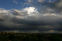
May 21 - High-based convection.
May 23 - Strong storms and a brief, ropy funnel cloud near the Santo Domingo Pueblo.
May 24 - A spectacular evening lightning display over Santa Fe.
May 26 - High-based storms, illuminated by the setting sun.
May 27 - Massive accumulation of hail in Las Vegas, NM.
Return to 2009 Storm Observation page