Severe-warned Storm West of Santa Fe
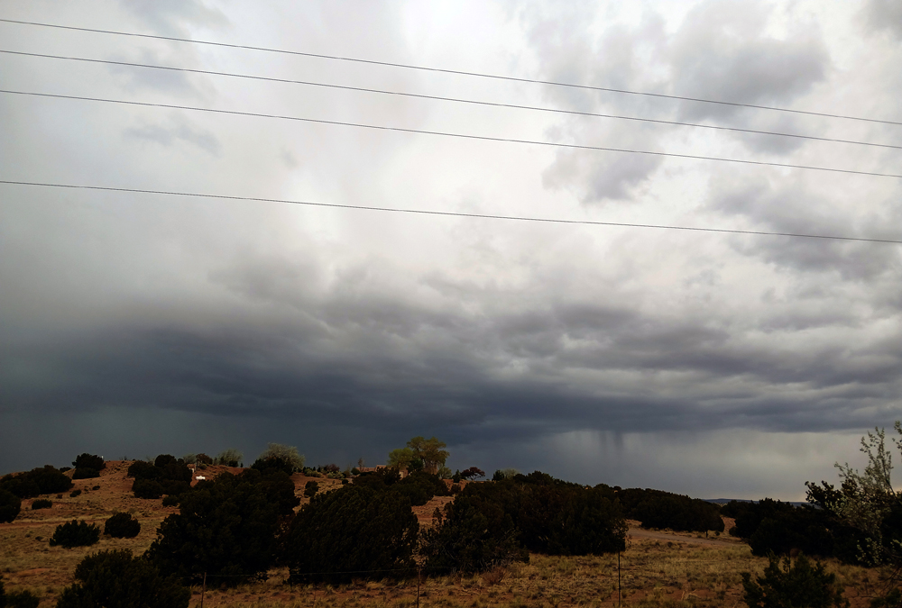
I headed around the north end of town on NM 599, the Santa Fe bypass route, to approach the storm. I debated whether to try to intercept the storm by going NW on Caja del Rio Road or by getting on I-40 and trying to interecept it around La Cienega or La Bajada. I chose the latter option because the storm was pretty far west, and moving to the NNW. Although that let me get a good view of the storm, the other option probably would have been better, as the storm backbuilt to the east making its effective motion at the time more like due north than NNW. And it was moving fast, so the more northerly route would have been better in hindsight. The storm was high-based but obviously strong, and at times put down quite a bit of CG lightning as well as a lot of flashes in the clouds. While I was watching it, it got a second SVR warniong, which included Bandolier and the Los Alamos area. And the inflow was very intense from the southeast as I watched the storm. Here is a picture of the storm, looking north from the La Cienega exit at 2:31 p.m.
But before long, with its fast movement, the storm was getting away from me, so I headed back northeast on route 599. As I was on the ramp to I-25 to get back to 599, I had a clear view of the storm, so I pulled to the side and took a little video - and got these two flashes of CG lightning:
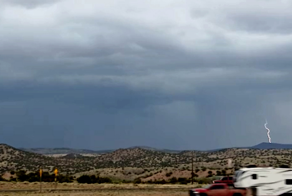
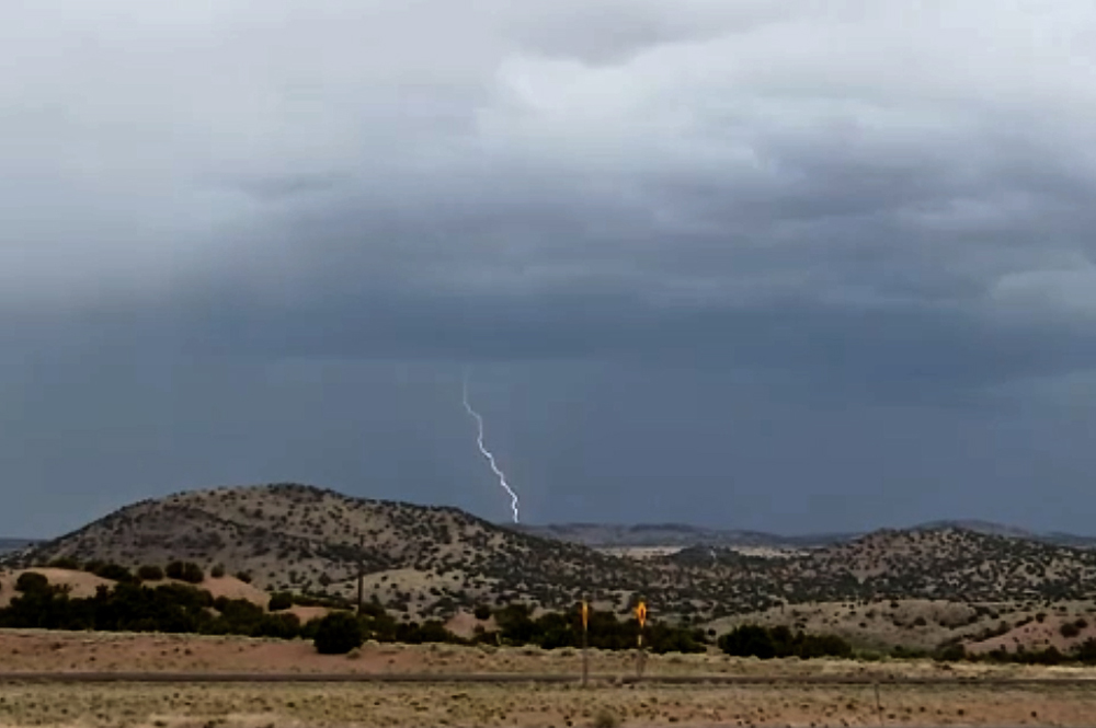
In the first picture (both are video captuers), you can see a light area just under the base of the cloud, to the left of the lightning. This could have been a cloud lowering, but I think more likely it was frozen precipitation - some combination of hail, graupel, and/or snow - coming out of the base of the cloud, and appearing lighter in color than the precipitation in the background. It was a few minutes after the time of these pictures when the storm got its second SVR warning, which included the Los Alamos and Bandolier areas.
Returning to route 599, I initially thought I might try the Caja del Rio option to get closer to the storm, but did not because 1) the storm was moving away from me too fast, and 2) new storms were now forming south of the Santa Fe range of the Sangre de Cristo Mountains, which I figured could produce thundersnow in the mountains. So I decided to transition to that phase of the chase. Despite the two SVR warnings, I did not see any reports of severe weather with the storm, although there may have been some. There wre reports of half-inch hail and wind gusts of 42 and 46 mph. Both wind gusts were near the location where I was watching the storm and I think may have been from the same inflow winds that I experienced. Those speeds seemed in line with what I obsered.
Thundersnow for the Second Day in a Row in the Sangre de Cristo Mountains
I headed back to Santa Fe via route 599 and then up Hyde Park Road/Ski Basin Road to the ski area. It was evident during this time that new storms were forming and would soon move over the Santa Fe Range of the Sangre de Cristo Mountains, and soon they did. I encountered some at times heavy bursts of mixed preciptitation, as this storm, though moving toward the northwest like the storm that gave me thundersnow the previous day, was following a track that was a bit to the west of the previous day's storm, so nearly the entire route up to the ski area received precipitation as opposed to only the upper part, at least initially, the previous day. Another difference was that the level I had to reach in order to get all snow was higher. Although I encountered mixed precipitation with lightning and thunder (a time or two loud enough to hear even in the closed car), it stayed mixed even past the Big Teseque campground and picnic area, where the previous day it had been all frozen precipitation. However, by the time I reached the ski area, I had finally gotten rid of the rain. There, it was all graupel (snow pellets) and ordinary snow, with the predominant type going back and forth between those two. The thunder was less frequent than it had been the previous day (and also less frequent than it had been lower down along the way up there), but it was there - so I had the rare experience of catching thundersnow on two consecutive days! Here is a short video showing the precipitation and a couple rumbles of thunder:
With the track of the storm slightly more to the west than it had been the previous day, it was evident that the heaviest snow was falling west of the ski area, and the thunder was coming from that direction. As it continued to move off to the northwest, I called it a chase, as I wanted to watch the St. Louis Blues hockey playoff game that began at 5 p.m. Mountain Time.
Hail and Snow at the same time - Rain, Graupel, Lightning, and Thunder, too
More storms rolled in during the first period of the hockey game, including a heavy one that produced heavy rain mixed first with hail and then later with some wet snow and/or graupel (snow pellets) during the first intermission. The hail and snow/graupel did not occur at the same time, although they did come from the same storm. And there was also a brief power outage that disrupted the cable TV, but it came back in time for the second period of the game. I did get a little video of the storm between periods, but a better show was to come later. The storms continued intermittently through the rest of the game, even though it went to 2 overtimes, and the storms continued well after the game was over. The first overtime did get interruoted by another brief power outage from a close lightning strike. Basically the storms were forming to the south of Santa Fe near I-40 and training, i.e. tracking repeatedly over the same areas, including eventually Santa Fe. Some of the storms were severe and produced hail of 1 to 1.25 inches in diameter around Edgewood, Chilili, and Sedillo. They would later produce some hail in Santa Fe, too, but not that large.
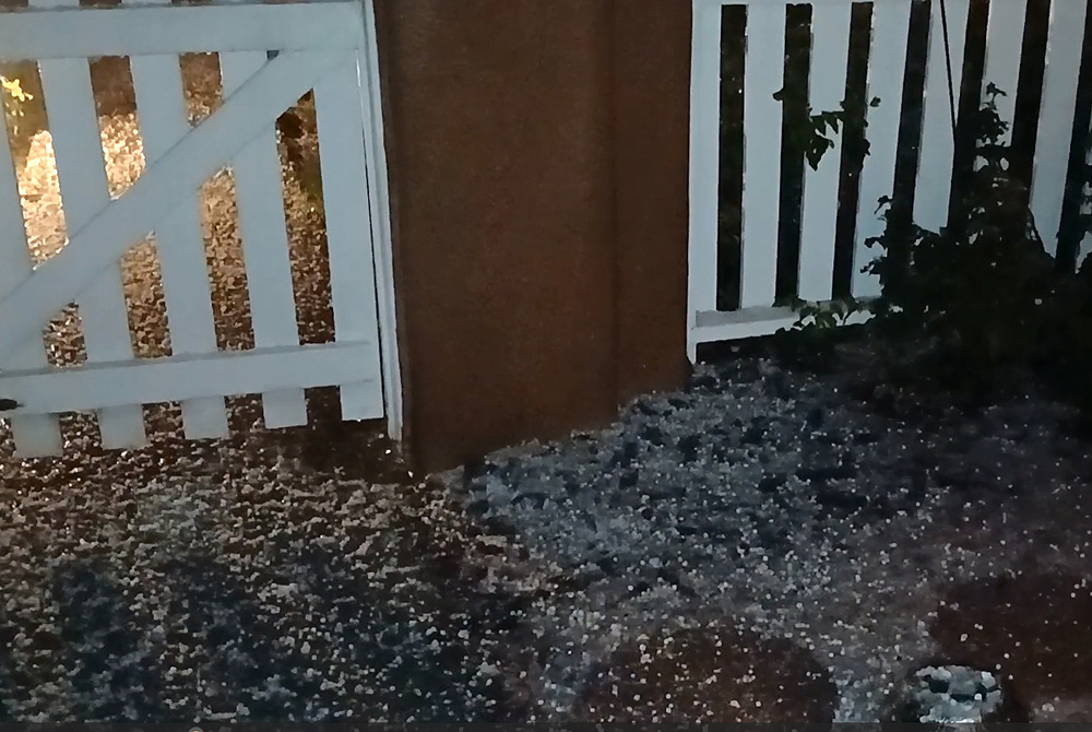
Perhaps the best got saved for last, though, as another storm from the aforementioned cluster of storms that originated around the Edgewood/Golden/Moriarty area and got SVR warnings (which, as noted above, verified) moved north into Santa Fe after 10:30 p.m. It produced the rare combination of hail and snow at the same time, along with graupel (snow pellets), rain, and a lot of thunder and lightning, with a few strikes that were quite close. As it moved in, I grabbed my phone, went to the front porch, and got video. The edited video appears below. There is a short period where there is quite a bit of hail, all small around 1/4 inch in diameter. But even then, the majority of the precipitation was a mix of wet snowflakes, graupel (snow pellets), and rain. I say that because I reached my arm out from under the roof during the hail and what then hit my arm was soft - graupel and wet snow, not hail. But afterwards, I did inspect what was on the ground and there were some hard, icy hailstones. So there definitely was some hail, but it was mixed with the winter precipitation, graupel and wet snowflakes, along with some rain. Toward the end of the video I reached out into the precipitation again (little or no hail by then), and you can see graupel and wet snow landing on my arm. I have seen snow and hail at the same time on rare occasions before (there honestly was a time when I questioned whether it was even possible), but you can count the number of times on the finger of one hand. So what I caught with this storm was definitely a rarity.
Here is video of the snow, hail, graupel, and rain in the thunderstorm that came through around 10:45 p.m.:
Here is a picture of the accumulated frozen precipitation, captured from the video. There is a slushy accumulation of snow and graupel on the ground except for not much on the sidewalk and the round pavers, where it mostly melted on contact, along with hailstones in that accumulated both on and off the sidewalk and pavers. And as I said, I did find hard, icy hailstones on the ground, very different in texture from the snow and graupel.
At some point during the evening, I looked at the Ski Santa Fe webcam to see if I could see snow and lightning. I did - when I first looked at it, lightning was very frequent with snow coming down. I posted the link on the Weather and Science Facebook group, with a note that the link was time-sensitive. The frequency of lightning there varied, but it continued for at least an hour, including one brilliant flash that immediately but temporarily took the webcam off line. So it was a very impressive episode of thundersnow up there, though getting there and back in the storm at night would have been extremely difficult. Total precipitation for the day in Santa Fe proper ranged from around 1.3 to 2.5 inches, with higher amounts in some nearby areas. And as it turns out, there was still more to come, but you will have to go to my chase report for May 5 to read about that.
Return to 2024-25 Winter Weather Observation Page
Return to 2025 Severe Weather Observation Page