Being in Springfield, CO, I was not far north of the OK Panhandle, and figured there was a good chance I would end up heading there. But I wanted to hang around for a while to see if any isolated cells would spring up ahead of it in southeastern CO. Which I did, but keeping my southeastward options open, I never went farther west on 160 than Pritchett, CO, 14 miles west of Springfield. By early afternoon, the expected squall line had formed along a line from around Limon to between Pueblo and Walsenburg, then down I-25 to south of Raton, NM. It started getting a few warnings, but I was interested in supercells ahead of the line, not the line itself at this point, though I knew that no matter what I did I would eventually get overrun by it. This line did produce a tornado northeast of Walsenburg around 1:50 p.m., severe hail and some severe gusts in far northern NM (south of the severe thunderstorm watch that was issued for SE Colorado), and a bit later severe wind from Springfield CO, and then eastward and ESE-ward for hundreds of miles as the day and evening went on. By around 12:30 it did not look to me like any isolated supercells were going to go up in CO before being overtaken by the squall line, so I went back to Springfield, got some take-out lunch, and headed south for the OK Panhandle. In hindsight, I should have done this sooner and at a less leisurely pace, because I ended up rather out of position on what turned out to be the storm of the day, too far west for the great views of it that others got, although at least I did see it.
Storm 1: Beaver, OK Supercell
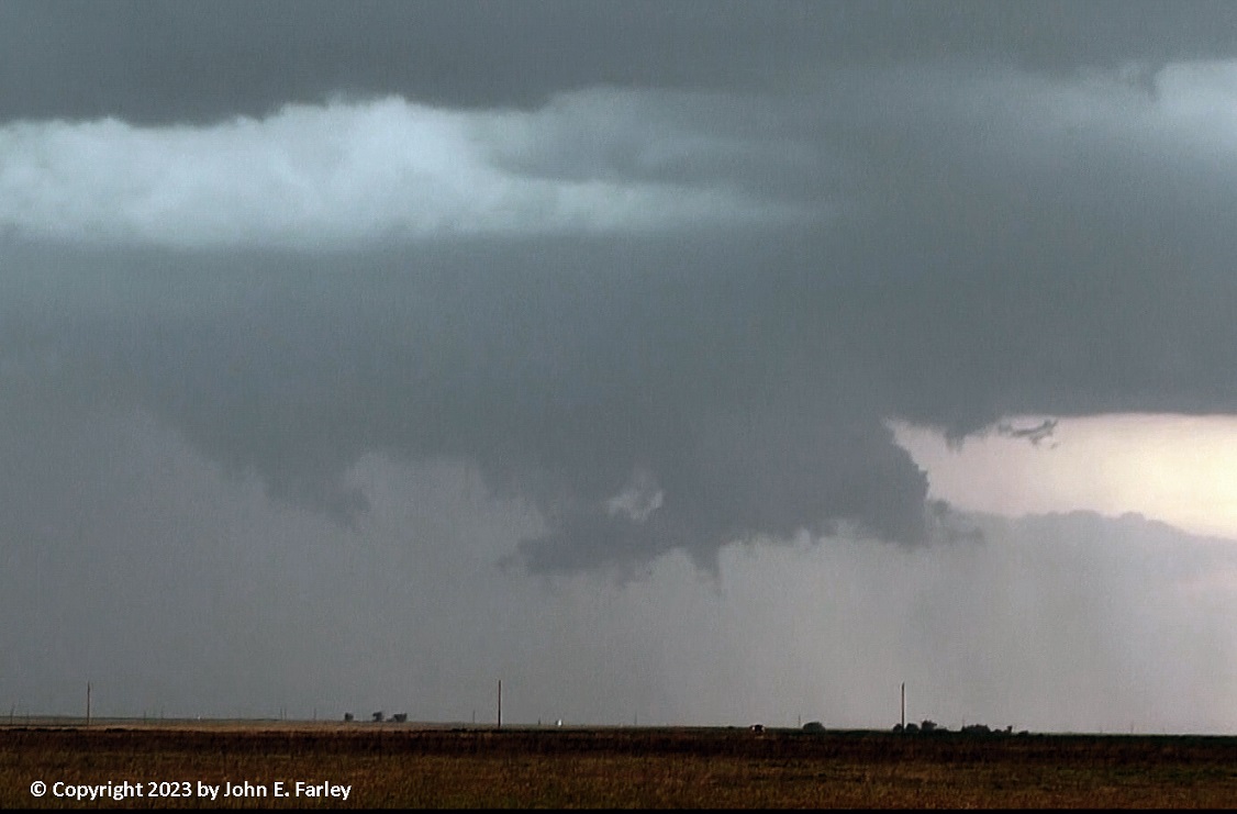
By 2:30, the isolated supercells predicted by some of the CAMs were indeed going up over the OK Panhandle. Initially, one east of Guymon (which became the storm of the day) and one west of there. I blasted east, taking back roads eastward to the north of Guymon, trying to catch up with the eastern storm. As I neared US 54 I had difficulty finding a place to get on it, wasting a bit of valuable time before I did. From there, I went just a little bit NE before cutting east again on Road Q, which unlike the road I had been on before, is paved. By now, around 5:20 p.m., the eastern storm was TOR-warned, and a new storm going up directly overhead started dropping big raindrops and a little hail. I eventually managed to get ahead of this storm, which by that time had become a supercell and was SVR-warned. I was still trying to get to the eastern storm (hereinafter, the Beaver supercell) as it got another TOR warning just before 6 p.m. It intermittently produced large wall clouds, which at times I could see were rotating, even though I was at least 15 miles from the storm. I did not stop to get any pictures or video, because I was still trying to catch up. By the time this storm got its third TOR warning, around 6:20, I had arrived at the point where Road Q jogs north, just before the Texas County/Beaver County line. This TOR warning said there was a confirmed tornado southwest of Beaver, but that turned out not to be the case. At that point, I was between the two supercells, with the Beaver storm maybe 15 miles east of my location and the one to my west (hereinafter, the Hooker-Turpin supercell) considerably closer, and moving in my general direction. I was going back and forth between photographing/videoing these two storms. The TOR-warned Beaver storm would go from no lowering to huge wall clouds, sometimes with rotation and also some at-least brief funnel clouds, and then back to no lowering. It did this at least 3 times that I could see. Athough I was too far away (and looking through some rain) to get the great shots some chasers who were closer and in better position got of this wall cloud, at least I did see it and get some pictures of it:
Storm 2: Hooker to Turpin, OK Supercell
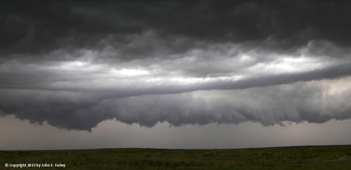
Since from where I was located, I would have to go north in order to get any farther east, I opted not to do so - it would have taken me into the core of the Hooker-Turpin supercell, which had already produced 2-inch hail in Hooker. I did not want to drive into anything like that! So from there on, my attention was on this storm, whose core was now to my north, but the updraft and mesocyclone were to my west. My location at this time, and also for my later observation of the derecho, was where Road Q turns north, just west of the county line mentioned above and southwest of Turpin, OK. The meso was moving toward me, with quite a bit of CG lightning in the vault area and the core to its north and northeast:
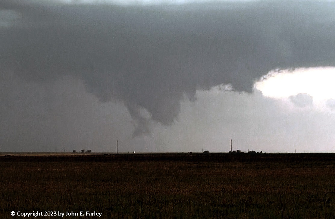
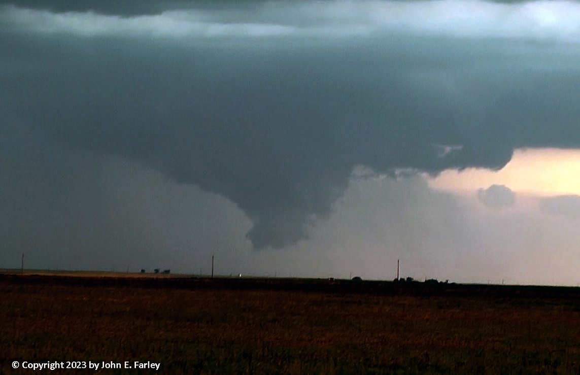
Although the rotation in this storm was not as dramatic as some I have seen from chaser videos of the Beaver storm, this storm, too, did display pronounced cloud-base rotation. And unlike with the Beaver storm to my east, I was in a perfect position to get video of the rotation in this storm:
As you can see in this video, the rotation moved almost directly over me. I was not extremely worried about this, because there was no real pronounced lowering and no evidence of any ground circulation. Nonetheless, once it was overhead I darted temporarily to the west to be clear of it, then once it had passed, returned to my previous spot to watch it move away from me. However, as it continued to the east, it offered nothing more as dramatic as the rotation in the video above, and now it was time to get ready for the passage of the rapidly-approaching squall line.
Storm 3: Squall Line/Derecho
While the supercells had been drifting rather slowly to the east (eventually, ESE in the case of the Beaver storm), the squall line, which as noted had begun far to the west near I-25, was racing eastward much faster at 40-50 mph. And I could now see that it was soon going to overrun my position. Here is how it looked as it approached:
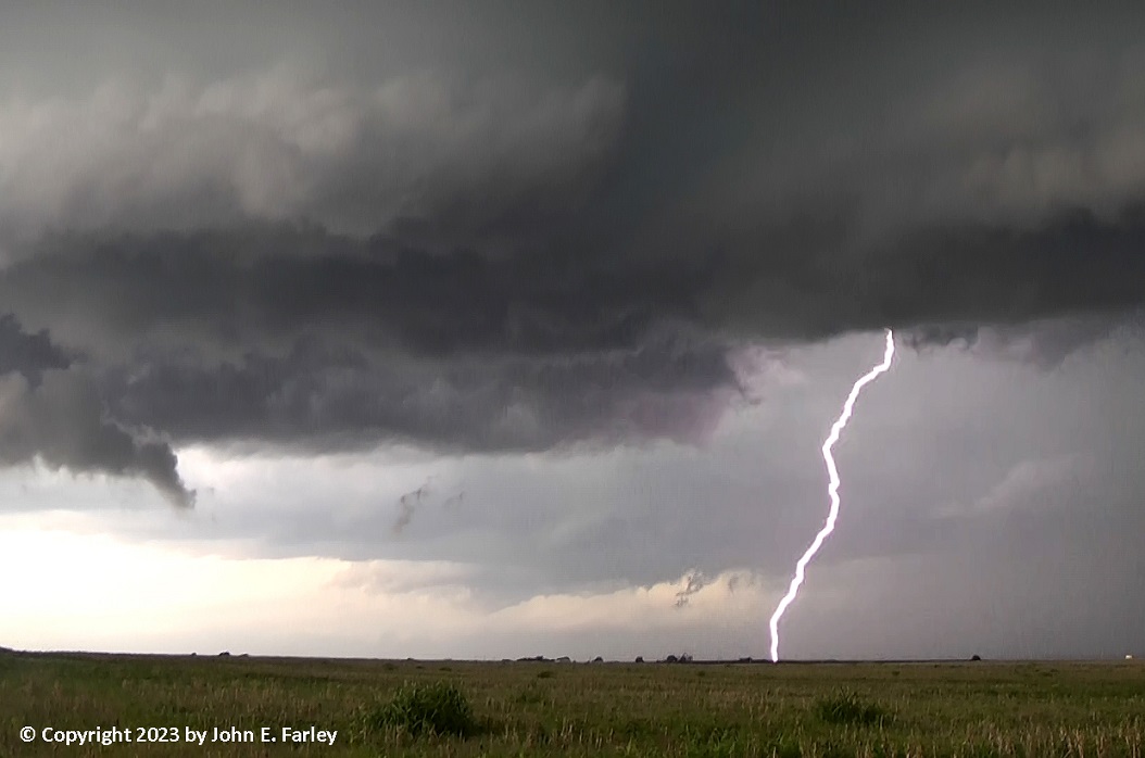
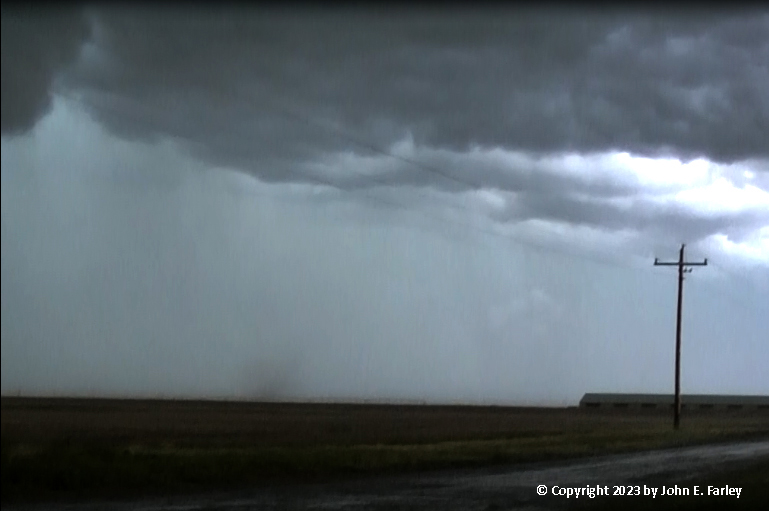
I knew there was no getting away from it, so I decided to stay put, position the car so it would be looking away from the northwesterly wind and not be downwind of any poles or wires that might come down. When it arrived, it produced a blast of intense wind, then a wind-driven rain that quickly mixed with up to 1-inch hail. When I looked at the video below, I also realized I had captured a likely gustnado just after the rain began. It must have been pretty strong to kick up dust like that when the rain had already wetted the ground. The gustnado passed to my north moving SE with the outflow wind. It was already going on when it entered my video, so I do not know how much earlier it began, though I saw no evidence of it before I turned the car away from the wind. The hail continued for 5 or 10 minutes, mostly dime to penny sized, but at times with quarter-sized stones mixed in. I was surprised to see that much hail, and that big, in a squall line. But I think what happened was that, as the line approached and passed over, a mesovortex or perhaps a supercell embedded in the line developed. There are hints of that in the first part of the video, and radar reflectivity ramped up quite a bit as the line passed over me. And perhaps most tellingly, the AMA NWS issued a tornado warning for the line shortly after it passed my location (actually, while I was still in the hail), based on detecting strong rotation about 10 miles to my east. Heavy rain and strong wind continued for quite a while after the hail moved on, but I knew this was the last of the storms so I started west back to Guymon to get a room for the night. However, I noticed there was a tremendous about of lightning to my south and southeast, so I stopped to get a little video of that. The storm cooperated by promptly throwing down a CG bolt about 2 miles to my south.
This storm ended up meeting the criteria of a derecho, as it produced severe wind (along with hail and a handful of tornadoes) all the way from far northern NM and southeast CO through the length of the OK Panhandle and on across the rest of OK, producing 100 mph wind and severe damage in the Tulsa area. When the line caught up to the Beaver supercell, that cell became the apex of the bow echo that surged east, eventually into and beyond the Tulsa area. From my later review of radar, the absorption of that cell also seemed to be associated with a tornado that occurred near Laverne, OK. North of the apex northeast of Tulsa, there were at least 3 tornadoes. When tornadoes occur with bow echoes, it is often near or to the north of the apex. The derecho continued on across AR and apparenty even into TN, as there were a number of severe reports around Memphis. So here is the video of my little piece of this derecho, featuring the approach of the storm, the high wind, the gustnado, the hail and the lightning:
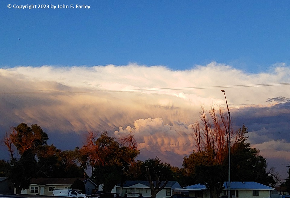
Later, after I had gotten a room for the night in Guymon, the storm was being beautifully illuminated by the setting sun:
Chase mileage for the day:226 miles
Chase mileage for this entire chase trip: 1065 miles