
I would not consider the day a bust, as I saw several severe storms, but it was not what I was hoping for. Initiation was earlier than I had expected or hoped, and due to this and the strong forcing, the storms went linear much more quickly than I had hoped. Basically I intercepted the storms a little before 2 p.m. near Memphis, MO, then worked east along US 136 to just west of Macomb, IL, moving ahead to catch each new line segment as they surged north at 50-55 mph - seemed like new segments would form just SE of the existing ones and race north. Then I went south and east on the backroads from there to Industry, then south to Rushville, where I ended around 7 p.m.
Detail:
This was the most likely setup for severe weather so far this year in Illinois and nearby areas, but certainly also one with many downsides from a storm observation standpoint. A negatively-tilted trough would race through the Midwest today, after the system had been stalled to the west for several days since producing a big outbreak on the high plains on the 28th. A deepening surface low would race from KS through western IA up into MN, with an occluded front SE to a triple point that would race NE through central IA. The warm front would surge north across eastern IA, WI, and northeastern IL, while the cold front (a pacific one, almost more like a dryline, with only modest temperature difference across the front) would cross IA and MO into IL and southern WI, with a negative tilt orientation as well. There would be some directional shear with strong winds at all levels, and the upper winds both strong and divergent. But the rapid movement of the front would force the storms into lines rather quickly despite the wind shear, and the storms would be racing north or NNE at upwards of 50 mph. Still, I, along with many other storm chasers, thought there would be some potential for tornadoes, especially in northern MO, southern IA, and parts of western IL, where the frontal boundary would be more NW-SE oriented, so the wind would not be as parallel to the front as farther south. For more discussion of this setup by me and by many others, see the Storm Track forecast thread.
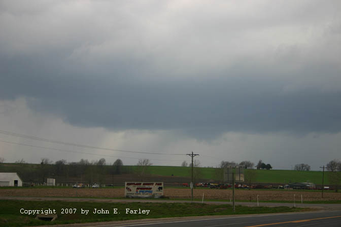
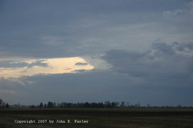
I was out the door at 9:40 a.m., with a target of somewhere around Kirksville, MO - farther northwest might be better, but I figured that was about as far as I could realistically get. After a data stop in Hannibal a little before noon alerted me to the fact that the storms had formed earlier than I had expected, and many were already becoming linear, I continued north on route 61 to route 136, and blasted west on 136, reaching the area of the storms just west of Memphis, MO a little before 2 p.m. The storms were already very linear, but I did notice a little break in the line to my southwest, as shown in this picture. There seemed to be a stronger updraft in this area, with a slight lowering and what looked like some hail shafts around it, although the storm had no warnings. However, shortly later, it dropped 1-inch hail on Lancaster, MO (about 9 miles west and a couple north of my location) along with estimated 60 mph winds, and became SVR-warned as it raced north into Iowa. I decided to let it go and try to position myself for another storm to my south that was SVR warned, hoping there might be more of a break or irregularity in the line there than what I was seeing here.
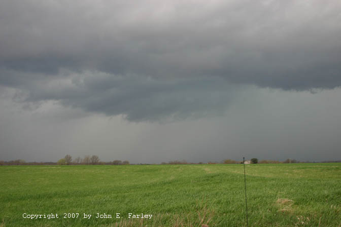
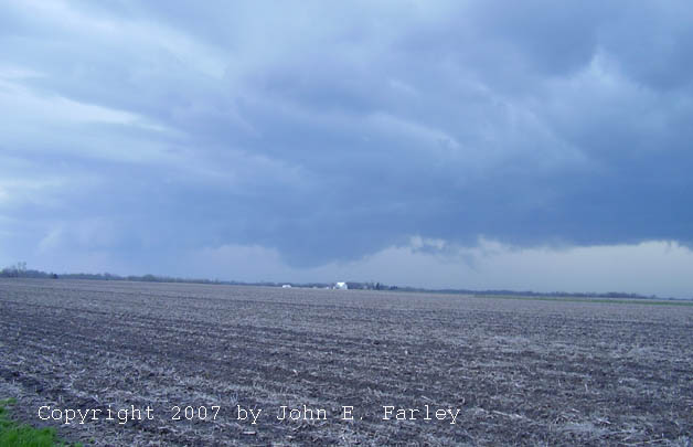
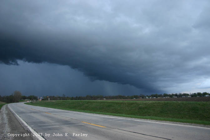
I backtracked to around Granger, and turned south a little to watch the storm approach. At this time, a small lowering that had a bit of a wall cloud look to it formed to my west along the line, but it did not persist for long at all. There were other lowerings along the gust front, too, but none rotating that I could see, and none very persistent - they just seemed to be lowered areas on the gust front. Moreover, the warning was eventually dropped on the storm to my south (which was racing towards me at 50-55 mph, but still a fair distance down the line to my south or SSW). So, I decided to move a bit farther east, but as I was about to turn back on to 136, I noticed this lowering to my northwest. I watched it for a couple minutes; I think it, too, was just a lowered area in the shelf cloud but in any case it quickly disappeared in the rain. So, I headed east on 136 back toward Kahoka, and soon heard a new warning for a cell to my SSW along the line. I thought I could intercept it around Kohoka, but could soon see a new line of precip forming to my SE, and figured that if I did not get east, I would get swallowed up in the heavy precip and see nothing. Originally, I had hoped to get ahead of the storms and watch from a spot in the wide flood plain along 136 between route 61 and the Des Moines River, but it was clear that the rapidly intensifying line segment to my SE was going to overrun me even there, so I decided to cross through Keokuk into IL. As I crossed under the rain band, it intensified rapidly, and the weather radio put out a statement for a line of storms developing from Vinton, IA to Keokuk, with warnings likely soon. I began getting quite a bit of lightning and thunder right behind me as I crossed into Hancock, IL, where I stopped and looked back to see an impressive shelf cloud - but the storms were about to overrun me, so I repositioned a little east of town and photographed the rather impressive shelf cloud:
This formed under the new line segment I had been watching, and I noticed yet more development just to its south - again in an area where it would overrun me as it raced north if I did not reposition to the east. So, I moved to a little east of Carthage, IL, where I got this shot of what looked like the tail end of the storm, just before the line went SVR warned for Henderson Co., the next one to my north, and several others. (Around this time, it did, in fact, produce wind damage in Henderson Co.) There was a lot of rising scud under the updraft that eventually formed into the lowering in the preceding picture, but it never looked very organized. I looked at the map for north options to try to chase this north a little, since it was SVR warned, and found a close one. Looking back to the road, I could see that my north option was nearly across the street from where I had stopped, so I took that as a sign, and blasted north and stayed with the storm for about 5 miles or so, to Fountain Green. It still had a small lowered area under the updraft then, but it was disappearing in the rain, and I was about to be overrun by rain from the next cell south (which would contaminate the updraft in any case, preventing further intensification. So, I decided to break off and reposition east for other storms down the line.
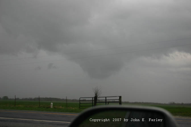
I followed the section roads most of the way toward Macomb before returning to 136 between Macomb and Colchester. There I noticed a very hard updraft going up into the anvil well to my SSW, and I thought that looked like the most intense updraft I had seen all day, so I decided to head south to intercept it ASAP. I figured as long as I went south with the storms blasting north at 50-55 mph, it would not take long. Very soon, around 5:45, I heard the first of two SVR warnings for this storm, the first one being for eastern Adams Co., IL. Within 15 minutes or so I was in Bethel Twp. in the southwest part of Hancock Co., a couple miles SW of Fandon. There I could see the base with some lowerings way off to my SW, but the contrast was poor. Soon, an new SVR warning was issued for this storm for northwestern Schuyler Co, just to my south. This storm was the best-looking one I had seen all day, as it moved toward me through northwestern Schuyler Co, IL:

Later review of radar showed me that this storm started out discrete and merged into the line at the tail end of a line segment, with a distinct break in the line. It had a nice lowered area, as shown above, for a while - possible wall cloud - and was the most electrified storm I saw all day. However, by the time it got close enough for a really good view, it was clearly going outflow dominant, as all the storms were quick to do on this day. In the picture above, which was taken with a 70-300 mm zoom lens, it is clear that the clouds to the left of the lowered area are outflow related - could be RFD gust front from a meso in the lowered area, or could just be all gust front, including the lowered area. Here is a less zoomed picture showing the wider perspective; note there seemed to be another lowered area back in the rain to the left of the more visible lowered area. In any case, as it came toward me, it became more clearly outflow domiant, and it became evident that, like all the other storms I had seen today, it was unlikely to produce any tornadoes. The storm did, however, produce penny-sized hail in extreme eastern Adams County somewhere around the time the pictures above were taken. Another interesting feature of this storm and some of the others on this day is that, even when it was linear and appeared outflow dominant, I was in very strong inflow from the SSE, even when the storms got within a mile or less of my location. In fact, it was some of the strongest inflow I have seen with linear storms - I would estimate up to 40 mph in some locations - had to make a mad dash to recover my cap once, and that was with it on backwards so the bill did not get in the way of the flash on my camera when it wanted to pop up with the darkened sky. Also, when I was in the inflow, the temperature was typically in the upper 60s or around 70, while in the actual storms it was in the lower 60s - and sometimes I observed this difference in distances of under a mile.
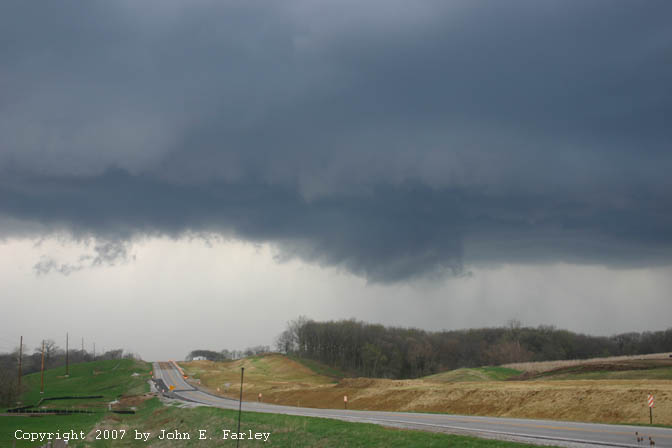
I remained at this position until I was about to be overrun, then headed east to Industry where I turned south on route 51 in hopes of getting in position on the new tail end of the backbuilding line. But west of me all the way to Rushville, it was just linear stuff. Just past Rushville I noticed intense development on the southern end of the line, with more rising scud and new precip shafts quickly appearing. North of that area, the line appeared to be bowing out somewhat, and the weather radio blared out a new warning for McDonough County. This picture was taken looking north from just south of Rushville, showing the bowing segment, a little before 7:00 p.m. I heard the warning a minute or two after I took this picture, and a couple minutes after the warning was issued, a 67 mph gust occurred at Prairie City in McDonough Co., well up the line from my location. Once I left this spot, I figured the chase was pretty much over.
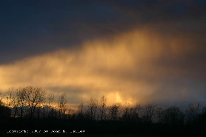
However, I did get some nice sunset pictures when I stopped at Beardstown for dinner, perhaps my best photos of the day. Here is one:

Another sunset shot from Beardstown, IL, showing tail-end updraft illuminated by the setting sun, can be seen here. I then continued on to Jacksonville, and returned home via I-72 and I-55. On 55 around 10-15 miles S. of Springfield, I ran into the heaviest rain I encountered all day from a new line of storms that developed from Springfield down to the Illinois part of the STL metro area, the second line of storms to pass through that area. The first produced a brief rain-wrapped tornado in the city of St. Louis around 5:50 p.m. - the only one confirmed anywhere in MO or, to my knowledge, IL from this storm system.
This was my first chase that included 3 states while in active chase mode. OK, it was only a couple miles in Iowa through Keokuk, but it counts - a new line segment was surging through the west side of Keokuk as I came through, and the shelf cloud pic above was taken shortly later just a little into IL.
Total chase distance: 510 miles.
Radar Images (my approximate location shown by red X):
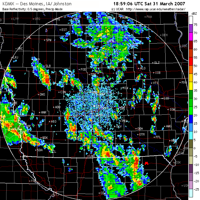
Des Moines Radar, 1:59 pm - I am watching the severe storm near Lancaster, MO
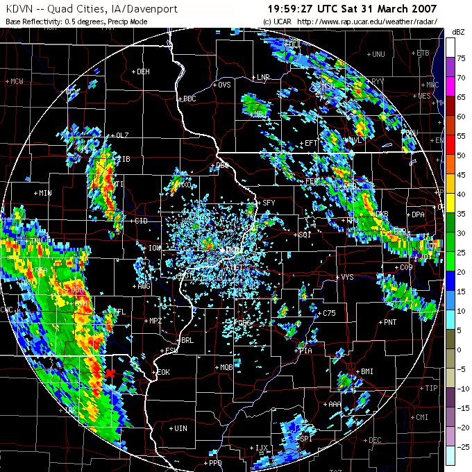
Davenport Radar, 2:59 pm - I am near Granger, MO, watching storm to my west that produced a couple lowerings. The next storm north in Iowa looks nice on radar, but with it racing north, I could never have caught it.
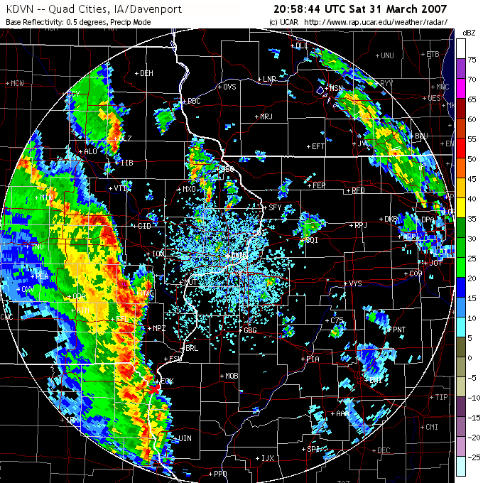
Davenport Radar, 3:58 pm - I am repositioning east as the storms are about to overrun Keokuk. Note the little extensions northeastward from the line - one is to my SE, another to my NW, and another one yet farther north. These were newly developing line segments that soon became the leading edge of the line.
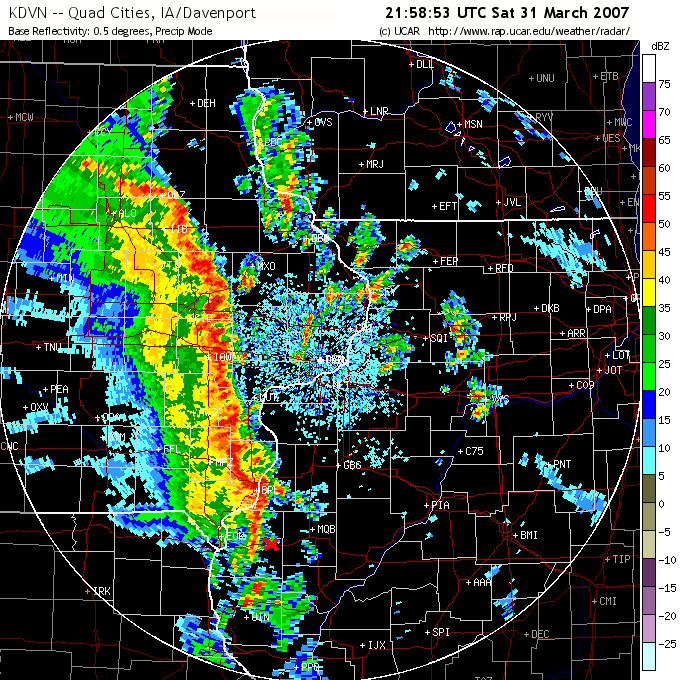
Davenport Radar, 4:48 pm - I am watching tail-end of the line of SVR warned storms from east of Carthage. I wish I had known by then about the discrete cells to my south. At that time, all I could see was the anvil rain. But shortly later, when I pushed east, I noticed the hard updraft tower and blasted south toward the storms.
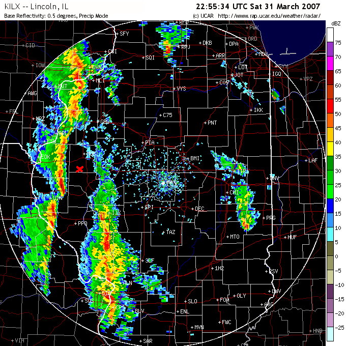
Lincoln, IL Radar, 5:55 pm - I am now in southwestern McDonough County, waiting to intercept the SVR-warned tail-end storm. The storm had a pronounced lowering and was very electrified, but still a little too far away to see really well. It weakened and looked more outflow dominant as it moved through northwestern Schulyer Co. toward my location.
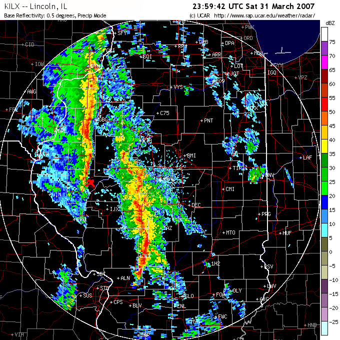
Lincoln Radar, 6:59 pm - I am on the tail end of the line near Rushville, as the line goes SVR warned again and produced wind damage in northeastern McDonough Co.
Local Storm Reports:
Reports for the storms I was on