
The basic setup was that a strong cold front was moving into very unstable air across southern Illinois. Initially the thinking was that leftover storms from the previous night's convection would fade out and be replaced by a new batch, but what actually happened was that the storms from overnight just kept going and reintensified in the warmth of the day and the very unstable air. In addition to the instability, there was strong and divergent upper flow, speed shear, and some, but not a lot, of directional shear - forecast was for mostly SSW winds at the surface and SW to WSW up higher.
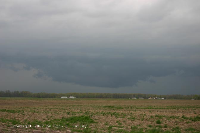
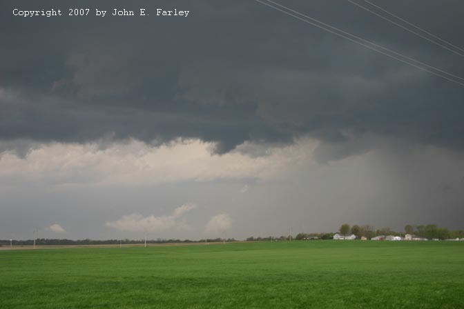
In summary, I got on 3 severe storms this day. The first I watched from between Troy and Marine, IL as it passed just to my northwest. Basically, I waited at home until the storms were approaching Madison County, then headed out around 11:15 (time approximate) and tried to stay ahead of the storms as the line worked its way SE (though individual cell movement ranged from ENE to ESE). I stopped along IL route 4 between I-70 and Lebanon and watched as this storm formed kind of a wall cloud feature over Edwardsville:
A more zoomed photo can be seen here. Soon after I had left home, this storm had gone SVR warned based on an indication of 60 mph wind and quarter-size hail near Wood River. Later updates tracked the storm as it moved through the Hamel and Alhambra areas. Thankfully, the lowering depicted above never came close to anything tornadic (thankfully, since I live there!) though it did drop 1-inch hail in the Hamel area and additional hail in other areas to the east and ENE of there. I followed the storm east as far as Carlyle, and it looked quite mean at times but gradually more outflow-dominant. It was getting north and east of me as I went, and Carlyle Lake precluded my chasing it any further, though it remained SVR warned. In fact, at least 3 SVR warnings were issued on this storm east to Carlyle Lake and beyond. In addition to the storm getting away from me, I noticed that a second storm had formed down the line to the SW, and it was looking better, so I headed south on 127 from Carlyle in hopes of intercepting this southern storm. Around 12:40, I heard a SVR warning for this storm for counties to my west, and later also for Clinton Co, as I crossed south from that county into northern Washington Co.
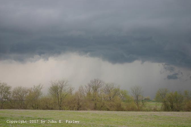
As I headed south on 127, I could see that this storm had a nice rain-free base (RFB). When I got to I-64, I decided that, since it was time for lunch, I would hit a drive-through then wait there for the storm. It was moving pretty fast, and I was not sure I could get to the next exit ahead of it, anyway. While I was in the drive-through line, the storm promptly went TOR warned for Washington Co., IL - where I was. This was around 1:15 p.m., with the warning valid until 2:00 p.m. This storm never really looked all that impressive, though. Looking to the SW, I could see a sort of scuddy lowering under the updraft base with what looked like an attempt at an inflow band. As the storm moved in I saw what looked liked it may have been a partly rain-wrapped meso as I followed the storm from Nashville to the ESE for 10 miles or so. You can see that feature, the rightward of the two lowerings, in this picture. Shortly after that picture was taken, I got in some intense outflow (RFD?) and saw what I thought may have been a gustnado off to my north, but I was not sure given the distance. After looking at and enhancing one of my photos, I am pretty sure, though, that it was a low scud cloud in poor contrast, which I could not see the bottom of because of a row of trees. I followed the storm as it moved ESE for 10 or 15 miles on back roads southeast of Nashville, IL, but it seemed to look less and less intense - though it did get a new SVR warning for counties to my northeast around 1:30. Despite the TOR warning, this storm never looked particularly close to producing a tornado, at least from my vantage point.
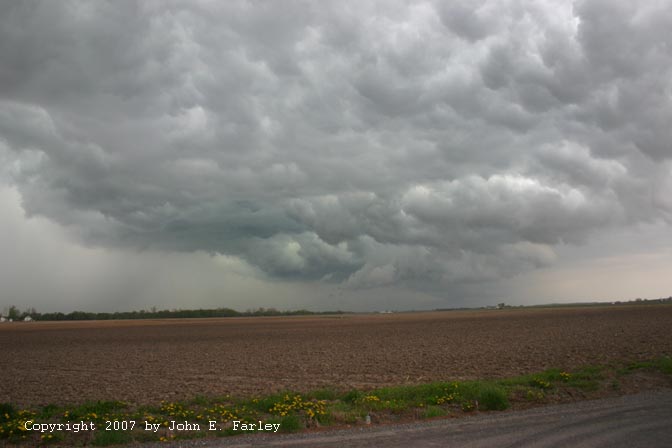
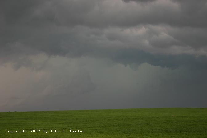
The third storm I got on was in Pinckneyville shortly after 3 p.m. I had continued to work my way down the line to try to intercept new storms developing to the southwest. At 1:30 and 1:50, new SVR warnings were issued for counties to my west. The line began to look very nasty to my northwest, west of Nashville. Not surprisingly, around 2:00, a new SVR warning was issued for Washington Co. But the line, which had been a little bit broken at first, had now filled in to a pretty much solid line that was backbuilding faster than I could get around it. I reached Pinckneyville and turned west toward the storms, to see what I could see. Passing through town, I noticed a closed gas station with a roof over where the pumps had been, and figured that might be a good spot should I need to take cover from hail. I knew by then that to get home I would have to cross the line of storms, and when I got to them west of Pinckneyville, it was looking really nasty, with a dark blue-green color suggestive of hail:

I hung a U and headed back east to Pinckneyville, to get under a roof at the closed gas station I had noticed in town. On the way back to town, I heard a SVR warning for the storm, around 2:50 p.m. Soon after I found my spot under the roof, the warning sirens began to blare. It hailed there from 3:10 to 3:20 with a heavy barrage of 1-inch hail around the midpoint of that time period. I took quite a bit of video; hopefully it will be good - haven't had time to look at it yet. This was the most and largest hail I have seen from such a linear storm.
Video of warning sirens and beginning of hail
Video of 1-inch hail falling in Pinckneyville
Once I was sure the hail was over, I headed out into the flooded streets in Pinckneyville and started working my way home. Along the way, I ran into several very heavy downpours and skirted storms that had SVR warnings, embedded in the rain and hail cooled air many miles behind the leading edge of the storms. Looking at radar later, it was surprising how intense the storms were in this area - I guess there was really good elevated instability even here. There were many large hail reports not only from storms along the leading line but also ones embedded in the large are of precipitation well behind the leading line.
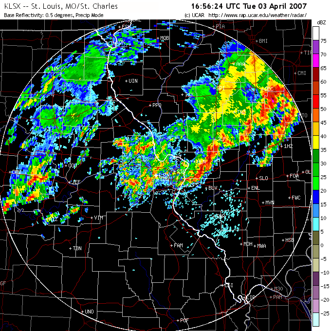
St. Louis radar image, from around the time the first picture above was taken
St. Louis radar image, from about th etime the last picture above was taken - Note not only the main line of storms where the picture was taken west of Pinckneyville, but also that severe storms are still occuring well behind the line in Madison and St. Clair Counties.
National map of storm reports for 4/3/07
Return to Weather Observation page