
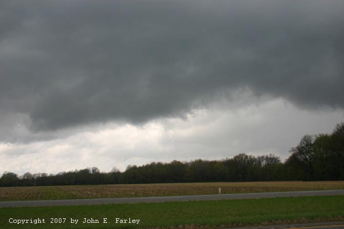
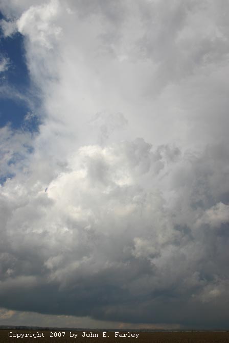
I headed out the door around 11:05, and reached the Robinson area by around 1:30. At that time there was a band of towering cumulus (TCU) running NE-SW right over Robinson. There were thunderstorms farther north, but they were moving over the cold air at the surface, so would be unlikely to produce tornadoes. When I say cold air, I mean it - cold enough for snow a couple hundred miles north of my location, in Chicago. I decided to follow the line of TCU and see what happened. I went north, then east, and crossed the river into Indiana at Hutsonville. At that point, the TCU above me turned into cumulonimbus, and I drove through a couple rather heavy bursts of big raindrops, though no hail. I then basically followed this cell north and east, at first on routes 154 east and 41 north, then on back roads from around Pimento up to near Cory, for around an hour and a half. Although by around 3 p.m. the weather radio was still referring to the cell as a shower, by then it was producing lightning. It started out as an individual cell under the line of TCU but became somewhat ellongated as it passed east of Terre Haute - but it remained pretty much discrete the entire time I watched it. It was very low based, and I did observe some shear (but not rotation) as the front edge of the base pushed north and the back edge south, at least in the storm-relative sense. However, it never had a real intense look to it. Here is a picture of the cloud base, taken at a time when the shear was quite noticeable, and here is a photo showing the storm structure after I finally broke away from it to try to get another storm to its south after following it for about an hour and a half.
Note in the latter photo that neither the updraft nor the anvil has a really hard look to it, and since I had been following it for at least an hour and a half and it had not shown any signs of much intensification, I decided to try something else. Naturally, the storm later, around 4:20, 5:35, and 7:25 produced a tornadoes near Harmony (EF0), North Salem (EF0), and Arcadia, IN (EF2). So maybe in retrospect, I should have stayed with this storm. But that's OK, because my chase still turned out just fine.
After wandering around for a while on Indiana's less than wonderful back roads, I decided that the southern storm was going nowhere, and heard SVR warnings for a new line of storms back in IL, northwest of Robinson, probably on the cold front. I decided a SVR-warned storm was better than anything I was watching, and tried to get back west to route 159 so I could get to I-70 and head west toward the storms. But roads going west for more than a half mile until they turn north or south seem to be a rarity in that part of IN, and the situation was compounded by the fact that, having only once before chased in Indiana, I do not have good maps of that state. So I wasted some time going in more or less squares that amounted to circles. Eventually, though I found my way back to route 159, and after a gas stop, got on 70 and blasted west. I could quickly see that my original plan of crossing into Illinois to intercept the storm was out the window. If I did that, I would get crunched by the storm or caught between it and the Wabash River. So I got off and headed south on 41. Now my memory was that Terre Haute was north, not south, of I-70, and most of it is, but the city has expanded southward quite a bit since I was last there. So for the first couple miles I was in a maze of red lights, traffic jams, and shopping centers. But eventually, I found a good spot to stop and view the storm, which by now was only a few miles west of me, moving northeast. A SVR was now in effect for the Illinois county just NW of Terre Haute. This storm was looking much better than the previous one. It was also backbuilding rapidly, and I figured if I stayed much longer in this location, I was going to get hailed on, so I moved farther south.
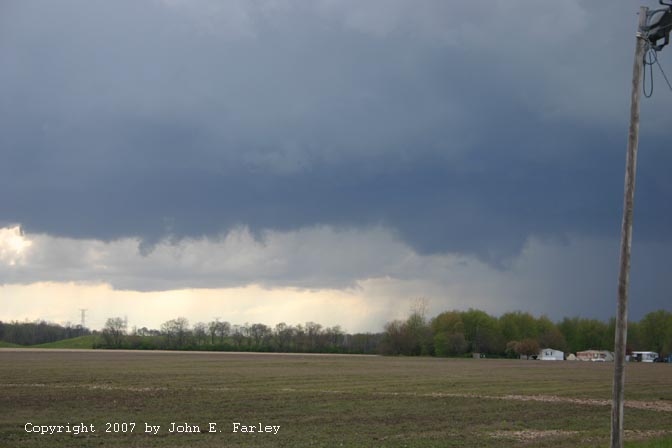
From a few miles farther south, I could see the entire storm structure, including a hard tower that was going up:

Under the updraft tower, there appeared to be a RFD notch cutting in. I figured, correctly, that Terre Haute was about to get some serious hail, so I stayed put and waited a while. Also, there was another storm to my south that looked interesting, and I could watch both from this location. After a while, though, I noticed some good sized lowerings on cells just east of the main line, and figured, too, that the Terre Haute storm had moved far enough northeast that I could get back to 70 without driving into anything too nasty, and then head east. I did hit some moderate rain and a couple chunks of hail - not sure of the size, but not more than penny as I drove north, and noticed accumulated hail on the ground from around the intersection of 41 and 70 for a couple miles east on 70. It was in piles and drifts 2 or 3 inches deep in places, and there was a report of 1-inch hail on the east side of Terre Haute.
As I headed east, I could see the storms were backbuilding again, and I began to be concerned about hail, as I noticed new precipitation falling ahead of me. However, if I was to have any chance to keep in position to see the storms, I needed to keep going, so I did. I hit some rain and a little hail, but only small hail. Then, about 20 miles east of Terre Haute, I noticed wild motion in scud tags ahead of me -they were going every which way. At first I thought they were moving anticyclonically, but that turned out not to be the case. I pulled out the video camera and got a little video, but promptly came on a couple state police cars parked on the median, so pulled down the camera so as not to get accused of inattentive driving. Within a mile or so after passing the police, I noticed that the rotation had tightened considerably. I was within a half mile of it, and it was just to the right (south) of the interstate. I did not feel it was safe to drive further, so found a safe place to pull over as far as I could. From that location, near mile marker 30 around 6:00 p.m., I shot this video:
This was the strongest rotation I have ever seen in a storm that did not produce a tornado (not then, anyway). It did form what I am pretty sure was a brief funnel right after I got the above video, but at that time I was concerned about how to safely proceed. I did not like being stopped on the side of the freeway, and figured I was better off to be ahead of the meso, but I did not want to drive into what could be a developing tornado.

Still image from video
After watching for a couple minutes, I became convinced it was for the time remaining south of the freeway, so I began to proceed with caution. As I passed perhaps a quarter mile north of the rotation, my car was bonked with exactly two hailstones, which sounded larger than anything else I had encountered, but I did not see them. Around the time I was just north of the meso, there was a large clearing to my right in the generally wooded terrain in that area and I did not see any evidence of circulation on the ground. I considered calling this in to the NWS in Indianapolis, but since it was not on the ground I decided to wait a bit and see what it did, as I did not want to cause a false alarm. However, I did not have to wait for long, as the warning alarm went off on the weather radio and a tornado warning was issued for Putnam County based on radar indication of strong rotation at my exact location. They stated that I-70 between mile markers 30 and 34 was a dangerous location. The next mile marker I passed after that was 35. When I got to the next exit, I was ahead of the circulation and got off for a look. The last part of the video was taken from there, but as I say on the video, it was clear I was still in a location where the meso could pass over, so I felt that I needed to head east.
By the time I got to the next exit, the meso had crossed over I-70 and was becoming rain-wrapped to my northwest. As it disappeared into the rain, I was blasted by a wet RFD. This was the most hail I encountered all day, but all of it was small, pea size or smaller. I called NWS Indianapolis to let them know there was indeed strong cloud rotation where their radar had indicated storm rotation. Around this time an update indicated that the radar was still indicating a possible tornado near Putnamville, a few miles to my northwest. I watched a few more minutes, but it was becoming evident that the storm was weakening and was becoming surrounded by many areas of rain and thunderstorms. Minutes later, the warning was cancelled because the storm had weakened. It looked like this area, anyway, was turning into an area of widespread rain and non-severe thunderstorms, and I was again behind most of it, so I decided to call it a chase. This storm did reintensify and produce an EF1 tornado later near Lizton, but I don't think I could have gotten in position to see it, even had I continued. It would have been difficult to continue the chase and see anything from where I was the way the storms were filling in.
Edit: After looking at the track map on the NWS Indianapolis Web site, I do not think the Lizton tornado came from the same meso that produced the rotation I saw - the track is farther north than a continuation of the meso I observed, and is also well north of where the rotation was indicated on an update around 6:20 on the Putnam County warning. Hence, although the Lizton tornado was associated with the same line of storms, I think it came from another meso up the line a bit from the storm I was observing.
A couple final thoughts. One is that the rotation seemed to develop as a cell in the main (but broken) line of storms caught up with more isloated cells ahead of the line. The other is that, although I am very pleased with the video I got, I do not usually chase storms from interstate highways except to get in position, nor do intentionally get that close to a rotating wall cloud. Moreover, because I was on the interstate with no nearby exit, I was somewhat concerned for my safety. I got into that situation because the meso formed very quickly where there had been none a few minutes earlier - I was just using the interstate to try to get back ahead of the storm. I could see what was going on so was not too worried, and did not proceed until I was pretty confident the meso would stay south of my path until I could get past it. But neither being stopped on the side of the freeway nor passing that close to a rotating wall cloud is my preferred way of doing things.
Despite that tense moment, I am very happy to have had a successful chase on my first try at a cold-core system. Now I see why some storm chasers like these so much!
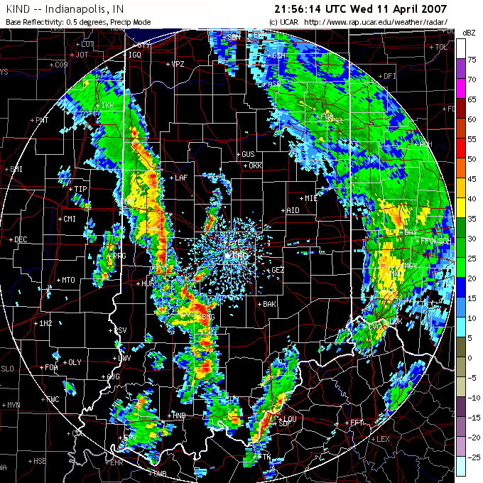
Radar from the approximate time I observed the rotating wall cloud - It is the cell right on I-70, northeast of HUF (Terre Haute airport).
Preliminary Local Storm Reports
National map of storm reports for 4/11/07
Total chase distance: 460 miles.