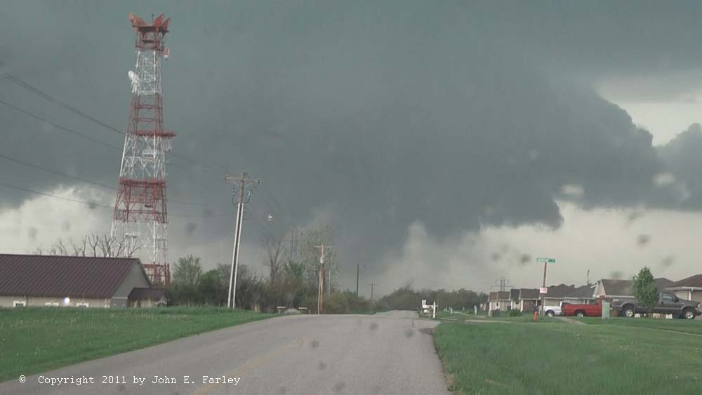
Looking northwest from about a mile west of Holt's Summit. You just don't see structure like this in central MO very often. (The trees you do see, though, lol.) Note: This and all the pics here are video captures, unless otherwise noted.
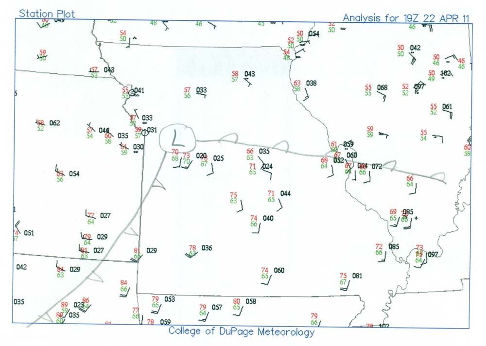
With a similar setup to the system 3 days earlier, low pressure would be passing just northwest of St. Louis, pulling a warm front northward over eastern MO and IL, then dragging a cold front through the area as it passed. Early on the models were not showing as strong a system as the earlier one, but by the morning of today's event, the short-term models (RUC and HHHR) were showing a stronger system than the previous day's models had forecasted, with CAPE progged in the 3000-4000 range and EHI again hitting insane levels of 6-12. I was at first hoping to chase in IL, but by around 2 pm it was becoming clear that the system was not going to make to IL during daylight, necessitating a chase in the less desirable terrain of MO somewhere between Columbia and St. Louis. Already by this time CAPE was 3500 to the southwest of St. Louis according to the SPC mesoscale analysis, and that very unstable air was working northeastward toward the I-70 corridor between STL and COU. The warm front, which had been temporarily pushed back south by morning storms, surged back north to near the St. Louis area around 2:00 p.m., and through it by around 2:30 p.m. It looked like storms would mostly fire on the cold front, but the directional wind shear was decent so even there, the storms would likely include supercells. I figured that whichever of these was closest to the warm front would have the best chance to produce a tornado, so I headed west a little before 3, targeting the area between about Montgomery City and Fulton, and figuring that I would go after the best looking storm, probably one relatively close to the warm front just north of I-70. A map showing the 19z (2 p.m. central time) weather station plot with my analysis of the positions of the surface low and fronts can be found here.
As it turned out, no supercells made it north of I-70, but the northernmost one, closest to the warm front, did turn out to be the storm of the day. As I headed west on 70, I saw on radar that it had popped up southwest of Columbia, and watched it become the first SVR warned storm in central MO and soon after, the first tornado-warned storm. It remained tornado-warned for the next 5 or 6 hours, all the way eastward to around Effingham, IL. As I headed west on I-70 figuring to head southwest on U.S. 54 for an intercept of this storm, I worried about the road network, as there are basically no through east-west roads between 70 and MO route 94 which basically follows the Missouri River, and getting back to 70 after intercepting the storm would not be easy given the storm's motion. But the decision was made for me when I saw a massive 5-mile backup on the other, eastbound, side of I-70 due to a series of accidents, eliminating that as an east option. I would have to hope the storm would turn enough right that I could stay close to it on route 94, which it did end up doing. After an initial movement to the ENE, the storm quickly turned right and moved straight east. With some occasional wobbles and some variation in speed (but averaging a fast 40-50 mph), the storm maintained this general due-eastward motion the rest of the way across MO and a good half of the way across IL as well. This one definitely turned out to be the storm of the day, an intense long-track supercell.
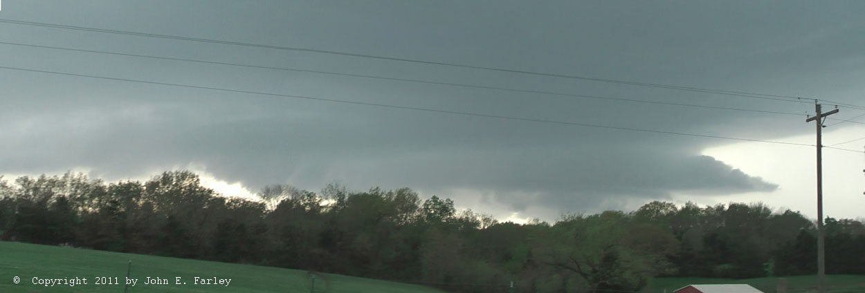
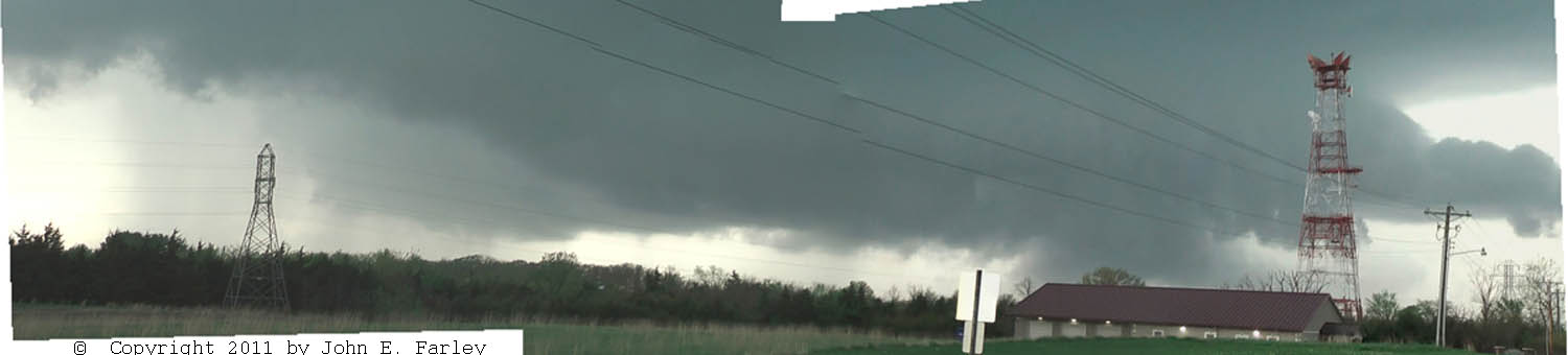
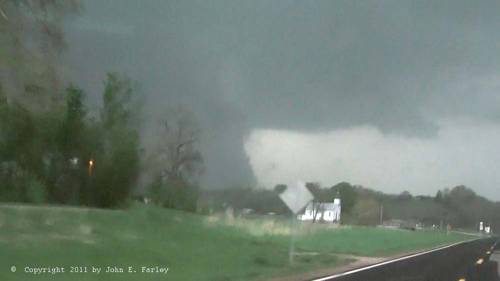
My timing was good, and I intercepted the supercell around 5:25 a mile or two west of Holt's Summit, MO (which is about 6 miles north of Jefferson City). It had a nicely backlit mesocyclone with a pronounced inflow tail. Here is a panorama made from two video captures showing what the storm looked like when I initially intercepted it:
Looking northwest from about a mile west of Holt's Summit. You just don't see structure like this in central MO very often. (The trees you do see, though, lol.) Note: This and all the pics here are video captures, unless otherwise noted.
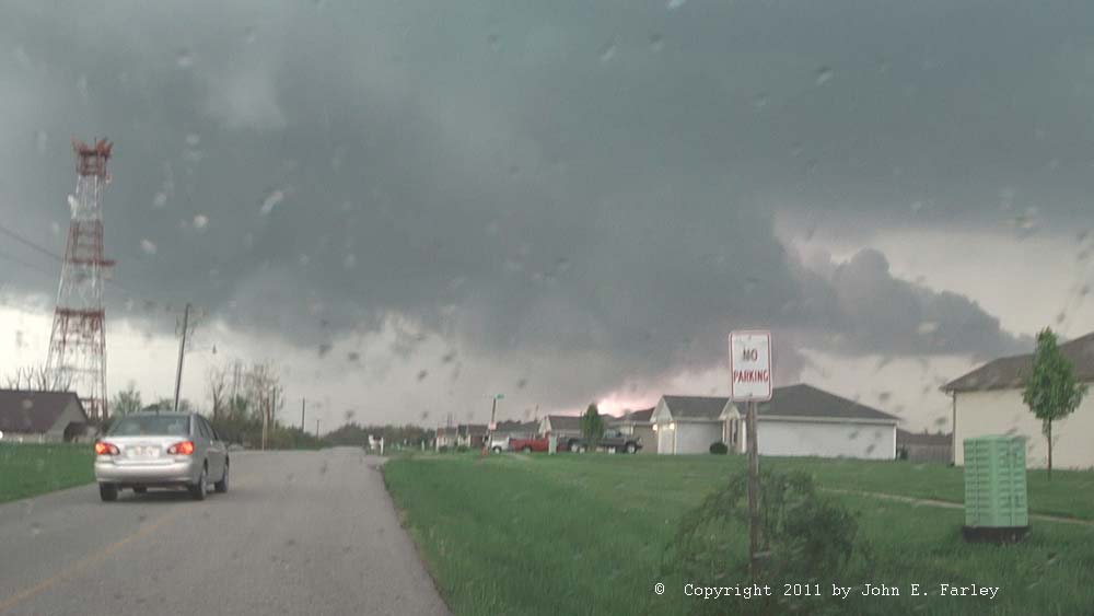
I watched it for a few minutes, then backtracked to Holt's Summit to stay with it. This area is very hilly and wooded, and finding a good viewing spot is not easy. But there was one place at the edge of town where I had a decent view, and watched the storm cycle as one meso occluded and a new one quickly formed just to its east . A panoramic photostitch of 3 video captures, showing both the old, occluding meso at the left (west) and the new developing one to the right (east), can be seen here. The new one quickly tightened and lowered, and I thought a tornado might be imminent:
Looking north from Holt's Summit, about 5:35. I like this picture because of how the lightning illuminates the rotating wall cloud.
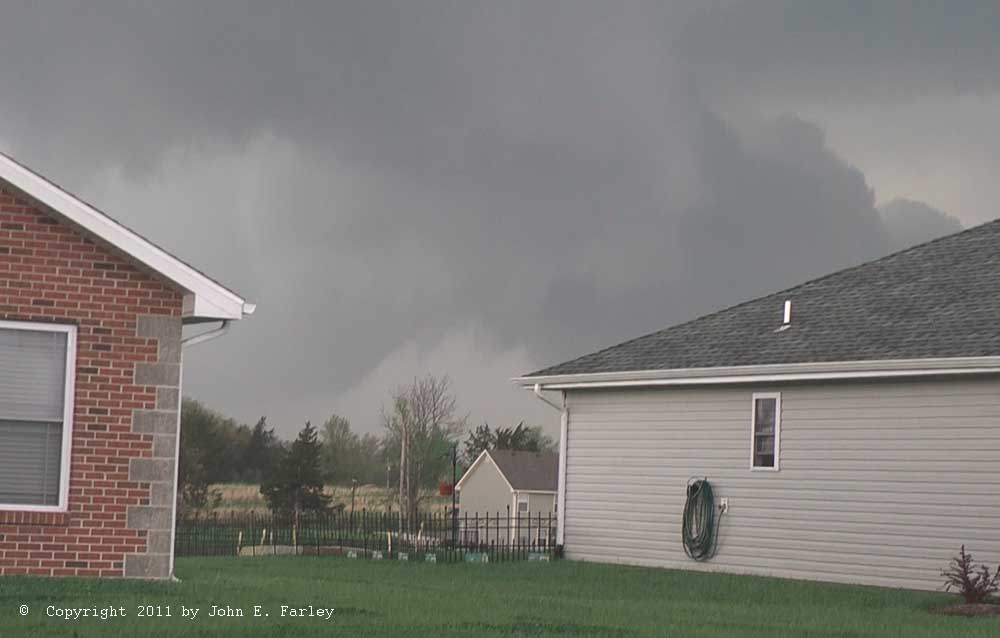
Shortly after I got the capture above, there was another flash of lightning under the lowering that I thought could have been a power flash, but the video seems to indicate a lightning flash. As you can see it is about to disappear behind a house, so I moved down the street and got one last view before I had to move on. Around this time I thought it had more the look of a funnel than a wall cloud, and a couple reports from spotters closer than I was support the idea that this was the case. I thought a tornado was imminent at this time, but apparently it did not quite touch down. It was crossing a busy highway at this time and would almost certainly have been seen if it had touched down, but there were no tornado reports from this area.
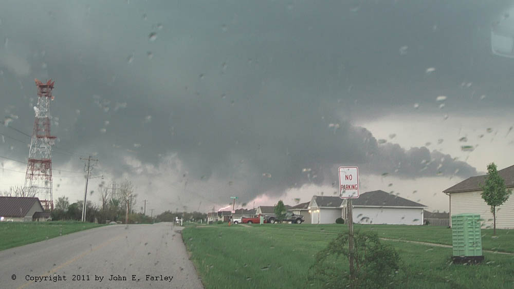
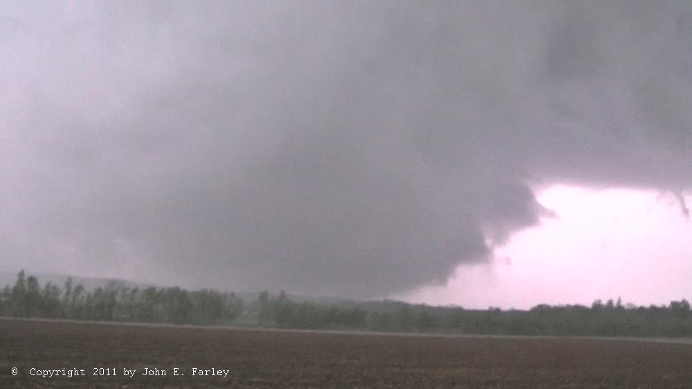
I knew now that I had to get east to have any hope of keeping up with the storm. Since I had to drop south a few miles to get east on route 94, the storm got ahead of me. But route 94 follows the Missouri River roughly eastward (mostly at the foot of the bluffs on the north shore of the river, but occasionally making annoying ventures into the hills and trees for a few miles), so I thought it would be a decent route for going after the storm, and that proved to be the case, for a while anyway. With the rapid 40-50 mph movement of the storm, it took me almost until Hermann to catch up, occasionally getting blasted with strong RFD wind (which made me nervous when I was in the trees, but it remained below the strength that would have brought down large branches) and at times heavy rain and a few small hailstones. I saw some larger ones, up to an inch and a quarter or so, on the ground, but the really giant hail thankfully stayed north of route 94. A few miles northwest of Hermann a little before 6:30, I had finally caught back up to the meso and could catch occasional glimpses of a ground-hugging wall cloud just to my north or northeast. My location at this time was between Rhineland and McKittrick, 4 or 5 miles northwest of Hermann. Shortly later I could see traffic stopped up ahead, and thought the police might have the road blocked to keep people from driving into a tornado. But when I got there, I could see it was a string of mostly chasers who had stopped to get the only clear view in miles. Although they stopped in the road because there was no shoulder, it was not a particularly big deal since the only traffic was chasers and maybe a few locals out look looking for naders. So I just stopped at the end of the line and got video, too. Here is what I saw there, just after 6:30 p.m.:
Looking north from 3 or 4 miles northwest of Hermann.
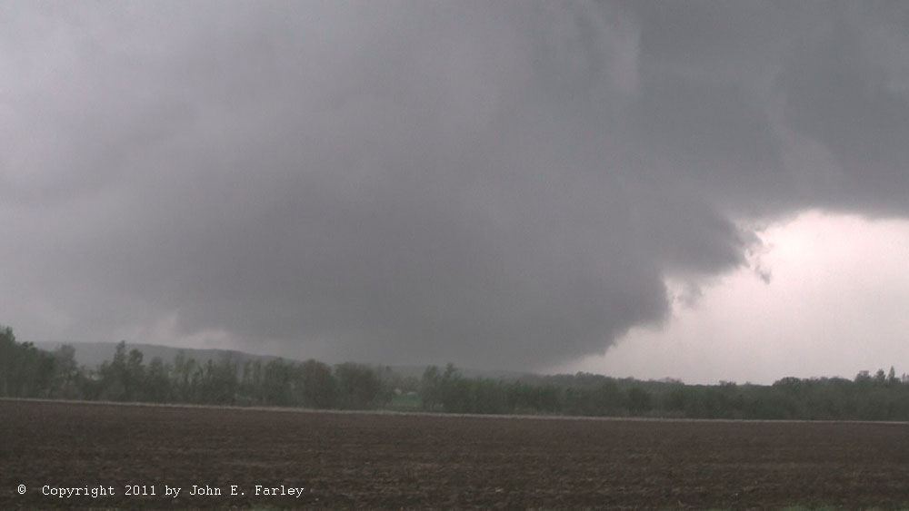
Here is an image of the same feature illuminated by lightning. There were no tornadoes reported here, but this sure looked like it could have been. This was a more remote location than where I saw the earlier funnel cloud, though, so it would not surprise me if there was something back in the woods somewhere. OTOH, some photos by other chasers farther away show more of a gap between the bottom of the wall cloud and the ground, so IF they were taken at the same time as these pictures, they would suggest a non-tornadic wall cloud. There were hills and trees here, as you can see in the pictures, so it could be that there was some gap between the cloud and the ground that I could not see. In any case, this feature was strongly rotating and the wind field circulating around it was pretty strong, and my video shows what appears to be a brief funnel on the front edge of the wall cloud. However, the rotation at this point apparently did not tighten up enough to get a significant tornado. There were multiple reports of baseball to almost softball sized hail, though. You can see pictures of some of the 3-4 inch hailstones on Dan Robinson's chase report, linked below.
After this I got one more decent wall cloud view from northeast of Hermann, but it wasn't nearly as low as the one above. However, it was clearly rotating. This would have been about 20 minutes before the first report of a tornado with this storm, near Warrenton. Also saw the Dominator race by at that last stop northeast of Hermann-first time I know of that I have been on the same storm as Reed Timmer. I later learned that, although he bagged multiple tornadoes in the event 3 days earlier, this was his first day this season chasing in the Dominator.
After that I got behind due to a bridge out near Marthasville, and couldn't catch up. I lost some additional time by briefly making a move toward the next storm south, also tornado-warned and a long-track supercell - but by the time I had driven 3 or 4 miles to Washington, it was obvious that I wasn't going to get to it without a serious core punch. So I turned around and headed north to Foristell, briefly considering but deciding against going into New Melle to view the damage there.
Later, after I got back up to I-70, from Foristell and for a few miles eastward, I saw a big lowering in the distance that I initially discounted as a scud bomb but then saw a large updraft tower above and eventually heard a report of the Maryland Heights tornado in that general direction. The setting sun gave the lowering and the clouds around it a strange orange-to-pinkish color. At first I discounted the possibility of this being the wall cloud or tornado, figuring that it would have been hidden by rain. But after some analysis of the map and the time, the feature I saw was in about the right place to have been the meso of the storm around that time. Additionally, a picture that appeared on the NWS damage survey page of a wall cloud viewed from O'Fallon and pictures included in a chase report on Stormtrack by Kevin Crawmer (taken at highway 40 and route N) clearly show the same feature that I was seeing. Kevin confirmed to me that the feature was slowly rotating, and his picture also shows an inflow tail coming in from the east. Thus this feature clearly was indeed a rotating wall cloud. And while it is hard to tell the exact position of this feature, it clearly was between highway 40 and interstate 70 when I saw it around 7:45-7:50 or so and when the other observers saw it. Thus I think it could either have been the wall cloud of the tornadic storm, or it could have been another wall cloud on the next storm just southwest of the tornadic storm, as the storms were becoming a bit more linear at this time. While I am not sure of the exact location of this wall cloud, I would say the most likely place was just south of St. Peters, near Howell. The damage survey shows that the long-track EF4 tornado in St. Louis and Madison Counties began about 5 or 6 miles east of this location, and about 5-10 minutes after I saw this feature. So unless another tornado is confirmed in this part of eastern St. Charles County, I didn't see an actual tornado on the ground, but I may have gotten a glimpse of the developing stages of what would become one of the most intense tornadoes ever to hit the St. Louis area. I didn't get a picture or video, partly because I was in heavy freeway traffic and partly because I discounted it at the time. After a few minutes, it disappeared into the rain.
I took route 40 rather than route 70 through St. Louis, partly to avoid the core and partly in hopes of getting back south of the storm where I might regain a view of the area of interest. I am actually surprised with the amount of time I lost between the bridge out and the abortive move toward the southern storm that I was still able to get as close to the storm as I did; I rather suspect that the motion of the storm slowed for a while as the series of tornadoes began near New Melle. However, this time I was not going to catch up to the storm - first I saw one of those lighted signs indicating an "incident" ahead, then the traffic slowed to a dead stop and was stop and go for several miles; perhaps this was triggered by a tornado crossing the freeway or maybe it was just an accident or the result of hundreds of panicked drivers. Jesse Risley's chase report, linked below, suggests that a weak tornado may have crossed the road there; with the rain-wrapping going on at the time, it was hard for his group to tell. But certainly it impacted traffic, as people stopped, some at the warning of the chasers in the area, to avoid driving into a possible tornado.
There were lots and lots of people on the shoulders under the underpasses on both sides of the road when I came through this area and at various points eastward, even though the storm had passed. However, I also heard some sirens going off in areas where the storm had passed, so can't totally blame drivers for being scared, but getting under underpasses is NOT the thing to do. At least they didn't stop on the actual highway. While the traffic was stopped, I took video in hopes of getting the tornado silhouetted by lightning - probably around the time Bridgeton was hit - but by then it was again too rain-wrapped to see from that direction. Never did catch up with the storm again after that slowdown; took 255 to 270 to get to Edwardsville rather than going through the core on 55/70.
All in all, this was a challenging but fun storm-chasing day; my forecast was accurate and I did about as well as I could have given the limited road network. Most important, I saw a spectacular and historic supercell storm. I know, though, that it was not fun for the people at Lambert Field or whose homes were damaged by the tornado, and my heart goes out for all of them. Great credit is due to the St. Louis National Weather Servie, the St. Louis area media, and the local warning system: Although a large, destructive tornado, reaching an intensity as high as EF4, traveled 22 miles through a densely-populated major metropolitan area, there were no deaths or even serious injuries. There were a number of injuries at Lambert Airport, but all were minor, only a few required hospital transport, and none required an overnight hospital stay. In the days before today's warming system, many would have died in a tornado like this; it is a testimony to the success of our tornado warning system today that nobody did in this devastating storm.
Here is my video from this chase:
There are three main parts to the video. The first part of the video is from the Holt's Summit, MO area. It shows nicely-backlit lowerings in the tornado-warned storm as the storm cycles, i.e. one mesocyclone occludes and wraps up in rain as a new one forms to its east and forms a menacing wall cloud and a funnel cloud. The middle part of the video is from along MO route 94 in the Hermann area, and includes the ground-hugging wall cloud I watched as the storm produced 4-inch hail north of Hermann. This part of the video ends with Reed Timmer passing by in the Dominator with lots of people following him in hopes he might lead them to a tornado (though some may have been part of his film crew also). The final part of the video, taken along U.S. 40/I-64 in St. Charles County, shows lightning in the storm around the time Bridgeton, MO was hit by the EF-4 tornado. You can't see the tornado, though, due to low clouds, rain, and darkness, which hid the tornado from even those who were close to it.
Total chase distance: 325 miles. (And in addition, I chased 120 miles on the morning storms, too.)
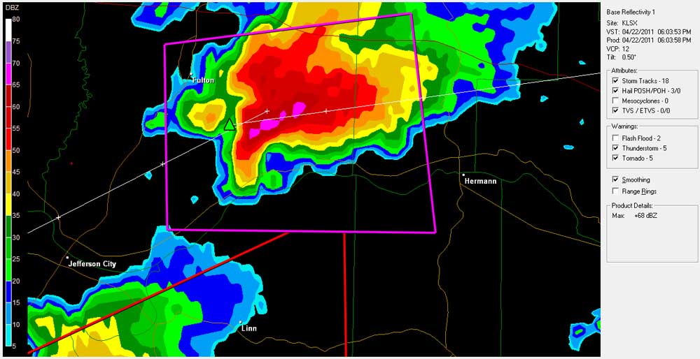
Reflectivity Radar Image of the storm at 6:04 p.m.
Other reports and information on this storm:
National Weather Service Damage Survey for this storm
Stormtrack chase reports page for this event (also includes Texas and Oklahoma events the same day)
Return to 2011 Storm Ovservation page
Return to Severe Weather Observation page