7:30 a.m. - I left Santa Fe, NM amid rain and snow - yes, SNOW - showers. Now, I know that supercells and snow on the same day is not totally unheard of, but I'd say it is a little unusual in May. I was heading east and northeast toward a target in northwestern OK, just east of the Panhandle, or perhaps just north of there in far southwestern KS. It appeared that the dryline would set up camp along the eastern edge of the OK and TX panhandles and pretty much stay there all day, with the best dynamics just to the north of that area in KS, where a high risk had been issued by SPC. All up and down the dryline, though, the models were forecasting storm parameters off the roof, with CAPE of 3000 up to as high as 5000, and SRH ranging from 200-300 and higher in places.
Around noon, I saw towers way off to the east as I approached Boise City. The storms had initiated earlier than I had hoped, meaning that I would likely be playing catch-up, unless they simply kept re-firing along the dryline all day. The storms were still 100+ miles away from me at this point, meaning I was not likely to reach them until around 2:00. When I reached Guymon, the storms were still well ahead of me - I was hearing reports on the radio of severe storms around and east of Buffalo, still far ahead. At this point, I made one of those decisions that turn out to have a big impact on the outcome of a chase - I decided that rather than go NE into KS, where I figured that the numerous storms might turn into a big, messy MCS, I would target the tail-end storm which appeared to be near route 412 in OK, figuring also that storms that developed to the south of there in the more capped atmosphere would stay more isolated. Good in theory, perhaps, but had I gone to KS, I might have seen multiple tornaodes, as many who initially went there did.
As I expected, I caught up to the storms around 2:00 p.m. and observed the tail-end storm which by now was a little to my NNE near Buffalo, OK. Lots of other supercells were farther up the line to its NE, in Kansas. I decided to let it go, as I would have to play catch-up to get position on even the tail-end storm, and then I might not have been able to get good position on the storm which was moving fairly quickly to the NE. As I said earlier, I expected other more discrete storms to develop to south, but this was very slow to occur. I decided to head a bit SE to Woodward to get gas, food, and data.
From roughly 3:00 to 5:00 p.m., I watched, waited, checked data, and filled my tummy and my gas tank. I was able to get a wifi connection, and could see that up to around 5 p.m., no storms were occuring near or in the area southwest of my location. However, what I was seeing in the data, hearing on the weather radio, and reading in the Stormktrack NOW thread for the day all said the same thing: expect redevelopment of severe storms in W. OK along and near the dryline.
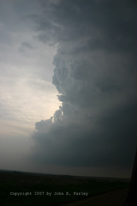
Shortly after 5 p.m., a new storm fired and rapidly intensified in the Buffalo area, 30 miles or so to my NW. I went after it, undoubtedly influenced by the failure of the earlier storms to develop southward from that area. A second storm formed soom a little to its South, and this one became my target storm. However, a poor road choice soon had me playing catch-up again, and turned out to be VERY costly to me. Rather than going directly north to Buffalo, I figured I could get to the tail-end storm more quickly by going to May and then north to Laverne, However, the storm moved too fast for that strategy to work, and I was again left in less than the optimal position, approaching the storm from the south and trying to catch up rather than positioning myself to the east of if as I should have. Nonetheless, it was a beautiful supercell, with a hard tower, a nicely backsheared anvil, and a persistent lowered area on SE side. It soon went TOR-warned for E. Clark and W. Commanche Cos. KS at 5:34, around the time I was approaching the storm from the south near Laverne. The storm produced several reports of large hail from around Laverne up through the Protection, KS area.
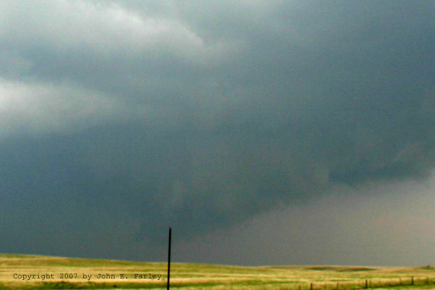
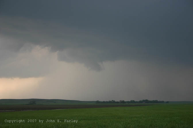
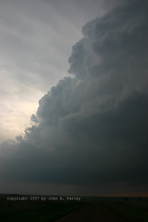
I chased the storm from Laverne north then east to Buffalo, north into KS, east to Protection, and north again about 6 mi past Protection. There were lots of chasers, and some bonehead behavior, such as stopping vehicles half-blocking the traffic lane and walking around in the road. This seemed to be associated mostly with multivehicle caravans, from what I could see. The storm maintained a persistent lowering southeast of the precipitation core, and had lots of cloud motion in several areas under updraft. Here is a more zoomed view of the wall cloud:
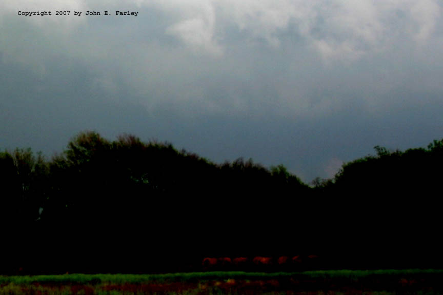
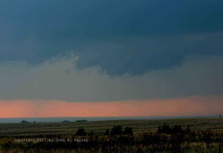
As I got to where the paved road turns west, about 6 miles north of Protection and 8 or 9 miles WNW of Coldwater, I faced confusion along with lots of other chasers. The road north was too muddy to continue - lots of abrupt stops by those who started into it, and going west or back south meant losing the storm. Just then, a tornado was reported by a chaser about 5 miles west of Coldwater at 6:35 p.m. This would have put it about 3 miles east of my location. I saw nothing that I could confirm as a tornado, and I have seen no reports from chasers in this area that definitively report seeing a tornado, though some said "possible tornado." After reviewing my photos, I will say the same, as I found an interesting feature in this picture. Look at the low spot in the tree line on the right-hand side of the picture - there is something there that COULD be a tornado or funnel cloud, and it would have been pretty close to the right place - a few miles to my ENE somewhere around 6:40. If anyone reading this can confirm that a tornado definitely did occur west of Coldwater around 6:35, please email me.
********
UPDATE - NOVEMBER 19, 2007
Now that Storm Data is out, I see that a tornado was confirmed with this storm from 6:33-6:37 northeast of Protection and west of Coldwater. Therefore, the lowering in the picture above MAY be the tornado, but given that a decent view was blocked by the trees, I will never really know. What I do know is that 1) this is the closest I got to seeing a tornado on this day and 2) If I had been ahead of the storm instead of behind it due to my bonehead road choice, I would likely have been in position to see this tornado and possibly several others that the storm subsequently produced. Until I saw Storm Data, I was not sure whether or not it was this storm that produced the additional tornadoes in Kiowa, Edwards, Pratt, Stafford, and Pawnee Counties, including an EF2 that was on the ground for nearly 27 miles. I was not sure until I read Storm Data that it was my storm that procued all these tornadoes, but it was. However, being behind the storm and on the road that turned to mud north of Protection precluded my being in position to see these tornadoes. So now I feel better about my forecast, but worse about my navigation error! Had I not made the navigation error and thus been in better position, would I have continued east of Protection rather than turning north there, and thus had the best position on the storm? Could I have gotten past the closed roads in the Greensburg area to keep up with the storm? I'll never know, but I probably would have gotten a good look at least at the first tornado (NE of Protection and W of Coldwater), and maybe seen some of the later ones, too.
********
Unable to follow storm further, I focused for a while on another storm to its NW which had a nice updraft with a lowered area underneath:
I watched that storm for a while, but then decided to shift back S to intercept a SVR-warned supercell coming into the Coldwater area from OK, figuring that storm would have access to juicier air than the one to my NW, whose inflow was certainly being contaminated by the storm I had been watching.
After driving through rain and a little hail being thrown out of anvil along route 160 east of Protection, I got on the new storm a little S. of route 160, south of Coldwater. It had great supercell structure, intense CG, and a small wall cloud in which I could not see any rotation. Here is a picture showing the updraft towers and rain-free base (before the wall cloud formed). This picture, slightly more zoomed, was taken a few minutes later as the storm became more tilted/sheared. While I was watching and photographing the storm, another chaser pulled up alongside and also photographed the storm, and we chatted a bit about the storm. Being mostly concentrated on the storm, we did not exchange names, but I think it was Sam Barriklow, as his pictures of the storm and the location appear to be the same storm and location as mine. (It was indeed, as we later confirmed by email.) A little later, after the wall cloud formed, there was an interesting feature apparently under the wall cloud for a brief time, as shown in this picture. I think it was most likely a rain shaft from another storm behind the one I was watching, but do note its position relative to the angled lowering on the left (south) side of the wall cloud. Apparently, there was some jumbo hail in the vicinity of this wall cloud, as Storm Data reports 3.25" hail in northeast Clark County around this time. I eventually followed this storm to just north of Coldwater, where it moved across the road several miles ahead of me. At that point, I broke off the chase and head west, back toward NM, around 8 as the light faded and storm got away.
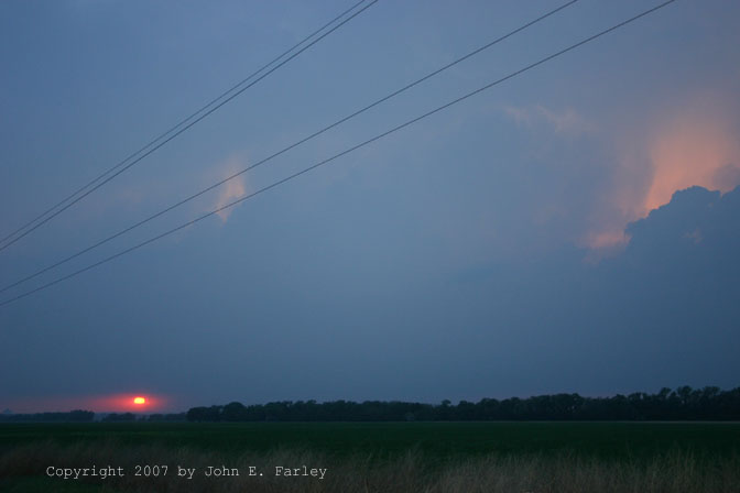
There was still more to see, however. First, I caught a nice chaser sunset SW of Protection around 8:20 p.m., as the sun shined under the RFB in a break between two storms in the second line of storms behind the leading one I had mostly been chasing. At this point I was not planning to chase the next day (though I later changed my mind. To get west, I had to cross the second line of storms. I crossed under a break in the squall line near Clark-Meade county line. This was probably around 9 p.m.; I encountered rain and a little small hail. Just NW of the line of storms, I stopped to video lightning, which had become very frequent but was mostly within the clouds with few bolts visible. Then, the storm to my south in the line went SVR warned, including for my location. A little hail started up again, so I moved farther west. I got more lighting video in Meade at a gas stop; now there were nice anvil crawlers. I also set the camera on the bottom of my passenger window at a stop just west of Meade and got this:
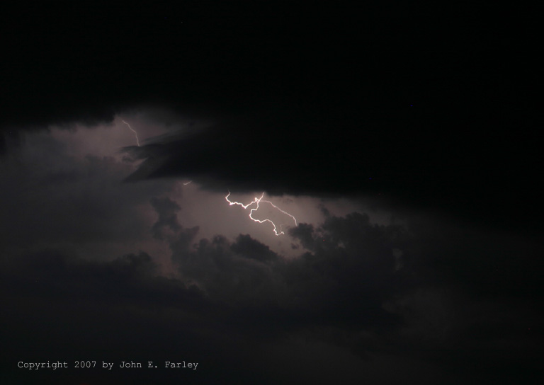
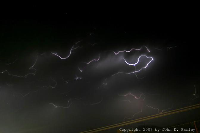
I arrived Liberal, KS around 10 p.m. I checked into a motel and then photographed and videotaped the now-spectacular display of anvil crawlers/in-cloud lightning to my SE from line of SVR-warned storms. As it turned out, this was one of the most interesting things I saw on this chase, one of the most spectacular displays of in-cloud lightning that I have seen. All of the many bolts in this picture occurred within just 16 seconds, the time of the exposure. I also got some nice video. The mpeg version linked below doesn't totally do it justice, but - especially if viewed full-screen, is still pretty impressive:
Video of lightning can be seen here
While I regret road choice decisions that cost me chances to see tornadoes, I still saw some awesome storms today, capped by a great display of lightning at the end. You never know what Mother Nature has in store for you when you head out to observe storms!
Here are some radar images:
Radar from 6:00 p.m. - The storm at the OK-KS border is the one I am on. One-inch hail is reported in Lavere, OK around this time.
Radar from 6:34 p.m. - The first storm I was on has moved up into the Protection/Coldwater area, while the second is following, to its southwest in NW Oklahoma. This is during the time the tornado was occurring west of Coldwater.
Radar from 6:55 p.m. - The second storm is now crossing into KS. This is a few minutes before the start of the long-track tornado began in the first storm, up in Kiowa Co., KS.
Radar from 7:30 p.m. - The second storm is now about over Protection. Note the squall line that has now developed behind the leading broken line of supercells.
Report updated November 19 with information from Storm Data.
Return to Severe Weather Obeservation page