Again, it looked like it would be a late show, which gave me time to visit Billy the Kid's grave southeast of Fort Sumner. Interesting place to visit if you have some downtime on a chase, and there are good public restrooms there, too. After a leisurely lunch of an Allsups eggroll (yes, they have those too, not just burritos) in a park in Fort Sumner, I noticed that a strong storm had gone up just east of the Sandia/Manzano mountains around Estancia and Moriarty. I did not go after this storm for two reasons. First, although there was indeed a narrow strip just east of the mountains where several models were forecasting high instability and good wind shear, the overall parameters seemed better farther east, in the area SPC flagged as enhanced risk. Second, the pattern the previouis two days had been for strong storms to go up in or near the mountains, and even become SVR warned, but the better storms went up later over the eastern plains. Congratulations to the handful of chasers who ignored these considerations, because those of them who were sufficiently patient were rewared by a couple of late afternoon tornadoes near Encino - tornadoes I could have very easily have seen if I had gone after that storm and stuck with it for 4 hours or so. From 1:20 through 2:30, the storm produced up to 1.5 inch hail, which broke some house windows. And around that time, it already got a couple tornado warnings, although apparently there were no tornadoes then. It then weakened for a while, but pulsed up again by around 4:30. producing up to baseball-sized hail and, around 5:30, at least one and probably two tornadoes near Encino. But I, and most of the chasers who were out that day, did not see them, because we stuck to our forecasts and were on storms farther east. I still think most of the time it is best to stick with your original forecast, but this is one day it was not in my case.
So, sticking to my target, I hung around Fort Sumner after lunch. By around 3 p.m., there were agitated cumulus around Fort Sumner, and by 3:30, spotty showers and thunderstorms were under way both north and south of Fort Sumner. It took another hour or so for them to become well-organized, with stronger storms north of town, drifting very slowly to the northeast. Then another storm popped up northeast of Fort Sumner and northwest of Melrose, and intensified rather quickly. This became my target storm.
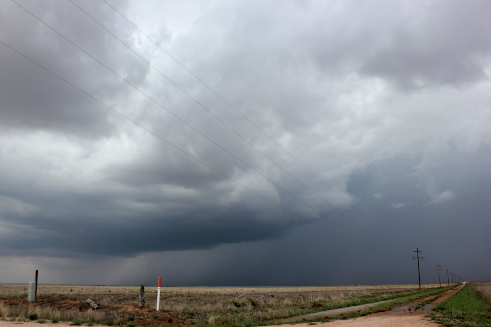
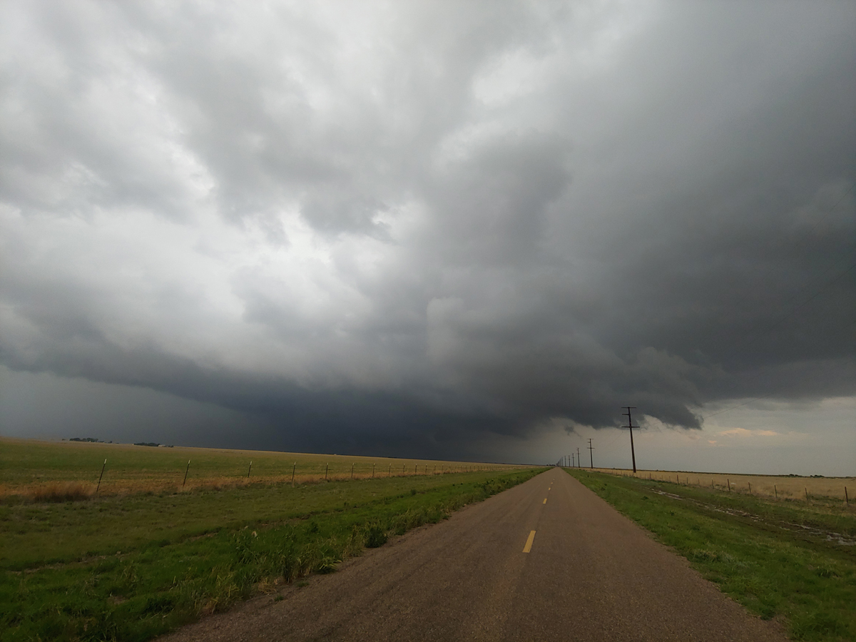
I headed north from Melrose on state route 268 as the storm continued to intensify, and became SVR-warned. Once I was close to the storm, I jogged west on a gravel road to get a better view of the main updraft area. (I was pretty confident at this point that the storm, which seemed to be moving somewhere near due east, would stay north of me and the road would not become impassible.) Around 5 p.m., I got this picture of the rather nice structure the storm displayed:
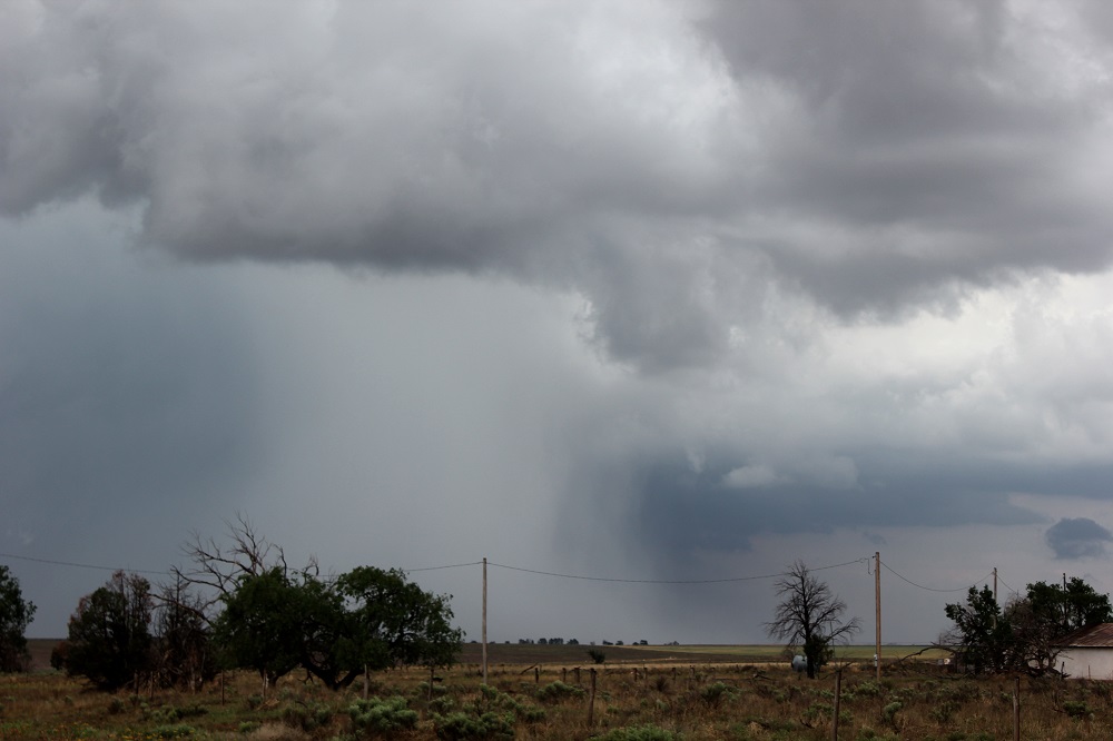
This was the main updraft, but the storm had become rather elongated east-west and may have merged with another storm that started just to its east. It then seemed to weaken or cycle somewhat, so I went back to route 268 and headed north into the area the storm had just passed through. I turned east on state route 288, again passing what I think was the (at the time inoperative) Cannon AFB NEXRAD radar site, to try to catch back up to the storm. I stopped not far from the radar site around 6:05 p.m. to take pictures of intense hail shaft that had formed to my southeast.
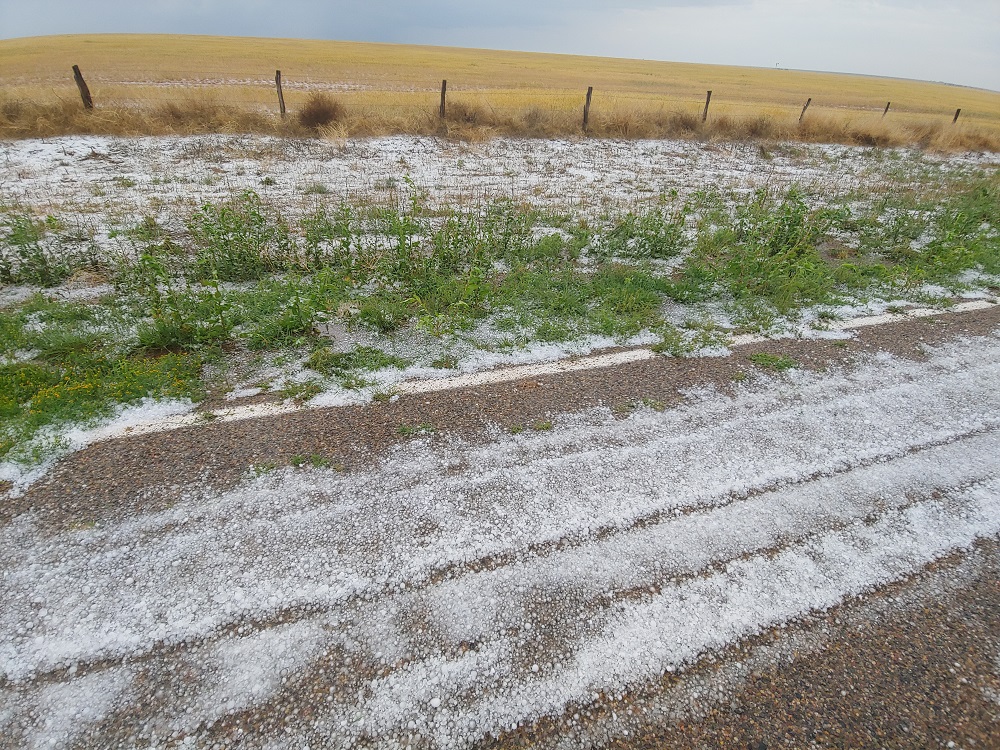
Since I was NW of the core of the storm, I turned south on state route 224 to try to get in position to catch up with the storm without driving into it. Shortly after where it jogs south, then east, then south again, I reached the hail swath around 6:20, where the ground was covered and I measured uo to quarter-sized hail.
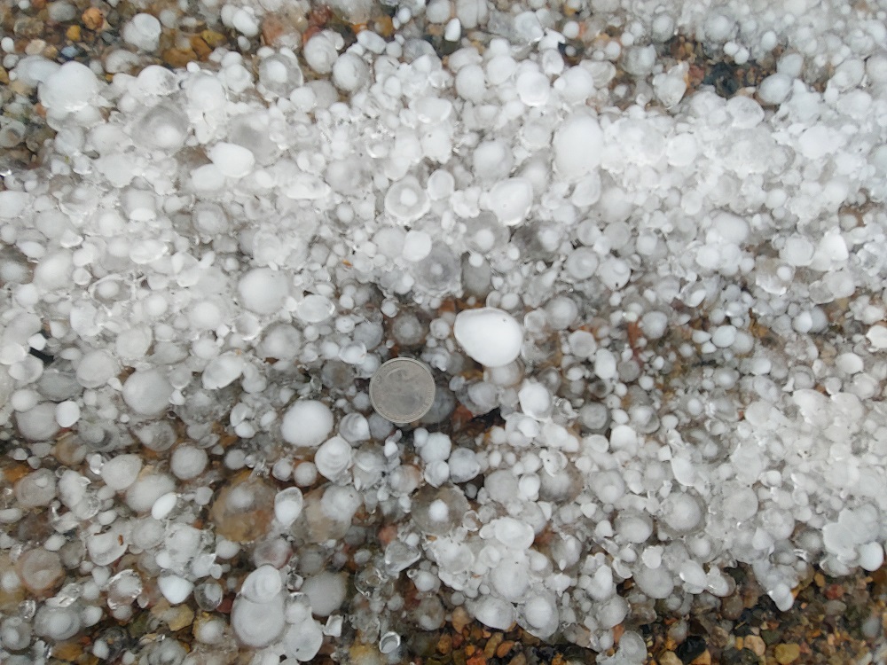
I did see a report of larger hail, around golfball size, a little farther east, and I also encountered several places with water over the road. This was only for very short stretches of road, and never more than around 3-6 inches at the deepest. Eventually, I turned east and followed state route 311 as it worked its way east and occasionally south. This got me closer to the storm and about due west of it, and I could see that a strong meso had formed, though I could not see what was underneath.
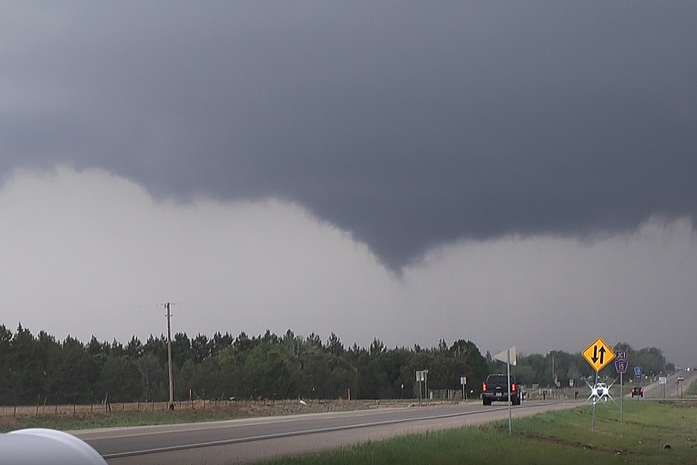
There was rotation in the cloud base, but the storm was about due east of me and moving away, albeit slowly, so I decided to move along. When I got to state route 245 I turned east and travelled to the north side of Clovis, where I turned left (north) on state route 209, the main north-south route through Clovis. Here, I became part of what was probably, for a short time, at least, the largest crowd of storm chasers I have encountered in New Mexico. Way too many with flashing lights and other such distractions on their vehicles, but that is a different topic. The meso was a few miles north of Clovis, about to cross the road as it continued to move slowly about due east. A wall cloud formed and developed some rotation, with brief attempts at funnels, but nothing sustained. I watched it from the side of the highway, then nudged north and turned into Ned Houk Memorial Park, where I had a clear view of the storm as it drifted east toward Texas. Here are a couple pictures of the wall cloud north of Clovis:
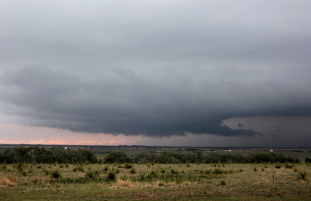
The storm continued to produce up to 1.5" hail along its path from north of Clovis eastward to Pleasant Hill from 7:00 to 7:30 p.m. The pictures above were taken during that approximate time frame. As sunset neared, the storm took on some nice colors as it drifted east toward Texas. However, it also seemed to be weakening, and I needed to get a place to stay, so I broke off and headed back to Clovis, figuring rooms might be scarce due to the number of chasers combined with a holiday weekend. Fortunately, I was able to find a place, and also was finally in a time and place where I could get a real dinner for the first time on this storm-chasing trip.
Day's chase mileage: approx. 250 miles